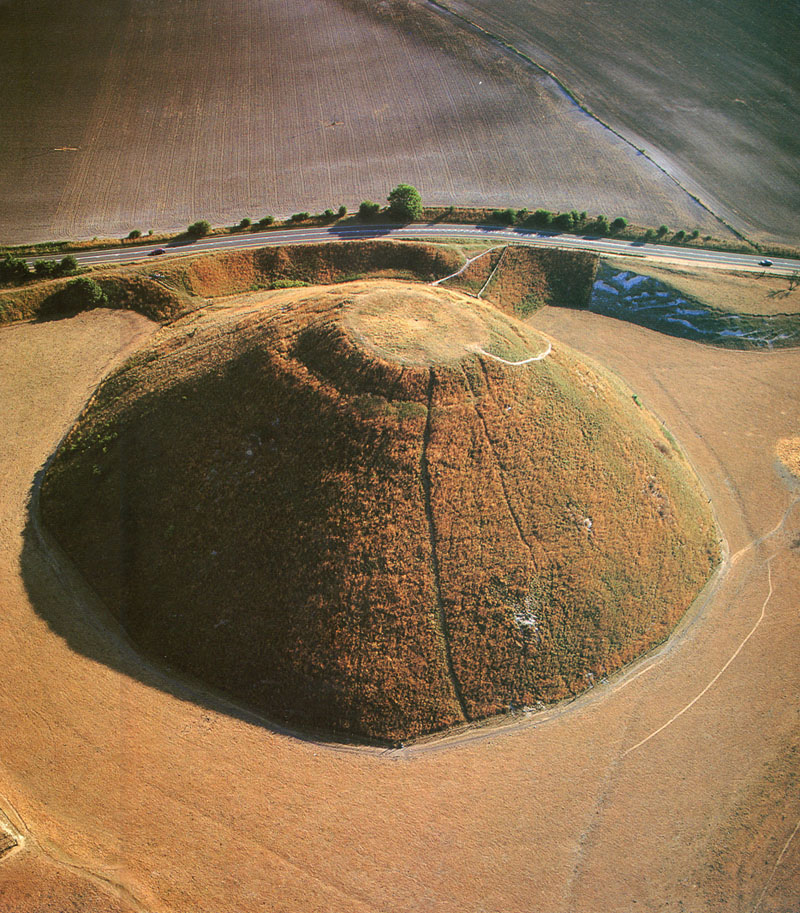
SILBURY HILL
Before returning to finalising the marked positions within Avebury Henge itself, it would be timely to devote some attention to the purpose and function of Silbury Hill, Europe's largest ancient purpose built mound structure. Photo from: Prehistoric Britain From The Air, by Colin & Janet Bord.
In speculating on the purpose of Silbury Hill, one researcher states:
'Many theories have been put forward as to the purpose of Silbury Hill. The eighteenth century archeologist William Stukeley thought the hill served as a viewing platform from which to look at the surrounding monuments. It has also been studied as an English version of a pyramid burial site. Astrological alignments have been searched for without success'.
Of all the theories raised through the ages, Stukeley's makes the most sense. Why would anyone choose to build a huge mound this high if it wasn't to look over the surrounding terrain at specific targets? The ancient surveyor-navigator-astronomer-mathematicians needed a big hill and it had to be at that precise position.
For the very panoramic view, through 360° of vista, that one sees from atop Silbury Hill, go to: http://documents.kennet.gov.uk/avebury/aveburyvirtual/silbury/tour/Silbury.html
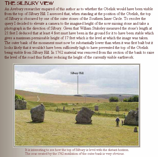
In 2003 I asked a British antiquarian if the huge, tall obelisk at Avebury Henge would have been visible from Silbury Hill and vice-versa. Here's the response, graciously given and gratefully received: http://www.avebury-web.co.uk/silbview.html
All of the essential surveying elements of wide vistas and good views are present from atop Silbury Hill for taking fixes onto a multitude of purpose built mounds in the surrounding landscape. By establishing a very precise distance and angle from the obelisk at Avebury Henge to a target pole or stone atop Silbury Hill, the distances to all other targets could be calculated by trigonometry. Let's look at some outlying mounds and markers from Silbury Hill and consider their coded distances and angles from the Silbury hub or benchmark position.
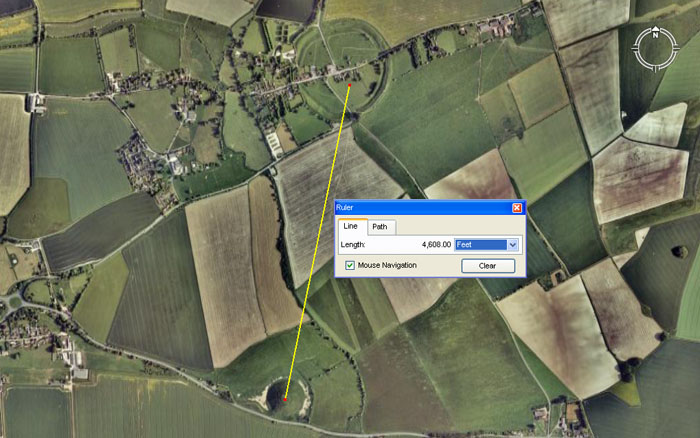
The distance from Silbury Hill's benchmark position to the obelisk at Avebury Henge was coded to be 4608' at an azimuth angle of 11.52°. Both values are a part of the same mathematical progression and 4608' equates to 1152' X 4. Under the 24883.2-mile reading to describe the equatorial circumference of the Earth the sum of 460.8-miles would be 1/54th part.
The 1152, 2304, 4608 progression is clearly encoded into the face square footage value of the Great Pyramid. Herodotus was told by Egyptian priests that each side of the Great Pyramid was 8-pyramid acres. With a base length of 756', a diagonal side length of 576' to the beginning of the flat top altar floor of 44' width, the square footage per side is 400 X 576' = 230400 sq. feet . Therefore, two sides = 460800 sq. feet, three sides = 691200 sq. feet and four sides = 921600 sq. feet or 64 pyr. acres of 28800 sq. feet each.
WHY WAS SILBURY HILL BUILT EXACTLY AT THAT POSITION?
Architects and surveyor-mathematicians of the Neolithic Age had to have a very good reason to undertake a project of this immensity and the placement of the hill was very well-planned for the preservation of dynamic scientific codes. It goes without saying that the most venerated of codes would be assigned to this position in consideration of the mammoth effort expended to build the hill.
A surveyor will always try to use natural landmarks or the highest surrounding hills in view as fix points when precisely establishing building positions within a district. Thereafter, those immovable and eternal, high natural hill trigs continue to function as ongoing points of reference.
The commonly used, primary trig for Avebury Henge's central huge obelisk or the centres of both Durrington Walls Henge and Silbury Hill was Barbury Hill (site of the Iron Age hillfort called Barbury Castle). This towering hill up on the high Ridgeway is situated just 5.3333333 Roman miles (25920-feet), at an angle of 36-degrees, from the central obelisk position at Avebury. Both the very exact angle and distance contain dynamic codes and, by reference to this "outer marker" trig on the crown of Barbury Hill ancient theodolites could be set with absolute precision for degree angle readings onto any target around the horizon.
It becomes evident that the exact positioning of Avebury Henge by its builders was fully linked to the crown trig on Barbury Hill.
Likewise, from the flat top surveying position on purpose-built Silbury Hill the degree angle to Barbury Hill crown is precisely 32.36068-degrees and this value is based directly on the PHI ratio (1.618034 to 1). The sum of 32.36068-degrees = 16.18034 X 2.
Professor Alexander Thom found a recurring measurement to be in evidence on ancient, very weather worn British monuments, which he dubbed the "Megalithic Yard". Thom's average placed the length at or near to 82.9 centimeters, which equates to 32.6378 inches or about 1/4th of an inch greater than a straight PHI based measurement of 20 PHI inches (32.36068-inches). What Thom found and estimated was, without doubt, the PHI based length used universally by the ancient Caucasoid cousin nations.
Mathematically conceiving of the PHI ratio constitutes one of the great scientific accomplishments of antiquity and PHI relationships were built into the dimensions of major edifices, ranging from the Great Pyramid of Egypt to the Parthenon of Athens. One of its greatest practical applications was in the fabrication of very accurate, round volume tubs for dispensing correct quantities of dry or wet goods in the market places of trading cousin nations.
The distance from the top of Silbury Hill to the crown of Barbury Hill was intended to convey 30240-feet (62/9ths Roman miles). Under the Great Pyramid's "6&7" assignment for the equatorial circumference of the world the distance was read as 12 X 12 X 12 X 12 X 1.2 "Greek" miles (24883.2) of 5250-feet each. In this circuit the sum of 30240-feet (note: the Great Pyramid @ 756-feet per side is 3024-feet for one circumnavigation) would equate to 5-minutes of equatorial arc. The distance from Silbury Hill to the crown of Barbury Hill would, therefore, represent 1/4320th of the distance around the equator under that navigational (positional plotting) system. It's very probable that the other navigational systems (for example 30250-feet under the "11" system) would also have been represented by markers on Barbury Hill crown. A distance of 30375-feet (6.25 Roman Miles) would have resolved very nicely within the Barbury Hill enclosure (if it was built contemporary to Silbury Hill) and provided dynamic lunar cycle and navigational codes simultaneously.
In addition, Durrington Walls Henge, 20-miles to the South, obviously used the centre crown position of Barbury Hill as its "true North" outer marker, as the centre to centre relationship between the two sites could not be more perfect in a surveying sense.
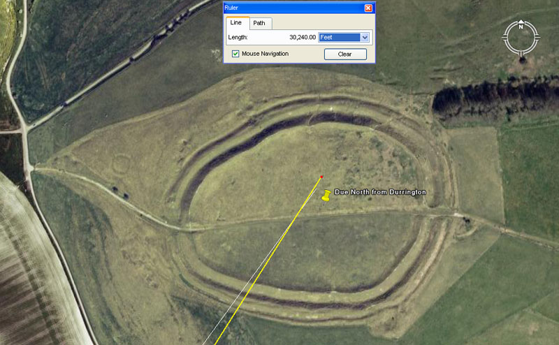
A yellow vector, originating on the top of Silbury Hill is seen to resolve into the central region of Barbury Castle Hillfort, on the high Ridgeway. The angle (32.36068-degrees) is pure PHI-based coding, whereas the distance is navigation-based. A white line is seen to resolve into the centre crown area of Barbury Hill and this originates at the main obelisk position at Avebury Henge. The distance is exactly 25920-feet (coding the duration, in years, of the Precession of the Equinoxes) and the angle is 36-degrees (return angle 216-degrees*). The centre crown of Barbury Hill also represents "true" or "due" North from the centre of Durrington Walls Henge, 20-miles to the South.
*Note: the ancient reed measurement was 126-inches and the Greek foot was 12.6-inches. The ancient British bushel capacity was 2160 cubic inches and this was 1/10th of a Babylonian Homer volume @ 21600 cubic inches. The sun spends 2160-years in each House of the Zodiac during the cycle of Precession and the Moon is 2160-miles in diameter.
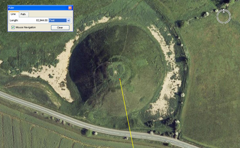
A dynamic surveying relationship exists between the epicentre of Durrington Walls Henge and the top of Silbury Hill. The distance separating these two surveying points was intended to convey 82944-feet (as seen above on the Google Earth panel). With the equatorial size of the Earth anciently set to the formula 12 X 12 X 12 X 12 X 1.2 = 24883.2-miles, the sum of 8294.4-miles would constitute 1/3rd of the distance around the Earth or 120-degrees of equatorial arc. This distance being encoded between structures in Wiltshire, Southern England equates to 48000 of the largest Egyptian Royal Cubits @ 20.736-inches each. This increment of length was positively identified by Sir William Flinders Petrie to be present in the length of the coffer found in the Khafre Pyramid of Egypt. The coffer measured 103.68-inches or 5 cubits of 20.736-inches each.
Depending upon which navigational system one was using for positional plotting at sea, the above distance (82944-feet) would represent the following fractions of the equatorial circumference of the Earth:
Alternatively, the return angle to the epicentre of Durrington Walls Henge is 168.75-degrees and this value is dynamic lunar cycle and navigational coding simultaneously. For example: A lunar year equates to 354.375-days or 21 periods of 16.875 days (405-hours).
The above amount of error in the coded or intended distance between epicentres of the two Neolithic Age structures might equate to about 40-feet in close to 153/4 miles. Any detectible error in the coded degree angle is negligible. The prowess and accuracy of these ancient surveyors is astonishing.
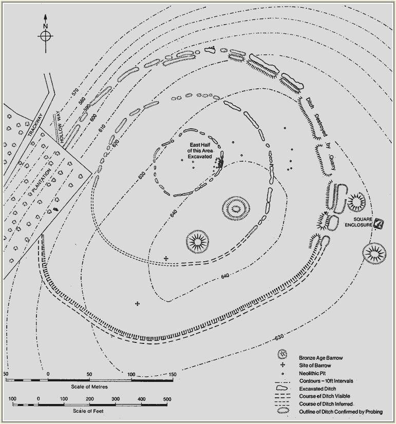
A precisely drawn archaeological plan of the structures atop Windmill Hill. These mounds or very wrecked concentric circle ditch rings can be accurately superimposed into Google Earth.
Of the many mound, arrowhead trench, barrow, enclosure and sighting pit markers adorning Windmill Hill, we'll touch upon these examples for the moment, then move to other markers in the outlying landscape surrounding Silbury Hill and the obelisk position at Avebury Henge.
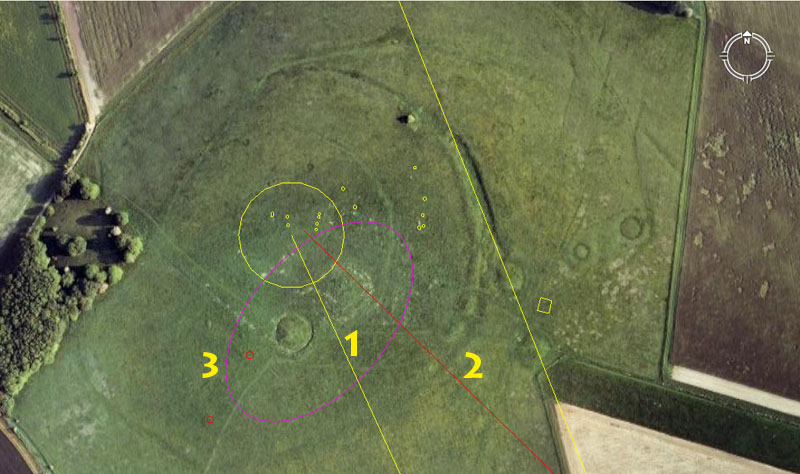
(1) A line extends northwards from the marker position atop Silbury for exactly two miles (10560') and resolves on the centremost concentric circle on Windmill Hill. The azimuth angle back to the Silbury marker is 155.52°.
The distance code is self-explanatory.
The angle of 155.52° (15513/25) is a very strong navigational code and 1555.2-miles would be 1/16th of the 24883.2-mile equatorial circumference.
(2). A red line is seen to resolve into the same inner concentric ring. It runs from the obelisk position at Avebury Henge for 7333.3333' at an azimuth angle of 314.16°.
(3). A purple oval shows the highest part of Windmill Hill, upon which sit two mounds.
(a) The distance from the Silbury Hill marker to the centre of the small mound at the left of the oval is coded to be 10309.909090' (1030910/11). This distance was 6000 Egyptian Royal Cubits of 20.61818182-inches (20136/220ths) each and related to the equatorial circumference of the Earth. There were 3 very close proximity length variations on the Egyptian Royal Cubits and these were 20.61818182-inches, 20.625-inches and 20.736-inches respectively. Each was a mnemonic device for remembering the equatorial size of the Earth under either the "6&7" system of navigation (24741.818181-miles of 5280 feet), the "11" system of navigation (24750-miles of 5280') or the "true" size of the Earth at the equator (24883.2-miles of 5280').
The angle from the mound's centre sighting pit to the marker on Silbury Hill was intended to code 154.6875° (15411/16ths). Under the Great Pyramid's second geodetic system, coding the equatorial circumference at 24750-miles, the sum of 154.6875-miles would be 1/160th part. or 2.25° of arc. The sum of 1546.875-inches would be 75 Egyptian Royal Cubits of 20.625-inches each.
(b) The distance from the Silbury Hill to the mound to the right, within the oval crown of Windmill Hill is 10368' at an azimuth angle of 336°. The distance would equate to 6000 Egyptian Royal Cubits of 20.736-inches each (2092/125ths) (1.728').
The degree angle (336°) is also navigational coding that relates to the equatorial circumference of the Earth and the sum of 33.6' would be 1/3rd of 1-second of equatorial arc (100.8') according to the literal system built into the base dimensions of the Great Pyramid.
The value 336 (half of 672) is expressed yet again in the distance from the small square enclosure shown in the picture above and the map plan. The distance from the obelisk at Avebury Henge was 6720' to this position and the angle from the obelisk was 316.8°, which is again dynamic navigational coding.
Yet another AutoCAD generated line is seen to skim past the trench perimeter of the third outwards concentric circle on its way to a target further to the NNW.
A line extends from Silbury Hill for 32/3rds miles, crossing Windmill Hill en route, to a bush clad site in a farm field. The return angle of 158.4° to Silbury Hill is navigational coding that relates to the diameter of the Earth and equatorial circumference according to the mile of 5280'. English Heritage and local farmers around Avebury, to their credit, have preserved hundreds of sites like this for future decipherment. The archaeological site appears to be made up of at least four mounds and each would be set at a coded distance and angle from either Silbury Hill's benchmark position or the obelisk at Avebury Henge.
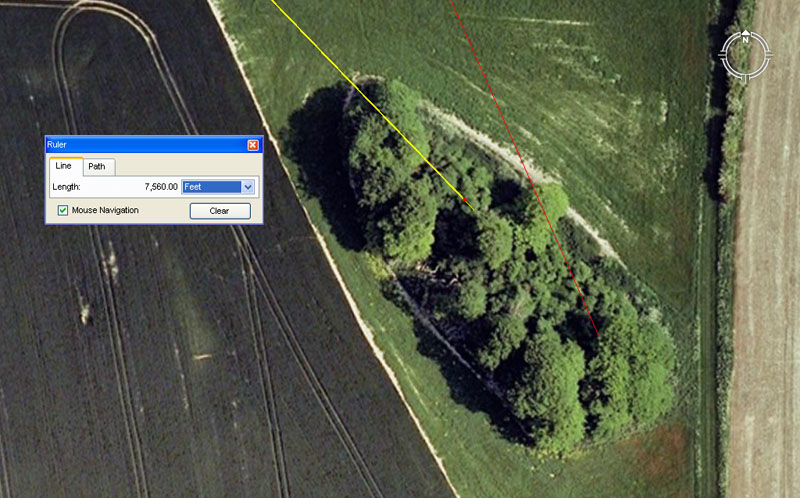
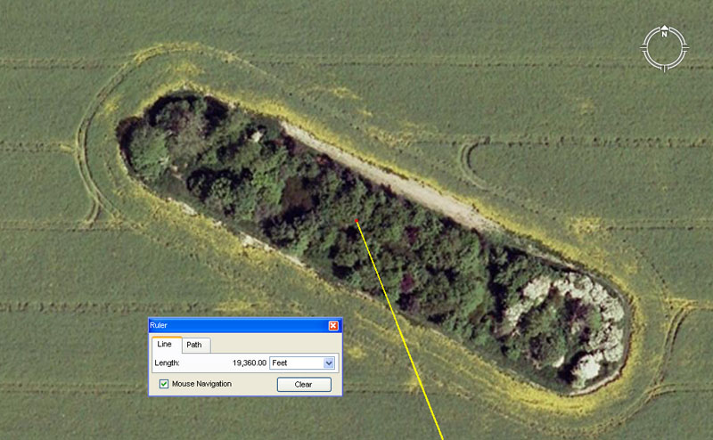
Another example of a bush clad and undisturbed site is "boat-shaped" East Kennet Long barrow. A yellow line extends from the marker position at Silbury Hill for 7560' and resolves to the central zone of the long barrow. The angle of this line, crossing the pointed bow of the barrow, was intended to convey 136.08°. At the same time, a line (red) extends from the obelisk at Avebury Henge for 11000' from Avebury Henge's obelisk at an angle of 156.25° and resolves upon a position near the "stern" of the boat-shaped barrow.
(1). The distance from Silbury Hill is exactly ten times the length of the Great Pyramid. This coding is very much in similitude to the coding of West Kennet Long barrow, the doorway stone row of which sits exactly ten times the length of the Khafre Pyramid distant from the obelisk position at Avebury Henge (7087.5'). Significantly, the angle from the doorway row to the henge obelisk is exactly 354.375° (note: half of 708.75' or the length of the Khafre Pyramid is 354.375' and this value is the number of days in a lunar year).
Similarly, the distance from the marker on Silbury Hill to the doorway of West Kennet Long barrow was intended to code 3024' (756' X 4) or one circumnavigation of the Great Pyramid ... 1/2 of 1-minute of arc for the equatorial circumference of the Earth.
The code contained in the azimuth angle from Silbury Hill to East Kennet Long barrow relates to the lunar nutation cycle, where the Moon moves from lunar major standstill to lunar minor standstill, then back to lunar major standstill. This duration was anciently factored to be 6804-days (note: 6804 X 2 = 13608). The sum of 136.08-days would be 1/50th of the cycle.
(2) Alternatively, the 11000' distance from the obelisk at Avebury Henge to East Kennet Long barrow equates to 2 1/12th miles. The angle of 156.25° also provides a mathematical progression value related to the "11" series mile.
In the opinion of this researcher, significant markers or a door entryway, etc., should exist on the otherwise unexcavated East Kennet Long barrow in accordance with these distance and angle codes extending from both Silbury Hill and the obelisk position at Avebury Henge.
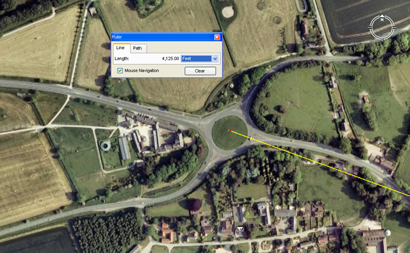
A crossroads intersection has been built around this ancient mound, the centre of which sits 4125' from the marker position atop Silbury Hill. The angle to Silbury is 110°. In both distance and angle the readings are in homage to the "11" series mile of 5280'.
1. Under the Great Pyramid's second geodetic system where the equatorial circumference of the Earth was set at 24750-miles, the sum of 4125-miles would be 1/6th part or 60° of arc.
2. A mathematical progression based upon 4125, will deliver up very significant values associated with the "11" series mile. For example 4125' would be 1/4th of an ancient League (16500' or 3.125-miles).
3. The azimuth angle (110°) from the mound to the Silbury Hill marker also relates to the "11" series of overland lengths and 110' would be 1/48th of a mile or 1/150th of a league.
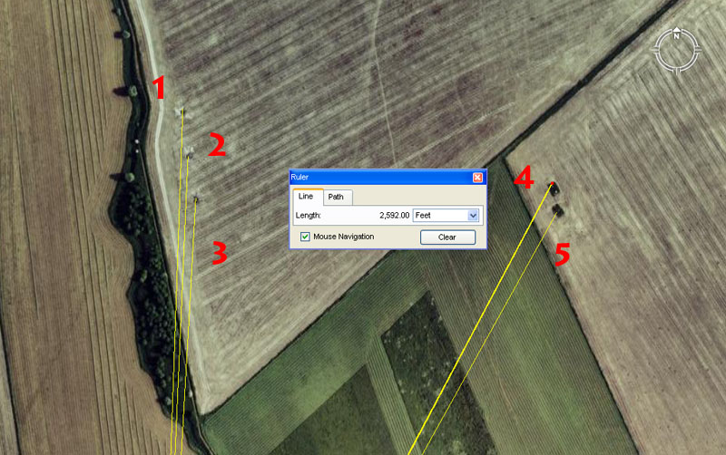
A grouping of marked positions sit half a mile or so the NNW of Silbury Hill and each site contains codes of position for students taking fixes to or from the marker on the crown of Silbury Hill. The extractible codes are:
1. Site 1 sits 2520' from the former Silbury marker @ a return angle of 182°.
The 2520' distance codes a calendar and navigational value and 2520' would be 25 seconds of arc (of 100.8' each) according to the Great Pyramid's literal geodetic system (note: the length of the Great Pyramid @ 756' = 252 X 3). The 252, 504 value or progression was also highly important to calculating the lunar duration component of the Sabbatical Calendar or calculations related to the duration of the lunar nutation cycle of 6804-days. The sum of 2520' would be 2400 Greek feet or 1200 Assyrian Cubits.
The return angle @ 182° also offers coding related to the Sabbatical Calendar. Under that system the raw-count or agrarian year was made up of 13-months of 28-days each (364-days or 182 X 2). This count was allowed to persist undisturbed for 7 such years (2548-days) at which time a 9-day festival began and the intercalary correction days were added in. At the end of this Sabbatical Year, the count commenced anew with everything fully corrected.
Alternatively, the 182° could be read as 182.25 (1821/4th) and relate to the lunar count. Under the Sabbatical Calendar lunar count of 7.2 lunar years (2551.5-days) being monitored alongside 7-solar years (2556.75-days), the sum of 182.25-days represented 1/14th of the duration.
2. Site 2 sits 2376' from the former Silbury marker @ 182.625° return.
The distance code is navigational and relates to a reading of the equatorial circumference of the Earth under the 24750-mile assignment. Under that reading the distance in feet would be 130680000, of which 2376' would be 1/55000th part.
The degree angle is related to the solar year of 365.25-days in which 182.625-days (1825/8ths) represents half the year or the true number of days and hours between equinoxes.
3. Site 3 sits 2250' from the former marker atop Silbury Hill @ 3.24° angle from Silbury.
The distance is simply in mnemonic reference to the 360-degree circle wherein 22.5° represents 1/8th part.
The degree angle code is in homage to a mathematical progression related to the equatorial circumference, as well as the duration of the Precession of the Equinoxes. In the 25920-year cycle of Precession, 324-years would be 1/80th part.
4. Site 4 is again focusing on the duration of the Precession of the Equinoxes and a line from the Silbury marker runs for 2592' @ a degree angle of 27.7777° (277/9ths). The value of .2777777777777 (5/18ths) is the reciprocal of 3.6 (18/5ths) and these swapping values were useful in calculations to do with seconds, minutes, degrees and ranging up to a full circumference reading on a circle.
5. The coded distance is 2531.25 and the degree angle is 29.16 (294/25ths).
The distance is a lunar reading and 25.3125-days (255/16ths) would be 1/4th of a lunar year.
The angle code is navigational and 29.16-inches would be 1/2 of a Roman Pace measurement.of 58.32-inches. A very small adjustment to the degree angle to render it 29.1666666° (291/6th) would have produced a value that was integral to a very important lunar mathematical progression.
There are many, many more of these outlying mounds circumnavigating Silbury Hill and, in all, of the eighty-six studied so far by this researcher, all comply to very recognisable distance and angle codes out from Silbury Hill. Eighteenth century archaeologist, William Stukeley's conclusion that "the hill served as a viewing platform from which to look at the surrounding monuments" is quite correct and remains the only plausible reason why the hill-sized mound structure was built in the first place.
OTHER CURIOUS ANOMALIES IN THE WILTSHIRE LANDSCAPE
In the course of working across the 2005 Google Earth image of the landscape surrounding Avebury Henge and Silbury Hill, other intriguing items were encountered. The remains of at least five crop circles from the 2005 season are still in evidence in the farm fields. Inasmuch as the epicentre positions of some can be fixed with considerable accuracy, it might be a worthwhile exercise to see if any of the circles comply to similar codes of position as are found on the ancient mounds.
This researcher has no opinion regarding who put the circles there in the cereal crop fields, whether that be Doug & Dave or more outer-worldly visitors to the district. The crop circles are simply there, tangibly in place and very measurable, so let's subject them to the same clinical scrutiny as has been applied to the mounds.
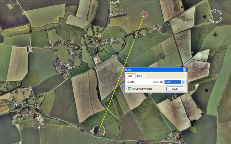
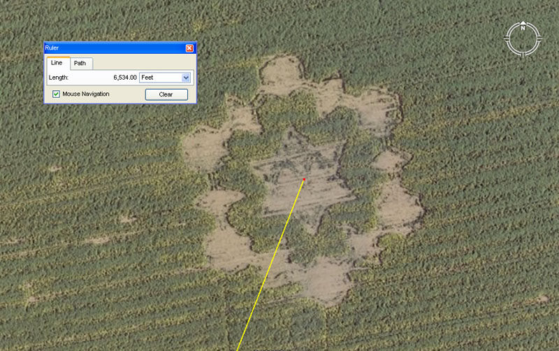
A line runs for 6534' to the centre of a crop circle lying to the northeast of Avebury Henge. The angle to this position from Silbury is 21.333333° (211/3rd). The epicentre of the crop circle sits at: 51.432344° Latitude, -1.846999° Longitude.
So, could this be construed to mean anything? ... Well, umm, err ... yes it could.
The distance of 6534' is a very important increment that recurs in mathematical progressions related to the 24750-mile equatorial circumference of the Earth. As has been stated, if the Great Pyramid @ 756' per side was elongated a mere 3-inches to 756.25' per side, then two circumnavigations of the structure 6050') would represent 1-minute of arc in a world where a degree of arc was 68.75-miles and the full circumference was 24750-miles (130680000'). The sum of 6534' would be 1/20000th of the total distance around a world factored to that size. Note 6534 X 2 = 13068.
Similarly, the degree angle works well in a mathematical progression related to navigation. This same angle could be read as a dynamic lunar progression code of 21.2625° (2121/80ths). The sum of 21.2625-days would be 1/320th of the 6804-day lunar nutation cycle or 1/120th of the 7.2 lunar years monitored within the Sabbatical Calendar. Over the 6534' distance, the difference in the two degree angle vectors would be 8' of spread..
The crop circle seems to be 420' across and two points of the hexagram star seem to lay on a line that orientates 348°, 168° North-South. Note: 42 X 4 = 168. This puts the other rays on 48, 108, 228, & 288° respectively (of these angles 48, 108, 168 & 288 are highly important factorable values, much used in ancient mathematical progressions and calculations).
In terms of converting this "6&7" diameter circle into an "11" circumference using PI @ 22/7, this produces a circumference of 1320'. Whereas there would be 121/2 occurances of 420' in a Greek mile of 5250', the sum of 1320' would be 1/4th of a British mile of 5280'. This kind of conversion is exactly what was being taught to students of navigation on the western row of obelisk stones arrayed down West Kennet Avenue.
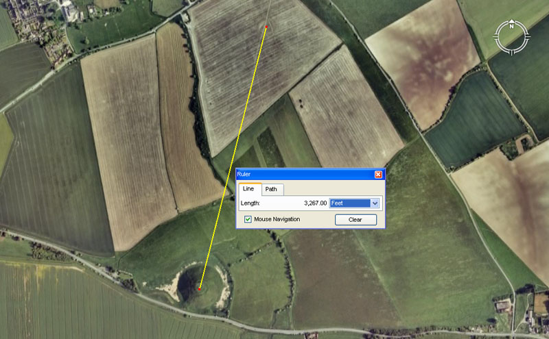
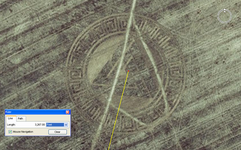
A line runs for 3267' to the centre of a crop circle lying to the NNE of Silbury Hill. It is still very vividly in evidence close-up in this field after harvest. The angle to this position from Silbury is 14.175° (147/40ths). The centre of the circle sits at 51.424343° Latitude, -1.853919° Longitude.
So, could this be construed to mean anything? ... Well, umm, err ... yes it could.
Remember how that last crop circle was 6534' away from the former marker position atop Silbury Hill? Well this one sits exactly half that distance away at 3267'. Remember how the earlier degree angle was in the very near range of 21.2625, well this one is 14.175° (147/40ths), which is 2/3rds of 21.625°.
The 1417.5 value is a very important lunar code and the Khafre Pyramid @ 708.75' per side = 1417.5 for two side values. The lunar year is 354.375-days or 1/4th of 1417.5.
This second crop circle has a diameter very close to 260'. If read as 259.2' the value would relate to the 25920-year cycle of the Precession of the Equinoxes.
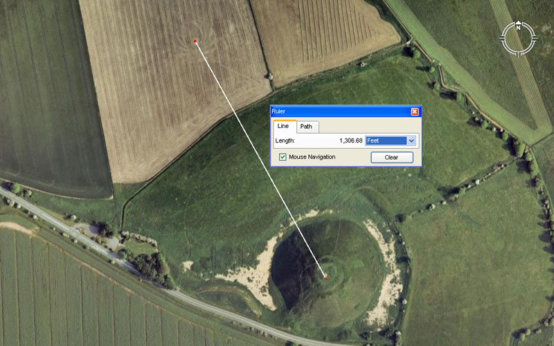
A third crop circle mark is still clearly discernable in this harvested field NNW of Silbury Hill. The approximate centre of the circle sits (for the purposes of this exercise) at 1306.8' from Silbury's marker, at a return angle to the hill very close to 151.2°. The smudged centre position of this crop circle is very close to 51.418797° Latitude, -1.850217° Longitude.
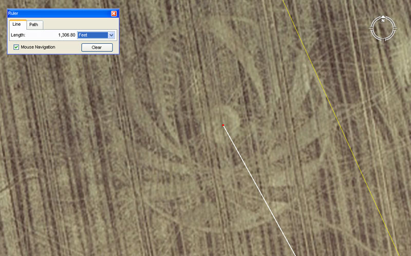
Although the harvest of the cereal crop has taken place, the impression of the crop circle is still very much in evidence. To the right hand side of the picture a yellow line is seen to brush the edge of the circle en-route to the centre concentric circle atop Windmill Hill. That position lies 10560' (exactly two miles) from Silbury Hill's marker position.
So, could this be construed to mean anything? ... Well, umm, err ... yes it could.
Again we have a repeat of the 6534 code and this circle sits 1/5th of the distance out from Silbury Hill compared to the first one mentioned. Alternatively the second crop circle mentioned sits exactly 21/2 times further out than this one, so all are ratio expressions of each other. The panel above reads 1306.8, which is 653.4 X 2. The circumference of this third circle would be very close to 653.4', based upon a diameter that is just under 208'.
The angle back to the Silbury marker sits very close to 151.2°. It will be remembered that the angles exhibited on the first and second crop circle positions complied to lunar coding based upon the value 14175 and it was mentioned how 1417.5' represented half the perimeter value of the Khafre Pyramid. By consequence the sum of 1512' would be half the perimeter value of the Great Pyramid.
So, if these 2005 crop-circle making capers were the clandestine, nocturnal work of semi-inebriated Doug and Dave, fresh from the pub with their rope and plank, then this researcher is very impressed.
To be continued.
©
Martin Doutré
Series initiated June 1st 2009.