THE CAHOKIA MOUNDS COMPLEX
ANCIENT OPEN-AIR UNIVERSITY OF NORTH AMERICA - FOR TEACHING NAVIGATION & CYCLIC ASTRONOMY.
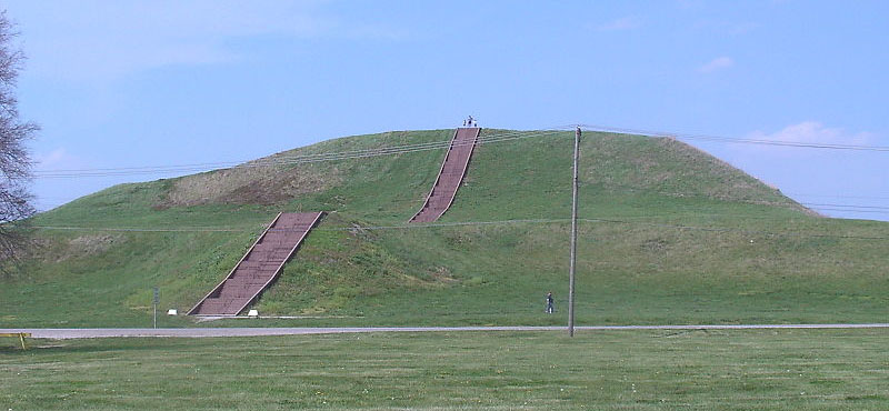
Huge Monk's Mound at Collinsville, Illinois, is the biggest purpose-built ancient structure in North America, with base dimensions considerably larger than those of the Great Pyramid of Egypt. Standing away from Monk's Mound at precise, pre-planned distances and angles, were about 120 smaller mounds. Each of these was a "classroom" in its own right and contained specialised codes-of-position, with these satellite mounds acting as repositories of mathematical information that ancient students of navigation would need to memorise.
In the 1880's North American archaeology took a bad wrong-turn and has never been able to get back on track. Generations of people had looked with wonderment and awe at the huge mound groupings or geometric earth embankment complexes scattered across the length and breadth of North America and decided that these could not be the works of Indians. This conclusion was supported by the vast amount of skeletal evidence found in the mounds, sometimes in deep chambers far from the surface, of very large individuals achieving heights of seven to eight feet in stature. In a few instances, the skeletons had six fingers, six toes and double rows of teeth. Where hair was still present, it was often red or blond in colour.
John Wesley Powell, who had lived for many years amongst the Indians and had tremendous empathy for them and their plight, became the the first director of the U.S. Bureau of Ethnology at the Smithsonian Institute. Whereas the general consensus of opinion amongst Americans, based upon compelling evidence, was that an early-epoch civilisation with no links to the Indians had built the mounds, Powell decided otherwise. His works led to the hard-nosed concept of "Isolationism" (as opposed to "Diffusionism") prevailing within the Smithsonian Institute, which, thereafter, religiously adhered to the policy that the Asiatic-Indians were the only people who had ever been in the Americas prior to Columbus and, as a consequence, they and they alone were responsible for the great earthworks of North America.
The concepts of Powell developed into the Ipse Dixit dogma that dominates North American archaeology today. This uncompromising-immovable dogma (based upon Powell being the final, never-to-be-questioned, authority) is forced to label tens of thousands of anomalous, contrary artefacts as "fakes" and will never consider the amazing evidence inherent within them.
At about the same time Powell was establishing his form of "isolationist religion" in the Americas, another individual called Franz Boas was radically revising American anthropology. For reasons best known to himself, Boas seemed to hate the idea of "race". Despite the obvious fact that a diminutive African pygmy is very different in physiology to a tall Zulu or an Inuit Eskimo is physically very different to a Norwegian Caucasoid, Boas decided we're all pretty much the same and the differences between us are negligible. His "cultural-relativism" theories went on to spawn modern-day "social-anthropology", with its myriad of intrusive appendages, which has largely overshadowed the science of "physical-anthropology" and effectively nullified its ability to provide clinical analysis when skeletal remains are found in archaeological digs. The main focus of Franz Boas seems to have been to convince us all that everyone is as intelligent and able as everyone else. In essence, Boas, like Powell, was reacting against contemporary concepts of his time related to “beings of an inferior order".
Regardless of how well-intentioned Powell's or Boas's motives might have been in according pride to or raising the profile of those relegated to second-class status within North American society, they did nothing useful towards answering the outstanding questions of who actually built the North American mounds and why. Powell and Boas, in their separate but related disciplines, only succeeded in diverting the argument away from the real issue.
As isolationism, along with evolving concepts of social-anthropology (laced with cultural Marxism and its great gift to the world, "political correctness"), took root in America, what followed was stifled or controlled archaeology, eternally locked into proving that "Native-Americans" were the only people who had ever occupied North America prior to about 1500 AD. This meant that anomalies had to be discounted or ignored in order to sidestep dealing with them.
In just one of a multitude of unwelcomed categories, there have been literally thousands of old world scripts found incised into boulders and stone surfaces across North America (some estimates range to 30,000 such artefacts). The scripts are in ancient forms of readable Minoan, Phoenician, Hebrew, Egyptian, Runic or Ogham, etc., but apparently they're all the work of dastardly fellows bent upon deceiving the gullible public, or simply "plough mark" scratches. Vast quantities of evidence and artefacts were given, in good faith, to the Smithsonian Institute in the 1800's and thereafter, never to be seen or heard of again.
The legacy of Powell & Boas, handed down to the rest of us, ensured that our archaeological evidence could never undergo proper scientific testing, lest it upset the apple cart.
These-days, cold, hard, clinical facts are not the preferred route to the formulation of theory, but the social implications of the evidence have to be weighed in the balance before it can enter the public arena. Everything is stringently controlled and "history" must comply to a pre-conceived and pre-written script. Tight "terms of reference" disallow "history" to drift outside of set parameters and everything in upper-academia has to be peer-reviewed to make sure potential fringe-dwellers and mavericks don't threaten the acceptable paradigm.
We have fully documented, reliable accounts of Smithsonian Institute personnel traveling to 1800's communities in middle-America to take possession of large skeletons exhumed from the mounds. In certain instances the handover of remains and artefacts was done with a degree of formal ceremony, with the town mayor, local minister or assorted dignitaries turning out, and the spectacle of speeches and handshakes reported in the local newspaper. Mound researchers like Patricia Mason of Newark, Ohio, in following up on these many reports, have applied to the Smithsonian Institute for information related to present-day whereabouts of those skeletons gifted to the museum's collection, only to be told that the Smithsonian never received any such item.
In many other recorded instances the large bone and heavy skull, remains, found in the mounds, were so old that they disintegrated quite quickly after being exposed to air and, within a few days, had crumbled to powder. This clearly shows that some of the remains were of very great-age.
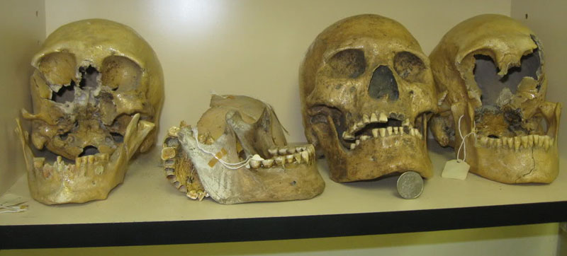
These giant skulls are stashed-away, somewhat "out-of-sight, out-of-mind", at the Humbolt Museum in Nevada. They are the remains of the last of the "Red Headed Giants"of the area, who were trapped inside Lovelock Cave by the Paiute Indians, then suffocated to death by smoke from fires lit at the mouth of the cave. Some skulls of the large boned & tall stature people, recovered from the cave, had red hair. These very big people fit the more general recorded descriptions given of the physical-type found interred within the North American mounds during excavations of the 19th century, when many full skeletons were gifted to the Smithsonian Institute.
And the deception continues. In 1999 I was contacted by a friend who ran a bookstore, selling books on alternative science and archaeology, etc. A young lady had come into his store and they got to talking about archaeological anomalies. During the course of the conversation she gave an account of an experience she had while working for the U.S. Parks Service. The location was Canyon de Chelly National Monument, Chinle, Navajo Reservation, Arizona. A big washout had occurred in the canyon after torrential rains, and a number of skeletons were exposed at a few sites. All of the Parks Service personnel were pressed into service to gather up and box up the newly exposed bones. However, in a somewhat sinister twist, all of the work was overseen by personnel from both the Smithsonian Institute and the FBI. The Parks Service workers were forbidden to bring cameras to the site and were subjected to full body searches by the FBI when arriving in the morning or leaving at night. All of the skeletal remains and artefacts were carefully boxed up and taken away by the Smithsonian Institute. The Park's Service workers were forced to sign secrecy agreements of non-disclosure of information related to their activities in the canyon.
Through the friend who had recounted the details, I tried to track the young lady down, but was unsuccessful. Later, I shared the second-hand account with Viewzone Magazine and this, surprisingly, caused quite a stir across the United States. I later received a fairly irate email from the young lady, who had been thrust under the public spotlight against her will. After tearing a few strips off me, she offered some corrections to what was now in the public arena, saying:
One grave- male, 7ft approx, 6 fingers/6 toes is right- but the teeth were like human, except they had no canines (eye) teeth, and extra large molars and incisors. The skull was large- heavy jaw and long/large cranium. Large eye sockets. Finger bones extra long, but small hands. Buried with beautiful pottery and baskets of fine weave- never seen anything similar. A necklace of fiber and feathers. He looked rather fresh for 6,000 year old, as the Smith [Smithsonian] people claimed. Clean bones- but not brittle ...
The other things about the FBI, etc.,
are all correct, except about the U.S. hassling me when I left. It was when
I came back to the U.S., after a month in NZ, that I was hassled by them,
but let in after 4 hours of questions about my travel plans. I was also refused
entry in to Canada- no explanation.
The Smithsonian is said to have a huge warehouse underground in New York City,
with thousands of skeletons, objects and information.
On the one hand, I deeply regret that I put the young lady in jeopardy with the American authorities. Getting offside with the FBI is not something to trifle with. On the other hand, it's appalling that the American people are so blatantly denied access to very important archaeological evidence, which would quickly clarify mysteries related to long-term regional history. Whereas North American archaeology has been stagnated or has gone backwards for 130-years, all of the essential evidence is in the hands of the authorities to rectify that abysmal situation, but is kept permanently under wraps and beyond the reach of the socially-engineered American public.
For insights into just how much archaeological information has been suppressed or destroyed by the Smithsonian, see: http://www.xpeditionsmagazine.com/magazine/articles/giants/holocaust.html
To see how insideous, draconian legislation attempts to stop
Americans from ever learning the truth about their long-term history see:
http://www.youtube.com/watch?v=sgyoV9TD3kQ
(The Kennewick Man Bill).
So, isn't it amazing, when the police find a substantially complete skeleton under the local bridge, the coroner can quickly identify the "race" or mixture of "races" of the victim ...along with sex, age or how death occurred, etc, etc. Likewise, after WWII, physical-anthropologist, Dr. Mildred Trotter and her colleagues identified and pieced together the (often) shattered skeletal remains of US servicemen, who had died in the Pacific theatre of conflict. Trotter was dealing with many racial types, including Caucasoid, Negroid, American Indian, Chinese, etc., along with some Japanese servicemen or others who were occasionally found in the jumbled mix of MIA bones. For some illuminating insights into Trotter's tell-tale reading of the bones and more especially the craniums, see: http://beckerexhibits.wustl.edu/mowihsp/words/TrotterReport.htm

Mildred Trotter identifying remains of American MIA's at The Central Identification Laboratory of the American Graves Registration Service, Schofield Barracks on Oahu in 1948-49.
When it suits the authorities, physical-anthropological analysis is deemed to be very useful tool and a fully-fledged science. However, when it doesn't suit them, the science is relegated to the "racist" fringe and mere mention of the sub-category of "Craniology" as a legitimate science is sufficient to get one labeled a Nazi. And so we face the rather ridiculous dilemma wherein the science is fully available to criminologists and coroners, but only partially available to archaeologists ... if the remains are clearly "indigenous" and the find in no way negatively impacts upon acceptable mainstream views.
North American Indian historian, Vine Deloria jr. wrote: 'There's
no effort to ask the tribes what they remember of things that happened.
He goes on to say, 'numerous tribes do say that
strange people doing this or that came through our land, visited us, and so
on. Or they remember that we came across the Atlantic as refugees from some
struggle, then came down the St. Lawrence River and so forth. There's a great
reluctance among archaeologists and anthropologists to break centuries-old
tradition and to take a look at something new ... As for the history of this
hemisphere from say, five thousand B.C. forward to our time, the mainstream
scholars just don't want to deal with that at all. Let me give you an example.
Years ago I spoke at an academic archaeological conference, and at the end
of my speech I asked, 'Why don't you guys just drop the blinders and get into
this diffusionist stuff?' My host, David Hurst Thomas, just about lost it
and said, 'Do you know how long and hard we've fought to get members of this
profession to admit that Indians could have done some of these things? And
now you're saying it was Europeans!'''.
THE CAHOKIA MOUNDS.
Words are inadequate to describe the sheer immensity of work undertaken to build this complex of (an estimated) 120 mounds in Collinsville, Illinois (7-miles East of Old St. Louis) or the other 27 or so known to have existed across the Mississippi River in Missouri (Old St. Louis). Monk's Mound alone could have, by some carefully arrived at estimates, taken up to a century or more to build. One writer describes the mammoth task like this:
Hard packed clay weighs around 100 pounds per cubic foot to 120 pounds per cubic foot. Taking the conservative amount of 100 pounds per cubic foot, the mound's total weight equals approximately 2.16 billion pounds. If each basket of earth used to build the mound weighed fifty pounds, then it required 43.1 million baskets of earth to build.
A lot of time would be required to deposit a volume of 21,551,623 cubic feet that composes Monks mound. If a population of citizens lined up with baskets and deposited one basket every minute, it would take 82 years (Julian) to build Monks Mound. If one basket was deposited every second, it would take 1.3658 years. If Cahokia "accepted" population estimates are correct at 20,000 people at the peak of occupation, then each person would have to carry 2155 baskets (53.9 tons) to complete the mound. The combined volume of the other mounds on the site roughly equal the volume of earth used in monks mound. That means it is safe to double these estimates to consider the entire amount of work done at the Cahokia Mounds. Now consider that thousands of mounds were built all over the country. The sheer workforce used to build these mounds is a feat that cannot be matched by any ancient culture throughout the world.
Then, just when we think we're off the hook and can relax again, the researcher throws in this curve ball:
The average distance of the nearest ten
borrow pits to Monks Mound is 4624 feet (1541 yards). The total area of borrow
pits at the Cahokia site is 2.01 million square feet. If the earthen construction
materials used in monks mound came from these borrow pits, they would each
have to be about eleven feet deep throughout the total area. However, the
actual depth of the borrow pits today is around 2-5 feet deep. This could
be attributed to erosion and flooding deposits in the low areas. When considering
the total volume of the mounds at the Cahokia Site, if the earth for the mounds
came from the local borrow pits, they would have to be around twenty feet
deep. Non local colored soils found on Monks Mound indicates that it is likely
that the earth used to build the mounds did not all come from local sources,
but was instead brought in from larger distances.
http://www.freewebs.com/historyofmonksmound/index.htm.
So, we're beginning to gain some appreciation of just how huge this building commitment truly was. Basic logic tells us that no-one would have dedicated themselves to this task, spanning generations, without a very, very good reason that they fully believed in and supported unreservedly. Moreover, the Cahokia complex is not the only example of a vast group of inter-relating mounds in North America, so the impetus to undertake such a hair-brained scheme can't be attributed to some lone, despotic, control-freak chief, wanting his own set of tailor-made, lofty hills to stand on. The fact of the matter is that the Cahokia complex is just one more batch of earthen pyramids and mounds, found clustered together in individual groupings, built over several continents between 5000-1500 BC.
Our archaeologists look at the mounds and see little more than big piles of dirt. Because they can't find any rational explanation for going to that much effort, they proffer a few implausible possibilities and leave it at that (ceremonial purposes, status, etc.). But our experts aren't looking hard enough. The humps themselves are not placed willy-nilly and erratically across the landscape. Each one was very carefully positioned, based upon a premeditated plan, pre-survey and careful marking of the intended layout over a vast tract of terrain, before the baskets of dirt began to arrive to erect each individual mound.
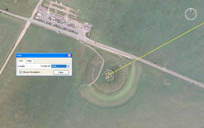
The Cahokia mounds themselves are fully-fledged surveying markers and, although no visually apparent symmetry is detectible in the overall pattern , each mound sits out from a central fulcrum or hub position at a carefully coded distance and degree angle around from North. If one then understands the ancient measurement standard used in the layout, as well as the ancient 360-degree angle system attributed to the Sumerians (but found to be present in other mound-marker complexes that predate that civilisation) then one has everything required to read the carefully in-built tutorials of each mound position.
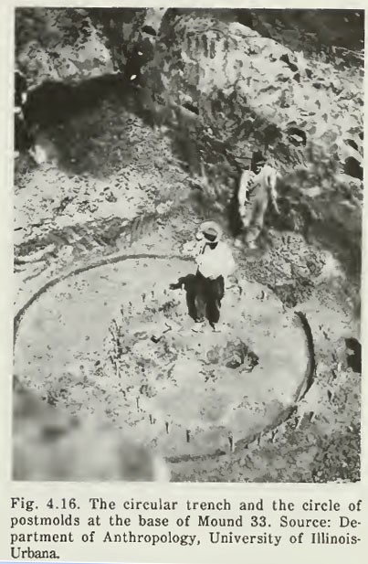
In the Spring of 1922, Moorhead began an excavation down through the centre beneath the summit of Mound 33. At a depth of 23 feet he located the base of the mound and also found '(1) A circular trench, nearly a true circle, 3 inches (7.6 centimeters) wide and 20 feet (6.1 meters) in diameter (Figure 4.16). There were no ashes or charcoal in the trench. (2) Crossing the center of this circular trench and extending slightly south of it was a circle of postmolds 2 to 3 inches (5.1 to 7.6 centimeters) in diameter (Figure 4.16). Many of these were preserved as charred stubs and charcoal'. See: The Cahokia Atlas, A Historical Atlas of Cahokia Archaeology, by Melvin Fowler, pg. 87.
What Moorhead had obviously encountered was the original survey marker (with a finalised, refinement circle overlaying it), put in place by ancient surveyors to determine the precise epicentre position for mound 33, prior to its construction.
And it all makes such perfect sense. Why have our archaeologists been standing around endlessly scratching their heads and wondering what the mounds were built for, but never advancing beyond the most rudimentary and implausible scenarios? Surely, a concept that would immediately spring to mind is that the mounds could have been made as some kind of layout based upon meaningful distances and angles between structures. One giant structure (Monk's Mound) eclipses the rest in size, so that must be the centre-piece for the whole site ... gee ... I wonder if that could be acting as some kind of fulcrum position? ... hmm ... I wonder if there is anything repetitious in the distances and angles out to the satellite mounds or if any ratios can be found by comparing the vectors? ... hmm ... If I do some comparative analysis with similar mound sites overseas, I wonder if I'd find any duplication of the same distances and angles?
Then, to further exacerbate the situation, the archaeologists make their measurements in "metres", which standard is a modern-day invention, a full step removed from old, traditional metrology. The metric system does nothing more than totally obscure the old numbers so that they are utterly unrecognisable. To see what's happening on these sites one has to revert (& this will be surprising to some) to "feet & inches", which have a long enduring pedigree back to the earliest civilisations of remote antiquity.
IT'S ALL ABOUT NUMBERS.
It was obviously realised in remote antiquity that if one is to enjoy the abundance and benefits of "CIVILISATION", then there is a body of essential, prerequisite scientific knowledge that must first be gained. Once a civilisation has that knowledge, then they must religiously preserve it and hand it on intact to each ensuing generation. Failure to do so means that one has just cursed one's children and to whatever degree the knowledge is lost, so too is lost one's grasp on civilisation.
One truth that will come as a surprise to some is that the "so-called" British Standard "inch" and "foot" are very ancient and all of the cubits or feet of the great civilisations of recorded history were based upon the selfsame inch. Moreover, all of the measurement standards of one civilisation were either the same, or precise ratio expressions to the standards of the confederation of cousin civilisations. Everyone used the same integrated parcel of factorable numbers to describe their sciences and the way they eternally recorded those sciences was by incorporating those numbers into all of their public buildings or in the layout of marker-mound and standing-stone complexes. As we proceed we'll extract the in-built codes of position for 104 mounds at Cahokia, plus others further to the West on the Mississippi Bluffs of Old St. Louis.
Patricia Mason, a leading authority on the geometric earth
mound complexes and burial mounds of Ohio and Pennsylvania, etc., USA, made
this researcher aware of the 19th century work of J. Ralston Skinner,
who analysed survey results of Ohio's geometric earth-embankments. Skinner's
conclusion was that the mound builders of the Ohio Valley had positively used
the increment known as the British standard inch in the design
and construction of the ancient geometric complexes. See: Skinner,
J. Ralston. "Identification of the British Inch as the Unit of Measure
of the Mound Builders of the Ohio Valley." Journal of the Cincinnati
Society of Natural History Vol. 9 (July 1886), pp. 51-63.
This journal can be accessed online by going to: Cincinnati Historical
Society Digital Journals.
The finalised, big numbers that had to be remembered by ancient civilised society might look reasonably unfriendly. This is because nature has a bad habit of running cycles to its own schedule, without consulting accountants. A solar year is 365.2422-days and a lunar year is 354.3643519-days. The lunar nutation cycle, where the moon goes to a position called major standstill, returns to minor standstill, then returns to major standstill again, takes 6798.36-days or 18.61329277 solar years. The Earth is 24902.44523-miles in equatorial circumference. The polar circumference is 24816.55084-miles. The cycle of the Precession of the Equinoxes takes 25776-years to complete.
So, with these cumbersome, non-factorable numbers to contend with, how did ancient scientists turn this chaotic set of difficult values into an ordered, integrated and functional mathematical system?
-
The solar year can be called 3651/4-days, which is a nice rounded number equating to 8766 hours.
-
The lunar year can be called 3543/ 8-days, which is 8505 hours.
-
If a calendar is produced that runs for 7 solar years, then that equates to 2556 3/4-days.
-
If the lunar period within that calendar runs for 71/5 lunar years (one tenth of 72-years), then that equates to 2551 1/2-days.
-
If a measurement rule is produced, based upon 51/4 feet, then 487 X 51/4 = 25563/4 feet/ days.
-
The same measurement rule can be used for the moon and 486 X 51/4 = 25511/2 feet/ days.
-
If an auspicious mistletoe culling ceremony is performed on the 6th day after the calendar commences at the Summer Solstice, then the solar and lunar cycles can end on the same day 7 solar years later.
-
If the world is described as 12 X 12 X 12 X 12 X 11/5-miles (note: 11/5 is a tenth of 12), then that's 248831/5-miles...only 18.8 miles short of the true equatorial circumference.
-
If one wishes to navigate using a "6&7" series of numbers, those miles can be 5250' each.
-
If one wishes to navigate using an "11" series of numbers, those miles can be 5280' each (for a world with a circumference of 24750-miles).
A wonderful little window of opportunity arises when a straight-line diameter, using an "11" number is converted to a "6" based circle using PI @ 314 2/11 ÷ 100 (1728/550). Therefore 550 X this rendition of PI = 1728, which is fluidly divisible by 360°.
A wonderful little window of opportunity arises when a straight-line diameter, using a "6&7" number is converted to an "11" based circle, using PI @ 22/7. Therefore 525 X 22/7 = 1650, which is divisible by 330, 660 or 360°.
A wonderful little window of opportunity arises when 1/7 of a 360° circle (513/7°) is multiplied by 1.75 = 90. A 630° compass will work very well using "7" series values.
If the cycle of the Precession of the Equinoxes is described as 25920-years, then that's 72 X 360.
If the lunar nutation cycle is described as 6804-days, then that's 191/5 lunar years, which is nicely divisible by "6&7".
On the basis of these "big" numbers, which had been "factored" to be in very close tolerance to the true size of the Earth or duration of cycles, the ancient civilisations then produced their "Weights, Measures & Volume" standards in direct compliance to the highly factorable numbers generated.
Therefore:
What (much later) became known as a "Greek" foot has an overall length of 123/5 British standard inches (one tenth of 126"). A Greek foot is simply half of an Assyrian cubit or a tenth of a Hebrew Reed (101/2 British standard feet). Babylonian-Sumerian or Egyptian standards, as well as ancient Swedish, Germanic or many others preceding the fledgling Greek & Roman civilisations, comply to this same integrated system. All are in direct ratio to the standards of their cousin nations or more distant forebears of remote antiquity.
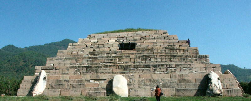
Everything built at Cahokia was a 3D mathematical model, which, by it's dimensions, shape and orientation off north contained multiple tutorials. Each mound was its own separate classroom and this middle-America complex, as a whole, is where the brightest and the best of the nations children were gathered in to receive an intensive education in cyclic astronomy and mathematical principles of positional plotting at sea, for safely traversing the world's oceans. The Cahokia mound complex was an open air university and a Bureau of Standards for the Americas, just like the Giza Plateau was a very ancient Bureau of Standards for Egypt and the Mediterranean, Durrington Walls Henge or Avebury Henge ring and mounds complex were schools for Southern England or Brodgar Ring and its satellite mounds was one for Northern Scotland and the Orkney Islands or the Chinese Pyramids at XI'an, Shaanxl, functioned as an open-air university for the people occupying that region, etc., etc., ... over 5000-years ago.
SO, LET'S START WITH THE DIMENSIONS OF MONK'S MOUND, THE LARGEST ANCIENT STRUCTURE IN NORTH AMERICA.
Over the years there have been many attempts to measure the base dimensions of Monk's Mound and estimates or guesstimates range from 1050' feet of length N-S down to 955'. The E-W length estimates range from 965' down to 774'. In the 1968 report on solid-core drilling of Monk's Mound, Reed et al. gave an approximate north-south dimension of 1,037 feet (316.1 meters), 790 feet (240.8 meters) east-west, and a height of 100 feet (30.5 meters).
In consideration of what occurs at similar complexes on other continents, the base dimensions, as well as side slope angles, will prove to be very important. With such a mammoth construction commitment, no opportunity would have been overlooked, and mathematical codes would have been built into every design feature of the entire edifice. In essence, these huge 3D structures were measurable props used in tutorials, in much the same way as 3D Platonic solids are used in modern classrooms to teach principles of geometry.
Some possible design-stage dimensions that were intended to be clearly measurable on (the now dilapidated) Monk's Mound: