
THE MOUNDS OF OLD ST. LOUIS, MISSOURI, SITTING WITHIN VIEW OF MONK'S MOUND.
Old St. Louis, Missouri sits only 7-miles to the West of Monk's Mound on the opposite bank of the very navigable and long Mississippi River. This grand river is estimated to stretch through middle North America for 2320-miles, from headwaters in Western Minnesota to its outflow into the Gulf of Mexico. Its multitude of tributaries provide waterway routes to many locations over a broad expanse of North America and river silts, periodically deposited over its flood-plain's, ensured ongoing, very fertile areas for abundant agricultural returns.
One of the tributaries to the Mississippi River is the equally huge and long Missouri River, with its headwaters in Montana and joining the Mississippi River at St. Louis, Missouri. This confluence of two major, branching waterways at St. Louis, with links back through the Great Lakes and St. Lawrence Seaway to the Atlantic Ocean, made the geographical position a very important inland centre for the ancient civilisation that built the Cahokia Mound's complex. To the South of St. Louis there is also the massive confluence of the Ohio River and Mississippi River, providing extensive waterway access to the East.
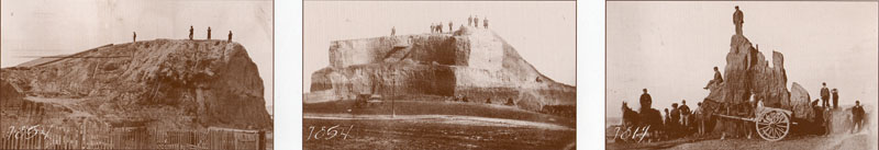
So, we've explored the surviving mounds or known former mound positions immediately around Monk's Mound, but there was yet another "classroom" situated on high bluffs above the Mississippi River and dominated by one singularly huge mound called "Big Mound", or as the early French founders of St. Louis named it, "La Grange de Terre" (The Barn of Earth). This massive mound, although no-where as big as Monk's Mound, was the hub or fulcrum position for the Old St. Louis distribution of mounds and that grouping of satellites sat at coded distances and angles away from the hub position atop Big Mound.
The beautifully symmetrical outline of Big Mound dominated the high bluffs above the Mississippi River when St. Louis was first settled and built. Directly South of Big Mound was a cluster of satellite mounds, including one visually spectacular structure in three tiers or levels. Picture: View of St Louis landscape from the northeast in 1840. Lithograph by John Caspar Wild (Missouri Historical Society collection).
Because of these multiple mounds, Old St. Louis was dubbed "Mound City" and the amazing visual spectacle drew many early visitors to the location, just to see the many mounds in all their splendour. Sadly, in the best traditions of "You don't know what you've got until you lose it", the main grouping of mounds was all but gone in only 25-years, with big mound fully leveled by 1869 (the railway needed fill-dirt). As a final indignity in the name of "progress", the Missouri Department of Transportation is building a bridge right over the former site presently, thus obscuring the position of this vastly important landmark even more.
Now you see it ... Now you don't. The ancient, purpose-built hub position of Old St. Louis, out from which many satellite mounds (bearing special distance and angle tutorials) were precisely positioned. The hub atop Big Mound sat 35640' (exactly 6.75-miles of 5280' each or 6 Scottish miles of 5940' each) from the hub position atop Monk's Mound at a return azimuth angle of precisely 80-degrees. Pictures taken from a poster publication of the Missouri Archaeological Society, September 1998.
The distance of 6.75 miles is in homage to the 24750-mile equatorial circumference of the Earth, of which 675-miles would be 1/36.66666th part (362/3rds).
To recap a very important tutorial about mathematical techniques used in ancient navigation:
The 36.66666 value is simply 1/3rd of 110. The sum of 36.66666' would equate to 1/144th of a 5280' mile. This kind of incremental value was essential to know when doing positional plotting at sea.
If one uses Greek miles in sea legs of travel, the 5250' converts to a circumference of 16500' (1 English league) when 5250' is multiplied by PI @ 22/7ths. This means that the circumference generated from a 5250' diameter is in an "11" family of numbers and each degree of arc is 45.8333333' or 550". Therefore, if one chooses to divide the 16500' circuit up into half, quarter, eighth, sixteenth and thirty-second parts, etc., to get the primary and secondary points of the compass, then an increment of 366.6666' will divide the circle into 45 parts. Each 366.6666' will then equate to 8-degrees of arc or 550" X 8.
This kind of mental manipulation of, what is in reality, whole numbers and fractions, is exactly what the navigator had to be very adept at doing when calculating how far one had traveled in a straight line sea leg before a course change. Making one's way across the vast featureless ocean depended upon both the wind's direction and force, and voyages were made in a series of tacks on the breeze, zigzagging across a leyline towards a destination. Oftimes those angles of tack, back and forth, were quite severe. but the navigator had to stay constantly aware of exactly where the ship sat in the ocean at all times. Sea legs were completed to a whole value of, say, 5 Greek miles or 7 Greek miles (whatever was practicable and achievable without getting too far off course) before a new heading back across the leyline. The length of a leg (in whole Greek miles) was then used as a "diameter" on a plotting board, slate or papyrus map roll and turned into a calibrated "circle". Because the very experienced navigator, knew the boat speed, distance traveled and angle, he was able to accurately plot the latest completed sea leg information in perfect scale, then work out the exact degree angle (using the calibrated circle generated) back to the point of departure and onwards to the destination.
With regards to the return angle from Big Mound to Monk's Mound hub, there would be 4.5 intervals of 80-degrees in a 360-degree circuit or 1/8th of 360-degrees would be 45-degrees of arc. A major tutorial in ancient positional plotting techniques exists in the distance and angle relationship between Monk's Mound and Big Mound.
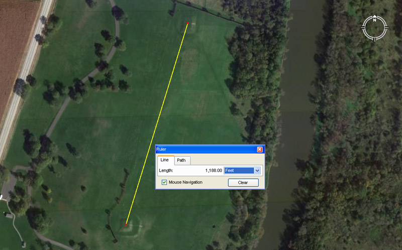
The Aztalan mound's complex in Wisconsin uses the same distance coding, at much reduced ratio, as exists between Monk's Mound and Big Mound. The distance between epicentre positions of the two largest platform mounds is 1188' or 1/5th of a Scottish mile of 5940'. This distance at Aztalan would equate to 1/30th of the 35640' (6.75 English miles of 5280' each or 6 Scottish miles of 5940' each) between Monk's Mound and Big Mound in Illinois/ Missouri. On both sites the coding relates to the equatorial circumference of the Earth under the "11" system of navigation. At Aztalan, the North running azimuth angle is 17.01-degrees and is lunar coding relating to the 6804-day lunar nutation cycle.
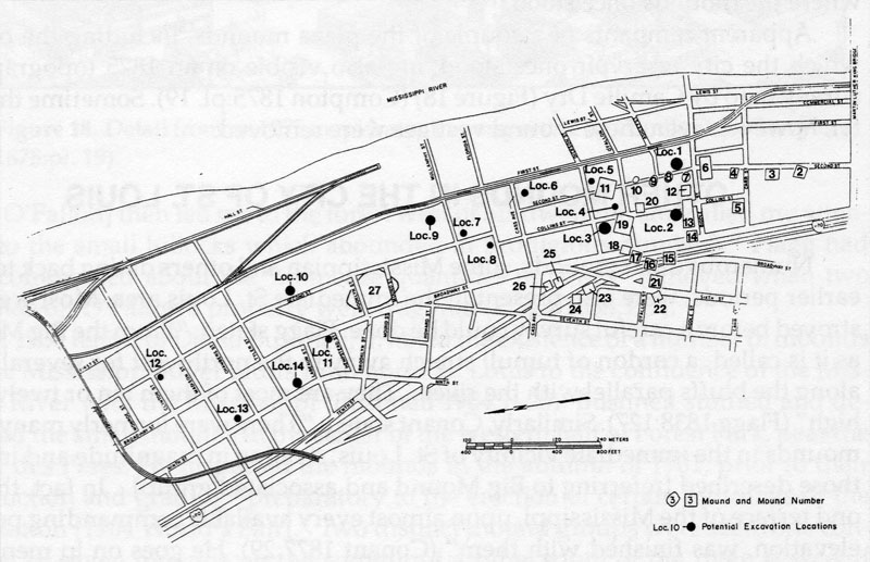
The 1987 Army Corps of Engineer's Map of the St. Louis mound group (Rogers and Pulcher 1987-20) See: The St. Louis Mound Group: Historical Accounts and Pictorial Depictions, by John B. Marshall, The Missouri Archaeologist Vol. 53, 1992.
As a cautionary note, this comment appears on the Missouri Department of Transportation website:
An archaeological survey (Rogers and Pulcher 1987) conducted for the Army Corps of Engineers attempted to test the estimated locations of several mounds; the survey employed a map created for the Museum of Science and Natural History that attempted to place the various mounds within the city grid by simply superimposing Peale and Say’s survey map onto a modern city map. Using this map as reference, limited subsurface testing was conducted; however, no prehistoric deposits were identified. Marshall (1992) notes that the map used by Rogers and Pulcher, while providing a general location of the mound group, is not consistent with mound locations shown on other historical maps of St. Louis in the 19th century; consequently, testing was probably not done at any actual mound locations. With the exception of the Rogers and Pulcher’s survey and testing done for the Cochran Gardens site (Altizer et al. 2005), no professional testing has been done to identify either the mounds or the village associated with the mound group.
Having some faith in the professionalism of a body like the The Army Corps of Engineers and the in-depth historical research that would have accompanied their map-making incentive, let's see what results we get. The locations of many mounds, especially Big Mound, have always been known within the city and the spot was even marked with a boulder monument and brass plaque.
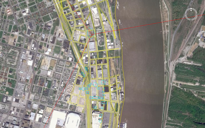
The 1987 Army Corps of Engineer's Map, correctly orientated, showing the Old St Louis mound positions (blue). A red line is seen to come in from the right top of the picture and fall upon Big Mound, situated North of the main cluster. Another red line is seen to run out of frame to the NNW and that line resolves upon a mound position at O'Fallon Park. A red line is also seen to run out-of-frame to the SSW and that resolves onto the only surviving mound of the Old St. Louis group, which is Sugarloaf Mound (with its distance & angle codes still intact).
It's quite obvious, in superimposing the 1987 map onto the Google Earth image, that substantial redevelopment has occurred in downtown St. Louis since 1987, but sufficient of the old streets are still in place and undisturbed to ensure a good fit.
We'll start with the mounds closest to Big Mound and move outwards from there, so the numbering sequence will be a bit topsy-turvey. The position atop Big Mound chosen for the hub position is the spot where it sits exactly 6.75-miles and at 260-degrees azimuth (80-degrees return) from the hub position atop Monk's Mound. On Big Mound, this position is well centred, but slightly South of centre. It is reasonable to assume that when Big Mound was in pristine, original condition that this hub position would have been at the epicentre of a domed or post-marked summit.
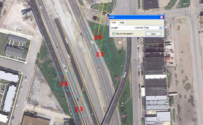
Mounds 23 to 26.
Mound 23 sits 1833.33333' (navigation by the "11" system) from the hub atop Big Mound @ 11.25 (compass)-degrees return.
Mound 24 sits 1728' (navigation, cubic foot in inches, very important multi-use number) from the Big Mound hub @ 14.4 (compass, navigation, multi-use)-degrees return.
Mound 25 sits 1562.5' (navigation) from Big Mound hub @ 9.6 (compass, navigation, multi-use)-degrees return.
Mound 26 sits 1476.5625' (coding half a lunar month) from Big Mound @ 10.5 ("6&" system of navigation, Hebrew reed)-degrees.
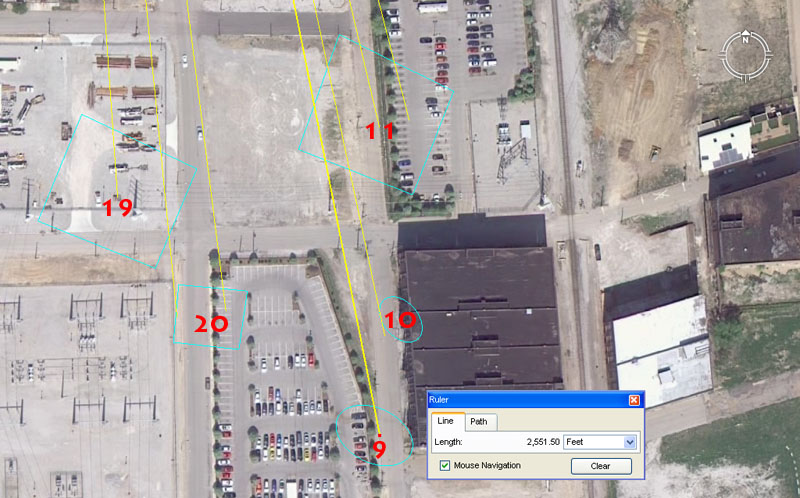
Mounds 9, 10, 11, 19 & 20.
Mound 9 sits 2551.5' (7.2 lunar years, lunisolar calendar count) from the hub position atop Big Mound at an angle of 168.75 (lunar)-degrees.
Mound 10 complies closely to a distance of 2430' (lunar, "6&7" navigation) @ 168 ("6&7" navigation)-degrees, which brushes its western side.
Mound 11 sits 2160' (Precession of the Equinoxes, bushel volume) from the hub position atop Big Mound @ 345.6 (navigation, equatorial circumference)-degrees return. Another reading is an outrunning angle of 166.6666 (3,4,5, triangle, division within decimal progressions)-degrees.
Mound 19 sits 2200' ("11" system of navigation) from the hub position atop Big Mound @ 176 ("11" system of navigation)-degrees.
Mound 20 sits 2362.5' (lunar) from Big Mound hub @ 172.8-degrees (navigation). A return degree angle of 354.375 (lunar year)-degrees would touch its western edge.
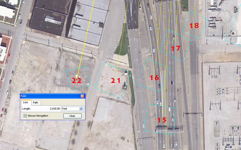
Mounds 15, 16, 17, 18, 21 & 22.
Mound 15 sits 2560' (8 progression, compass) from Big Mound's hub @ 4.5 (compass)-degrees return.
Mound 16 sits 2376' ("11" system navigation, Scottish mile) from the Big Mound hub @ 5.5 ("11" system navigation)-degrees return.
Mound 17 sits 2250' (compass) from the Big Mound hub @ 3.75 (compass)-degrees return.
Mound 18 sits 2178' ("11" system equatorial circumference) from the Big Mound hub @ 2 (multi-use)-degrees return.
Mound 21 sits 2400' (compass, multi-use) from Big Mound hub @ 9 (compass)-degrees return. Also, 180-degrees opposed the angle would be 189 ("6&7" navigation, equatorial circumference, lunisolar Sabbatical Calendar)-degrees).
Mound 22 sits 2430' (lunar) from Big Mound's hub @ 12.5 (compass)-degrees. The merits of 12.6 (Greek foot, Hebrew reed)-degrees would also have been taught.
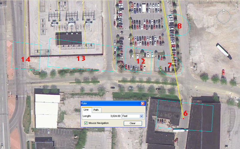
Mounds 6, 7, 8, 12, 13 &14.
Mound 6 sits 3024' (half of 1-minute of arc under the "6&7" system, One perimeter circumnavigation of the Great Pyramid) out @ 350 (7 progression, navigation, calendar)-degrees return.
Mound 7 sits 2835' (strong lunar coding, One perimeter circumnavigation of the Khafre Pyramid, internal length of the Octagon of Newark, Ohio) out @ 170.1(lunar nutation cycle count)-degrees .
Mound 8 sits 2688' ("6&7" system navigation) out @ 168.75 (lunar)-degrees.
Mound 12 sits 2800' (calendar) out @ 172.8-degrees (navigation).
Mound 13 was a special 3-tier mound, so undoubtedly had 3 main codes. It sits out (1) 2800' (calendar) out @ 354.375 (number of days in a lunar year)-degrees, (2) 2750' ("11" system navigation) @ 176 ("11" system navigation)-degrees, (3) 2750' @ 1.1 ("11" system navigation)-degrees.
Mound 14 sits 2750 out @ 180-360 (true North- South) degrees onto one edge, also 1.1-degrees more centrally.
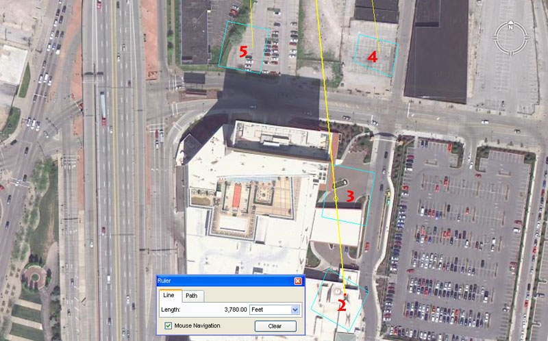
Mounds 2, 3, 4 & 5.
Mound 2 sits 3780' (half the length of the Great Pyramid is 378', "6&7" navigation) from the hub position atop Big Mound @ an azimuth angle of 354.375 (lunar year)-degrees return. Note: Mound 6 of the Cahokia group sits 3780' out from Monk's Mound, whereas mound 10 of that group sits out 3543.75' @ 354.375-degrees.
Mound 3 sits 3564' ("11" system navigation, the distance from Monk's Mound Hub to Big Mound hub is 35640' or 6.75-miles) from the hub on Big Mound @ 354.375 (lunar year)-degrees return.
Mound 4 sits 3240' (navigation, Precession of the Equinoxes) from the hub atop Big Mound @ 352 ("11" system navigation)-degrees return.
Mound 5 sits 3200' (compass) from the hub on Big Mound @ 177.1875 (half a lunar year is 177.1875-days)-degrees.
As more evidence comes in this analysis can be extended to the former mound positions of O'Fallon & Sherman Park's, etc.
MOUND CITY'S LAST SURVIVOR.
In the group of mounds that stood along the bluffs of the Mississippi River, Sugar Loaf Mound is the last survivor (presumably mound number 1). It sits a coded distance of 28125' from the hub atop Big Mound at an azimuth angle of 207.36-degrees.
The 28125' distance is navigational coding and relates to the 24750-mile equatorial circumference of which 281.25-miles would be 1/88th part.
The 207.36-degrees azimuth angle is also navigational and 2073.6-miles would be 1/12th of the 24883.2-mile circumference. The largest Egyptian Royal Cubit was 20.736".
AUTHOR'S SUMMARY.
When I traveled around Middle America in the late 1960's it was general knowledge that the "mounds" were built by the "mound builders" about 5000-years ago. However, in this new, enlightened age of political-correctness, the archaic concepts of "freedom of thought & expression" or "reason based on evidence" are past luxuries, pushed further & further into the background. Nowadays, there are other, more pressing considerations than "warts an' all truth", such as "racial sensitivity" issues and these determine what can and cannot be served up for public consumption. Out of this new, sensitive approach to the dissemination of information there are plenty of ego-stroking misattribution's about history, which are tailored solely to bring pride to the local "indigenous populations". Since the 1960's we seem to have mislaid about 3500-4000 years of North American history and now our school-children are indoctrinated into believing that these great earth structures were put in place by local Indians less than one thousand years ago.
If one goes into the Cahokia Mounds State Historic Site and Cahokia Mounds Museum Society website this following statement appears relative to the mounds complex:
A great civilization of Mississippian peoples thrived at Cahokia long before European settlers came to America. A thousand years ago, this advanced society flourished in the fertile bottomland of the Mississippi River. From the earliest times Native North Americans gradually improved their lives. Each culture handed something of the old and new on to the next.
This is a deliberately vague, ambiguous and misleading statement, designed to draw all focus onto recent-era Indian people as the mound builders (without actually saying it).
Consider the statement: A great civilization of Mississippian peoples thrived at Cahokia long before European settlers came to America ...Well yes, but could you please be a bit more specific? ... Do you mean five thousand years ago?
Then we suddenly jump to: A thousand years ago, this advanced society flourished in the fertile bottomland of the Mississippi River ... Well, that's nice. Glad to know they were enjoying life, but are you saying that's when the mounds were built or are you only inferring that by innuendo?
Then we get: From the earliest times Native North Americans gradually improved their lives. Each culture handed something of the old and new on to the next ... Lovely, heart-rending stuff, but I'm a little lost here. When you say the earliest times, do you mean five thousand years ago when the mounds were built? Are you inferring that there's an unbroken family link, stemming from the present, back to blood ancestors who built the mounds?
Moreover, the Timeline within the website starts in 700AD ... and it looks like the other 3300-years or so got canned for the purposes of the Museum's "political-correctness" & "racial sensitivity" obligations.
Beyond isolationist-dogma, control-freak interference & agendas, vested-interests pushing dumb-down history, lack-lustre scholarship, political-expediency & all that jazz, is there really any valid reason why we're not allowed to know who built the mounds?
So, in consideration of what mainstream-academia is representing as North America's long-term history, based upon archaeological evidence, my final question would be:
How did (circa) 1000 A.D. Indians lay out these giant structures, using known distance and angle codes found on mound complexes of Great Britain, Continental Europe or code-bearing sites around the Mediterranean ... and built 5000 years ago?
Martin Doutré, July 16th, 2011©