THE NAVIGATIONAL CIRCLE AT CIRCLESTONE.
Up until this point the discussion has centred around linear or angle codes
that are reasonably decipherable in the Circlestone layout. Some that relate
to the rising or setting azimuths of the sun are speculative and must be verified
by on-site observation. It's relatively easy to see that the 243-degree winter
solstice sunset, for example, was the intended benchmark, but did it work exactly
to that in practice?
Let's now discuss the intended circumference codes derived from the length
and breadth diameters of the site:
- The distance from A to B across the site was 132 feet internal diameter.
Swanson & Kollenborn describe the walls as being about 3 feet thick, which
means an overall diameter (east-west) somewhere in the vicinity of 138 feet
from outer wall to outer wall.
- The actual diameter sought after was 137.5 feet, or 25 fathoms. The ancient
fathom was 5.5 feet, but was changed to 6 feet in Britain at a very late period
of the Christian era. The distance of 137.5 feet is also 1/120th of a league.
The ancient league was 3.125 miles or 16500 feet. This family of measurement
increments were used from Egypt to Great Britain in antiquity and the pyramids
were built according to them. The Menkaure Pyramid was 259.2 fathoms in base
perimeter and this 137.5 feet diameter at Circlestone is in a ratio of 1:
2.592 against the length of a side on the Menkaure Pyramid (356.4 feet) according
to Menkaure's "11" series navigational assignment. The 259.2 number
relates to 25920-years…the duration of the Precession of the Equinoxes.
- The use of 137.5 feet (1650 inches…80 Egyptian Royal Cubits of the
"11"-series @ 20.625 inches each) is for mnemonic reference to the
most commonly used method of transoceanic navigation in antiquity. Linear
distances were calculated in leagues or indeed parts thereof. The "11"
series family of measurements included: leagues (16500 feet), miles (5280
feet), furlongs or furrowlongs (660 feet), chains (66 feet), rods/ perches
(16.5 feet), fathoms (5.5 feet) & links (7.92 inches). The progress of
a ship at sea would be very carefully monitored as to direction and speed
and when a major course change occurred the former straight-line heading would
be calculated out on the plotting chart according to leagues covered (note:
If there were more frequent, short distance course changes then the chosen
increment could be "fathoms"…a popular increment used was 100
fathoms or 550 feet converting to plotted circles of 1728 feet or 4.8 feet
of arc per degree).
- A linear distance (diameter) of 1 league (16500 feet) creates a circle of,
essentially, 51840 feet. The angle of each face of the Great Pyramid is 51.84-degrees.
The Great Pyramid (72 reeds per side) covers a base area of 5184 square reeds
(of 10.5 feet each). In Egyptian "pyramid acres" of 28800 square
feet each (identified by Herodotus) the 4 faces and base of the Great Pyramid
accumulate into 51.845 pyramid acres. The azimuth angle that the Octagon,
geometric earth-mound complex of Newark Ohio lies on is 51.84-degrees. 51.84
is 1/500th of 25920…the ancient number used to describe the duration
of Precession in solar years. Because the outer diameter (east west) of Circlestone
achieves 1650 inches, it creates a coded circumference of, essentially, 5184
inches. This mathematical principle would have been used to teach navigation,
the size of the Earth and how to grid reference it for safe traversal.
- Whereas the league linear distance is based upon the number 11, the circumference
it creates is sexagesimal and can be easily broken down into degrees and minutes
of arc. This is how ancient navigators did positional plotting, as linear
distances travelled were based upon the 11 series numbers, converting to a
circumference wherein it was easy to determine an accurate degree angle. Each
course change translated into a new plotting circle on the chart and it was
easy to keep track of the angle back to the point of departure or onward to
the destination.
- The diameter of 137.5 feet creates an intended or coded circumference of
432 feet (to a shortfall error of .36 of an inch…about 1/3rd of an inch).
It seems apparent that ancient navigators used a very slightly modified form
of PI in order to achieve perfect numerical values in the circumference…diameter
X 3.141818182. The Great Pyramid (756 feet per side…3024 feet for a full
circuit) is 432 Celtic Royal Cubits per side (@ 21 inches each) in length
according to its sexagesimal assignment. It was also symbolically read as
756.25 feet per side under its "11" series or "fathom"
assignment (3025 feet for a full circuit). The 432 feet circumference at Circlestone
could be viewed simultaneously as 1/302400th of the "ring of the Earth"
under the sexagesimal measurement standard or 1/ 302500th of the "ring
of the Earth" under the "11" series measurement standard.
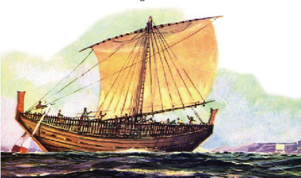
Figure 13: Sturdy, durable cargo vessels like this Phoenician "round ship"
are positively known to have transported tin from the mines of Cornwall, England
back to the eastern end of the Mediterranean from 1350 BC. Similar mining operations
were being carried out on the northern shores of Lake Superior, where an estimated
500,000,000 pounds of copper were extracted in antiquity…none of which
stayed in America. Evidence would suggest that the copper was transported back
to the Eastern Mediterranean. Similar mining operations were being carried out
at the far reaches of the globe…like at Sarina Beach, North Queensland,
Australia, where mining, smelting of ore and building of a quay for loading
ships took place. A similar smelter was recently found in Oklahoma (see
www.viewzone.com ), then quickly covered by government bulldozers. It
is very apparent that ancient ships were ranging all over the world in search
of resources for thousands of years before the Christian era. The mathematical
concepts found within ruined ancient structures like the pyramids or Stonehenge
attest to the fact that ancient civilisations had a perfect knowledge of the
size of the Earth and how to grid reference it for successful navigation to
any point of the globe.
In the very near vicinity of Circlestone observatory is purported to be, "The
Lost Dutchman's Mine". Was a group from the Eastern Mediterranean or Europe
undertaking mining operations in Arizona's Superstition Mountains? Was Circlestone
Observatory set out so that the mining colony could always remember and teach
astronomical/ navigational principles that would ensure safe passage back to
their former homeland? The "very standard and expected" mathematical
layout of the Circlestone site would suggest that this was the case.
THE SABBATICAL CALENDAR CIRCLE AT CIRCLESTONE.
Ancient astronomer mathematicians built sites like Circlestone as repositories
of codes and places where initiates to the astronomical arts could be taught
the age-old principles. These initiates were the brightest, most adept children
who were set apart as the "few to bless the many". Their task was
to learn, preserve and use the great knowledge for the benefit of regional society
and their responsibility extended to teaching many others during the course
of a lifetime of service.
It has been mentioned that there was a north-south diameter at Circlestone
of 136.08 feet and that it coded the 6804-day lunar nutation cycle in its radius
(68.04 feet). The "customised" circle produced from this diameter
was used to calculate the calendar. Before proceeding with a full explanation
of how this circle worked it's necessary to first comment upon various ways
that the ratio PI was used or manipulated in antiquity for the creation of workable
mnemonic codes.
- PI is an unresolvable ratio between the diameter and circumference
of a circle that approximates 1 to 3.1416. Depending on what the ancient
astronomer/ mathematicians were doing, pure PI or variations of PI in differing
degrees of perfection could be pressed into service.
- The inner Sarsen Circle at Stonehenge was read as 100 feet of diameter.
This was achieved by a PHI reduction of the Aubrey circle @ 288 feet
diameter ÷ 1.6180339 = 178 feet ("Y" Holes Circle) ÷
1.6180339 = 110 feet (the outer rim of the Sarsen Circle). The lintel stones
that sat atop the standing sarsen stone uprights were 5 feet wide, so we deduct
10 feet to get the inner sweep figure = 100 feet.
- If the inner diameter of the Sarsen Circle were read as 100 feet then the
circumference must literally be 314.16 feet in a pure PI rendition
(100 feet X 3.1416).
- The inner sweep circumference was also symbolically read as 315 feet
(100 feet X 3.15) or ½ of a Greek Stadia. This equated to 30 reeds
of 10.5 feet each (remember…there were, literally or symbolically, 30
lintel stones… so the inner face of each was 1 reed of 126 inches).
- The inner circumference sweep was also symbolically read as 312.5
feet or 1/52.8th of a league. Under the "league" or "11"
series navigational system the Earth was grid referenced to be 7920 leagues
in circumference and 7920 miles in diameter. There were 3.125 miles in an
ancient league.
- When seeking to create perfect whole numbers on a circumference for navigating
according to the "11" series of increments the rendition of PI @
3.141818182 was pressed into service. There was also a septimal rendition
of PI used when converting some sexagesimal/ septimal value diameters (like
the popular number 42) into dynamic whole number circumference values…like
42 X 3.142857143 = 132.
- The use of these various pseudo-renditions of the PI ratios in varied types
of calculations made the systems very fluid and easy to work. In some instances
it was essential to use a perfected form of PI, but when doing "mathematical
progressions" in the "6", "7" or "11" series
of numbers these other near ratios were substituted for PI.
Having clarified the issue of PI usage in various guises, let's now consider
how the 136.08 internal length of Circlestone was converted to a dynamic Sabbatical
Calendar value. This occurred by using the ratio 3.125, thus rendering the
136.08 feet diameter as a circumference read as 425.25
feet.
WORKING THE CALENDAR.
The ancient Sabbatical calendar was lunisolar, which meant it tracked both
the Sun & Moon simultaneously. It also worked to a "raw count system"
using weeks of 7-days, months of 28-days with 13 months per year (364-days)
that ran undisturbed for 7 solar years before it was fully corrected during
a festival.
- The Sabbatical Calendar worked simultaneously in tracking 7.2 lunar years
(2551.5-days) alongside 7 solar years (2556.75-days). For accuracy in commencing
the calendar day count the winter solstice (midwinter) was observed, then
the count of days was moved 1/8th of a solar year backwards to the beginning
of winter. The formula for this was 40.5 days plus 5.25 days = 45.75 days
(46) back from the winter solstice. From that point in time the calendar
count of days was 2592 days until the end of the first Sabbatical period of
7 solar years. This method was more scientific and precise than the "raw
count" method and was used by the priests for making accurate calculations
related to milestones arrived at within the Sabbatical Calendar system.
- The count of 2592 days could be done in various ways, including batches
of 40.5 days, 81 days of 162 days. At Circlestone the winter solstice sunset
is clearly coded to occur at 243-degrees. Back from that position at 202.5-degrees
is the most prominent spoke still in existence. Swanson & Kollenborn state
that its orientation or degree angle out from site centre is, 'S 23 W'
or 203-degrees. It would have been the intention of the observatory designers
to mark 202.5-degrees true from north by this spoke, as it's then 40.5-degrees
away from the winter solstice set position. This was for mnemonic reference
to counts within the Sabbatical calendar in batches of 40.5-days. There would
be 64 batches of 40.5 days in 2592 days. The 202.5-degrees X 2 would equal
405.
- Swanson & Kollenborn state that the other spoke, still clearly in evidence,
extends out on an angle of, 'N 80 E' (80-degrees azimuth). Kollenborn's
drawing depicts this spoke as somewhat more curved, tumbled or dilapidated.
The angle that the ancient builders would have intended to achieve with this
spoke was 81-degrees, which is 2 X 40.5. This is verified by the number of
degrees difference between the 243-degree winter solstice position and the
81-degree position, which is 162-degrees (81-degrees X 2). The 40.5-day increment
was very important in the 2592-day count and it is for that purpose that it
was so strongly marked in progressions of spokes or the winter solstice position
at Circlestone.
- A very important mathematical progression related to the lunar cycle exists
in the difference between the 202.5-degree spoke position and the 81-degree
spoke position. This difference is 121.5-degrees. If this value is multiplied
by 2 then the result is 243…the same as the degree angle anchor or benchmark
point chosen to indicate the setting position of the winter solstice sun at
the latitude of Circlestone.
- Not wishing to confuse the issue at this point, it should be mentioned that
the 81-degree position also coded 80.901695-degrees in mnemonic reference
to ½ PHI (.80901695). The numbers 40.5, 81 & 162 are all coded
expressions for "rounded" PHI. True PHI is 1.6180339. The ancient
Megalithic rod measurement (2.5 Megalithic Yards) had a true length of 80.901695
inches.
- Another way of making calculations within the Sabbatical calendar was to
count directly from the winter solstice for 7 solar years or 2556.75-days
(365.25-days X 7). The ancient Druids used to hold a "mistletoe culling"
ceremony on the sixth day after the full moon following the winter solstice.
This was purely for the purpose of achieving a 5.25-day offset (6th-day) between
the period of 7 solar years (2556.75-days) and 7.2 lunar years (2551.25-days).
- The Sabbatical Calendar circle at Circlestone was, as stated, 425.25 feet
in circumference (136.08 feet X 3.125). This equates to 5103
inches or 2551.5 inches X 2. In other words, each two inches of
the circuit of 5103 inches represented 1 day in the 354.375-day lunar year
and 7.2 such years equated to 2551.5-days. The circuit
of 425.25 feet at Circlestone is 1/6th of 2551.5.
- Ancient Druids and other predecessor priests used their "reed"
rods for calculating intervals within the Sabbatical calendar. This is because
2556.75-days (7 solar years) or 2551.5-days (7.2-lunar years) are expressions
of 5.25-days and the reed ruler was 10.5 feet or 5.25 feet X 2. It's quite
obvious that for convenience the calibrated staffs of the ancient priests
would have been in ½ reeds of 5.25 feet. For calculating intervals
within the Sabbatical calendar each ½ reed represented 5.25-days and
486 (243 X 2) such periods equalled 7.2 lunar years (2551.5-days) whereas
487 such periods equalled 2556.75-days (7 solar years). For a full explanation
on how the ancient Sabbatical Calendar worked see the article devoted to The
Calendar of Coligny within this website.
The 425.25 feet circuit code provided all of the essential knowledge for staying
abreast of both solar and lunar positions within the 7 X 7 years of the Sabbatical
calendar system. It simultaneously worked for calculating daily lunar positions
within the 6804-day lunar nutation cycle. The sum of
425.25 is 1/16th of 6804.
CIRCLESTONE'S RING OF THE EARTH CODE IN GREEK STADIA'S OF 630 FEET (60 REEDS).
We have discussed the means whereby the 136.08 feet north-south internal measurement
was converted to a coded circumference using the ratio of 1 to 3.125…the
same ratio for converting miles to leagues.
We will now convert the 132 feet (east-west) diameter to its coded circumference
by using the navigational rendition of PI @ 3.141818182. This achieves a perfect
whole number when "11" series linear distances (like 132) are converted
to sexagesimal circumferences to be broken down into degrees, minutes and seconds
of arc (with a second of arc being 1/360th of a degree).
The "11" series diameter circles can be broken down equally as well
into 320th parts and reduce in 40th parts through two stages thereafter in a
similar manner as minutes and seconds of arc reduce sexagesimally.
- Circlestone's "11" series east-west diameter of 132 feet X 3.141818182
= 414.72 feet.
- The ancient method for determining the sexagesimal circumference of the
Earth was to take the base perimeter value of The Great Pyramid (3024 feet…½
a degree of arc for the world) and multiply this by 43200 = 130636800 feet
or 24741.81818 miles. This value could then be read in several different measurement
increments including stadia of 630 feet, much used by the late era Greeks
who got their measurement system from the Egyptians.
- The Earth circumference of 130636800 feet ÷ 630 feet (1 Egyptian/
Greek stadia) = 207360…and in terms
of ½ stadia at 315 feet this equates to 414720.
- The inner Sarsen Circle at Stonehenge was coded to represent 315 feet of
circumference or ½ a Greek stadia (30 reeds).
- The distance from the centre of the circle embankment at the Octagon of
Newark, Ohio to the "Great Circle" across the city is 6300 feet
(10 stadia). This distance is 1/20736th
of the "ring of the Earth" under the sexagesimal geodetic reading.
- Not wishing to confuse the issue, it must be pointed out that the ancient
astronomer/ navigators knew that there was a small degree of error in their
"ring of the Earth" totals for both the sexagesimal and "11"
series geodetic systems. They used these near perfect systems because of the
way they reduced mathematically into small divisions, but at the same time
knew the true equatorial circumference of the Earth to about the same number
we use in modern times.
- The means used anciently for remembering the size of the Earth in miles
was to use Egyptian Royal Cubit rods and apply a simple formula to their lengths
in inches to get a reading in miles. Thus the sexagesimal rod of 20.61818182
inches X 1200 = 24,741.81818 miles. The "11" series rod of 20.625
inches X 1200 = 24,750 miles. There was however another, slightly longer rod
in use that equated to 1.728 feet or 20.736
inches and this rod, multiplied by 1200 = 24,883.2 miles. This is a shortfall
on the equatorial circumference that we use today by a mere 18.8 miles.
- The 414.72 feet circumference circle created by the east west diameter of
132 feet (X 3.141818182) is 1/315000th of the "ring of the Earth"
under the sexagesimal system or 1/316800th of the "ring of the Earth"
under the ancient full size equatorial reading. The internal width measurement
of the Calendar of Coligny bronze plaque is 31.68 inches or 2.64 feet.
THE OTHER ID & OD CIRCLE CODES.
In the book, Circlestone, A Superstition Mountain Mystery, Swanson
& Kollenborn write, 'Circlestone is not a "perfect" circle,
the diameter measuring 133 feet at most points but 140 feet at one tangential
point…The entrance to the circle is 3 feet wide, the average width of the
wall measures 3 feet, and the height of the existing high point of the wall
is 5½ feet. The center structure within the circle is 17 feet square'
(pg. 67).
The 133 feet of internal diameter for "most points" was intended
to convey a true circumference of 420 feet or 5040 inches.
The "140 feet at one tangential point" was intended to convey
a circumference of 440 feet or 5280 inches.
The "17 feet square" central structure was coded to convey
17.01 feet per side or 68.04 feet for the full perimeter in remembrance,
once again, of the lunar nutation cycle @ 6804-days.
Both the 420 feet & 440 feet values are derived directly from the
"flat floor" altar atop the Great Pyramid and are universal codes
for world navigation using two varied systems… one based upon a sexagesimal/
septimal series and another based upon an "11" series.
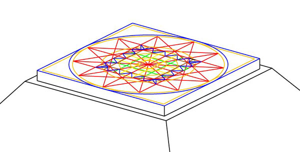
Figure 14: The assumption is that the Great Pyramid once had a pointed top,
but it was lost, discarded or dismantled at some point of history. The fact
is that it has never been known to have a pointed top throughout its long recorded
history and it is evident that it was deliberately built to have a flat floor
altar sitting atop it. Trigonometry dictates that the square altar had to have
sides 44 feet long. Seven PHI reductions of the pyramid's PHI assigned base
length achieve the value of 42 feet. It is evident that the numbers 44 &
42 were prominently represented atop the Great Pyramid and that both relate
to navigation or calculating the size of the Earth under the sexagesimal, septimal
and 11 series systems of numbers. The trigonometric opportunities allowed for
a terrace, set 3 feet lower than the altar, upon which the astronomer priests
could work. The altar appears to have functioned as a "plane table",
for accurately viewing (across the expanse of the table to the opposite edge)
the alighting positions of stars out to all 4 quarters of the Earth. Calibration
marks on the table edges would have allowed for accurate degree angle calculations
of daily stellar positions.
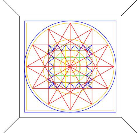
Figure 15: There is a layered geometric system of star and cross pattern
geometry found on sites like Rennes Le Chateau in Southern France or at the
Crosshouse of Miringa Te Kakara in New Zealand. It's also inferred at Stonehenge
or the Octagon of Newark, Ohio. The above picture is a final abbreviation of
the standardised layered geometry, based upon the earliest "zodiacs"
found in the east or pictorial elements found upon the Egyptian Hypocephalus
funerary amulet. A full assessment of the external and internal measurements
of the 3 main pyramids shows that they were set up as a "World Bureau of
Standards of Weights, Measures, Volumes, Angles, Navigation & Astronomical
Methodologies". In the above picture 2 outer circles and 2 outer squares
are shown (blue and yellow sets). The blue set extends to the altar's edge (44
feet diameter). The yellow set extends to within a foot of the altar's edge
(42 feet diameter). Both sets constituted dynamic values used in world navigation.
Although the Great Pyramid is in a ruined state, its eternal geometry dictates
exactly what it was capable of coding mathematically. These codes were, in turn,
dispersed to all parts of the globe and are strongly represented in sites like
Circlestone.
- The 420 feet circle provided a calibrating opportunity atop the Circlestone
wall, wherein every 14 inches equated to 1-degree of arc. An observer situated
at the centre of the site could watch stars descend and alight upon the outer
wall, which acted as a "false horizon". The central observer would
call out, "left or right" instructions to another individual, working
from the wall's exterior, to place a small stone marker atop the wall where
the descending star precisely hit the wall. By measuring from N, S, E or W
around to the stellar alighting position in increments of 14-inches (1/9th
of a reed) accurate star angles could be monitored seasonally. This calibration
would have been to the inner edge of the wall.
By using the 420 feet circuit as 320 increments (positions) instead of 360,
the length of each increment would be 15.75 inches. This is ½ of 31.5
inches or ¼th of 63 inches, which are reed or stadia values. By using
this calibration on Circlestone's inner ring many accurate geodetic or lunar
calculations were possible and indeed the progress of the moon throughout
its 6804-day lunar nutation cycle was rendered quite simple to follow mathematically.
- The 420 feet circumference circle could also be used in increments of 7,
14, 28 or 56 to make calendar calculations in a "raw count" of the
Sabbatical calendar, using increments based upon increases of 3 inches. The
circumference could also be used for calculations within the 2551.5-day (7.2
lunar years) or 2556.75-day (7-solar years) Sabbatical calendar periods.
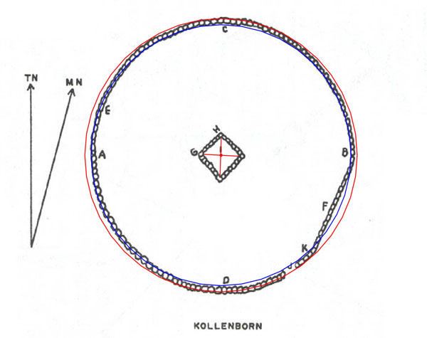
Figure 16: This is what overlaying circles of 420 feet circumference (blue)
and 440 feet circumference (red) would look like on the Circlestone site. Regardless
of the deliberately inbuilt meandering nature of the circuit wall, accurate
calibration marking was still easily accomplished. It's probable that at the
time of construction a series of painted marks were included (probably using
different colours) on the inner and outer rims of a very flat-topped wall surface.
The heaped and irregular state of the top of the wall in modern times in no
way represents how it would have looked when in its former pristine condition.
- The 440 feet circumference is a navigational coding under the "11"
series geodetic system and 440 feet represents 1/297000th of the "ring
of the Earth" under that system. The circumference of 440 feet (1/12th
of a mile) is also 5280 inches…used for mnemonic reference to the 5280
feet in a mile.
- Calibration lines running across the top of the wall from the inner rim
circle of 420 feet circumference would divide this outer rim circle into 360-degree
and 320-part calibrations. A 360th part of this outer circuit would be 14.6666
inches (14 & 2/3rds inches). The 440 feet circuit breaks down very effectively
into 320th parts, with each representing 16.5 inches (1/12th of a rod or perch…16.5
feet). Innovative readings of this circle would keep in memory the "11"
series family of measurements of league, mile, furlong, chain, rod/ perch,
fathom and link.
MEASUREMENTS OF AREA AND THE 11.52 CODE.
The Circlestone site has a very interesting "straight section of wall"
feature built into, which codes both a linear distance and an angle. By working
across a carefully scaled plan, based upon Tom Kollenborn's measurements (which
might well be based upon a topographical photograph) the "best guess"
length of this straight section of wall is 44 feet. This would make very good
sense, inasmuch as it could also be symbolically read by the builders as 43.2
feet.
The wall section is on an azimuth angle of 25.2-degrees, which is one of the
most dynamic codes of antiquity.
The straight section of wall infers a rectangle, stretching across the site
to touch opposite wall positions. Let's reconstruct what this rectangle would
look like and analyse its significance in carrying codes of area.
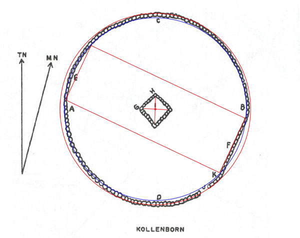
Figure 17: A rectangle is created based upon the length of straight wall
section and how it relates in distance to a 90-degrees opposed position across
the site, wall to wall. The upper line of the rectangle runs for 125 feet to
touch the wall with relative perfection. The width of the rectangle is 44 feet.
In this instance both length and breadth of the rectangle are fractions of the
"11" series league of 16500 feet. The length of 125 feet is 1/132nd
of a league and the length of 44 feet is 1/375th (½ of 750) of a league.
- In terms of a square footage area code the 125' X 44' rectangle achieves
5500 square feet. The 55 or 550 number was much used in ancient navigation.
One very popular circumference encrypted into sites around the world is 1728
feet. This circumference is based upon a diameter of 550 feet and 55 was a
foundation number for the creation of both Silbury Hill in Southern England
and the Crosshouse of Miringa Te Kakara in New Zealand. It was also the base
linear distance number used at Le Ménec (Carnac) in the layout of the
1100 stones there.
- The top and bottom lines of the rectangle lie on azimuth angles of 115.2-degrees.
Each face of the Great Pyramid was intended to code 230400 square feet or
115200 square feet X 2. The Menkaure Pyramid has an area, incorporating all
sides and its base, of 11.52 Pyramid acres of 28800 square feet each (the
area of the Egyptian Pyramid Acre was identified by Herodotus after consultation
with Egyptian Priests… based upon 8 pyr. acres per face of the Great
Pyramid).
- The 11.52 code was used for fully refining the solar year to 365.2420-days.
The heliacal rise of Sirius was observed to produce a calculable period of
365.25-day intervals. It was known to ancient astronomer/ priests that this
period almost perfectly described the duration of a solar year, but 11.52
minutes then had to be deducted to achieve 365.2420-days.
- Although the rectangle (probably) literally complied to 44 feet of width
and 125 feet of length, the astronomer/ priests would also have coded it to
be read as 43.2 feet X 126 feet (12 reeds) to mean 5443.2 square feet. This
is a very strong lunar code and 5443.2-days is in a ratio of 1.25 to 1 against
the 6804-day lunar nutation cycle. A length of 5443.2 feet is 1/24000th of
the "ring of the Earth" under the sexagesimal geodetic system.
- It's also likely that the straight stretch of wall symbolically represented
43.56 feet (the Saxon acre was based upon 1 furlong of 660 feet X 1 chain
of 66 feet = 43560 square feet. Other symbolic readings or calibrated markings
would have included 45 feet and very importantly, 45.36 feet (the height of
the Great Pyramid under its sexagesimal geodetic assignment was 453.6 feet.
This describes the height to the top of the altar flat floor. It is from this
sexagesimal series number and other close proximity numbers, under PHI and
"11" series assignments, that Egyptian Royal Cubit rulers were derived.
The 453.6 number is central to a formula for calculating the size of the Earth
and how to grid reference it for successful navigation.
- Other likely square footage dimensional codes for this region include 40.5
X 128 (5184…navigation) or 43.2 X 125 (5400…lunar calibration system),
etc. Width codes extending to 48 & 48.6 feet respectively appear to have
been used by the priests and taught to initiates. Length codes used in conjunction
with the width codes probably ranged from 120 to 132 feet respectively.
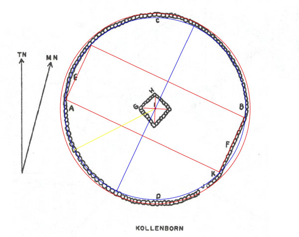
Figure 18: At Stonehenge there is a coded rectangle known as the "Station
stones" rectangle, which served as a very exact surveying pattern leading
to the accurate construction of Stonehenge. The builders of the Circlestone
site appear to have used a variation on the same approach, starting with a carefully
coded central rectangle. Let's identify some final attributes.
- The yellow line in the above picture extends to the 243-degree position,
which was chosen as the anchor position for the site. This should visually
be either the true winter solstice set position or very close to it depending
upon the height of the distant horizon. The 243-degree position was most certainly
a surveying benchmark.
- Moving around anti-clockwise 37.8-degrees we encounter a blue line at 205.2
degrees - 25.2-degrees, which runs 90-degrees opposed to the central rectangle's
length. The 37.8 code relates to the Great Pyramid, where ½ its base
length was 378 feet. The 25.2 code also relates to the Great Pyramid, where
1/3rd of its base length was 252 feet. Remember, the 202.5-degree position
represents a "spoke" extending from site centre to the perimeter
wall.
- The degree distance from the 205.2 position to due east at 90-degrees is
115.2-degrees…indicating the 11.52 code strongly once again.
- The degree distance from due east at 90-degrees to the 25.2-degree position
is 64.8-degrees. This is a very important ancient code and a part of a numerical
progression describing the duration of the Precession of the Equinoxes at
25920-years. The value of 64.8 is ¼th of 259.2. One of the 8 major
embankments of the Octagon of Newark, Ohio was set to an azimuth angle of
64.8-degrees and all 8 embankments of the octagonal component of the Octagon
earthworks were in a progression of numbers based upon 64.8-degrees.
EPILOGUE.
On the 3rd of December 2001, I was getting on with a research project when
I received a "whirlwind" visit from a pseudo-hippy stranger called
Jeff, a self described Druid-Shaman, seemingly fresh in from Arizona.
He assigned me the task of "solving" Circlestone, on behalf of his
American Indian colleagues. He then layered me with maps and a tattered book
with several pages missing, did Hopi incantations on my back step, put a greenstone
pendant around my neck and told me I was initiated into his druidic order.
After he'd left and I'd recovered, I had a look at the odd assortment of materials
he'd given me to work with and was immediately drawn to the Circlestone site
because of its size and the obvious laborious effort expended in its construction.
The research materials were fragmented and it was initially difficult to assess
whether or not I had enough to proceed with any form of realistic analysis.
I also had 3 large research projects in the works, so Circlestone would have
to go on the backburner till late January 2002.
I would like to thank George & Audrey Delange of Phoenix, Arizona
for coming to my aid and supplying missing materials, which allowed this analysis
to proceed.
Having lived in several of the South-western States and being the son of a rancher
from Spring Valley Nevada, I have a particular affection for that large and
picturesque region of the United States.
It is my sincere hope that this analysis will be of assistance to Jeff's
American Indian colleagues and to all researchers of ancient sites scattered
throughout the southwest…task half completed…
Martin Doutré (Druidic Inferior Rhymer).
Auckland, New Zealand. January 31st, 2002.