THE MEASUREMENT STANDARD.
Up until this point we have demonstrated coded astronomical, surveying and PHI relationships using nothing more than azimuth angle data, or comparative dimensions within the Crosshouse itself. It is now time to consider the measurement standard that was employed in the construction of the Crosshouse and the intention of the builders to encrypt particular numbers by use of that standard.
Oral traditions tell us that the Crosshouse at Miringa Te Kakara had a pedigree
that extended back many centuries before colonization and that the structure
had been subjected to many rebuilds over time.
From this we can deduce that the measurement standard found within the Crosshouse
was not influenced by the coming of Europeans in the early 1800's. Indeed, the
attitude of Pao-Marire was to keep colonial influences at bay, never embrace
them, but preserve the "old ways" in this isolated hamlet at the heart
of the North Island.
Inasmuch as a "measurement standard" takes on sacred significance
and becomes the subject of veneration as it is handed down to ensuing generations,
we must assume that the Crosshouse was originally built to a very old, pre-colonial
"measurement standard". In keeping with what traditionally happened
amongst civilizations all over the ancient world, the measurement standards
were guarded and kept true by the priests of regional societies. Let's now endeavor
to identify the ancient New Zealand standard:
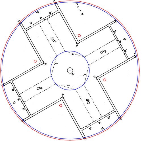
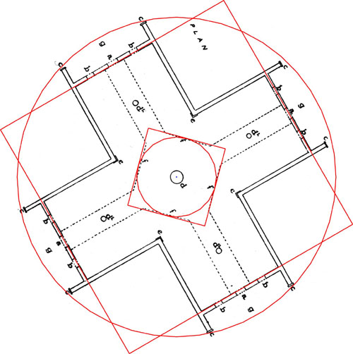
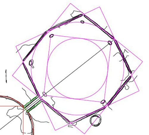
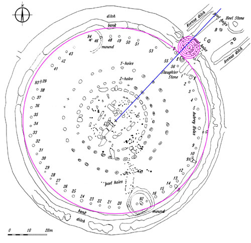
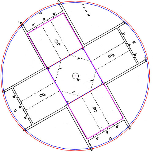
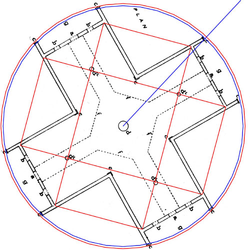
A central circle is created, which extends to the position where the centre platform ends and the walkways leading to the doors begin.
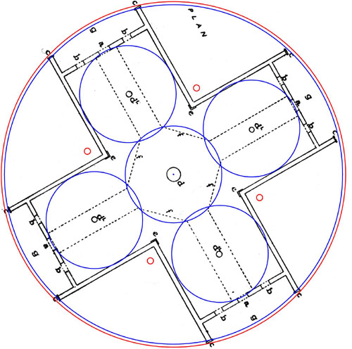
Four circles of the same size are centred upon the secondary posts and it is seen that they designate the internal width of each wing. They also extend to the doorway thresholds, indicating an intention to encode this diameter, but to make the length of each wing somewhat less than 3 of these diameters. The circles shown have diameters of 15.708 feet and this is a numerical expression of ½ PI @ 1.5708 or full PI @ 3.1416. This indicates that the measurement standard used at Miringa Te Kakara was, most definitely, the (so-called) British Standard of measurement, as the intention was to divulge the specific numbers associated with the PI ratio. This concept can be further tested within the Crosshouse.
Although this researcher detected a slightly lesser radius dimension (a
few inches) in the placement of the ruined secondary post stubs during the survey
of 1/7/2001, it must be assumed that architect, C.G. Hunt was advised by the
Pao-Marire elders that the secondary posts were intended to correctly reside
at the above marked positions. If this is so, the rear of each secondary comes
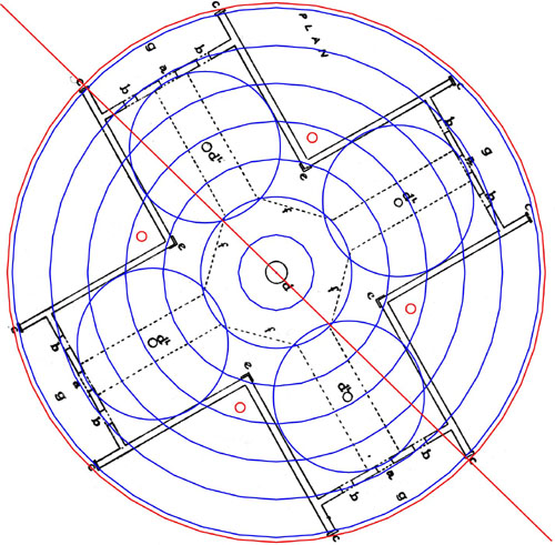
to within a very close tolerance of coding PI @ 31.416 feet. Let's however test
this PI coding throughout the Crosshouse in increments of 3.927 feet increases
(1/8th of 31.416). The red line running diagonally upward to the left
is seen to perfectly brush the edge of the end plate of the building. This angle
is 314.16-degrees, again positively coding PI.
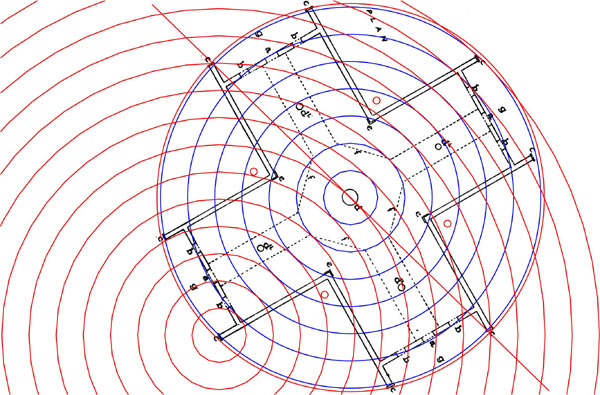
It is clear that the British Standard of measurement was used to encrypt the coded values of the Crosshouse, as it's PI representation is consistent within the 55 feet encasing circle to a tolerance of 1/4th of an inch, or about 7 millimeters. Knowing that the British/Egyptian/Sumerian/Babylonian Standard was used, let's extract the codes.
INTERNAL CODES OF THE CROSSHOUSE.
It has been demonstrated that the PHI ratio featured prominently in astronomical
mathematical methodologies from continent to continent in antiquity. Alexander
Thom's "Megalithic Yard", derived by a series of averaged measurements
within the Sarsen Circle at Stonehenge, would be a PHI ratio, expressed in British
standard inches if decreased a mere .277 of an inch to 32.360678 inches (PHI
X 2).
A little understood fact is that the sexagesimal British Standard of Measurement
is, in large part, an expression of "rounded PHI" (1.62) rather than
pure PHI (1.6180339). Both pure PHI and rounded PHI measurements were encrypted
into The Great Pyramid, as well as the Crosshouse at Miringa Te Kakara.
The builders of the Great Pyramid incorporated 3 separate readings in the Pyramid's
length and height codes, two of which we will mention now. The length could
be read as 280 megalithic Yards (32.360678 inches), culminating in a finished
length of 755.0824867 feet. It could also be as 280 "rounded" Megalithic
Yards of 32.4 inches each (756 feet…literal design length). This length
was also 440 Royal Cubits (An Egyptian Royal Cubit in the Turin Museum collection
is 20.618 inches). It has been a point of considerable debate as to the standard
length of a ERC…in fact there have got to be at least 4 different lengths,
ranging from 20.593" to 20.736", with the most commonly used ones
being 20.618" & 20.625".
Under a standard rule of 3,4,5 triangulation, the "opposite" is 1.25
less than the "hypotenuse" and the adjacent is 1.6666666 less than
the "hypotenuse". Using the 3,4,5 formula for determining an "adjacent",
the height of the Great Pyramid to the top of it's flat floor altar is determined,
when the base length is considered as a "hypotenuse" value. Therefore:
755.0824867 feet ÷ 1.66666666 = 453.049492 feet. Alternatively, 756 feet
÷ 1.6666666 = 453.6. The present ruined structure is about a foot shorter
than this. These same important values, which relate directly to world navigation,
are found within the Crosshouse, albeit at 10% of the Great Pyramid readings.
This is how they are coded:
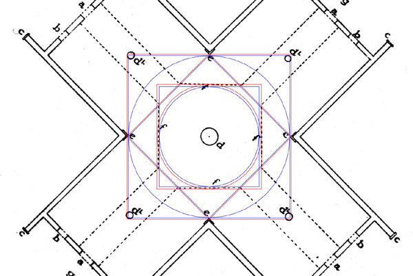
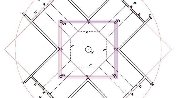
In the above picture the outer circle shown is 56 feet in diameter. It's
overlaying square (½ PHI reduced) is 45.3049492 feet (or 1/10th of the
height of the Great Pyramid under its pure PHI assignment). A second witness
to the intention of coding the "height of the Great Pyramid" within
the Crosshouse is found mathematically by consideration of the central square,
formed by the convergence of the walkways. This was regulated to 14 feet of
diameter… and 14 feet X double PHI (3.2360678) = 45.3049492 feet.
It has been mentioned that under the Egyptian/ British system of measurement
a "rounded PHI" (1.62) increment appears to be prominent and there
would be 560 "rounded PHI feet" in the length of the Great Pyramid.
A rounded PHI increment on the Great Pyramid's base would lead to its height
being interpreted as 453.6 feet (under the "adjacent"rule of 3,4,5
triangulation).
Therefore, 14 feet X 3.24 (rounded double PHI) produces a length within the
Crosshouse interpreted as 45.36 feet. This number is of extreme importance to
worldwide navigation under a sexagesimal geodetic system and, indeed, the primary
purpose of the flat floor atop the Great Pyramid was to tell us how large the
earth was and how to grid reference it for navigation. Within the Crosshouse
the 45.36 feet length of the floor was 1/2880000th of the "ring of the
Earth" or 1/8000th of 1-degree of arc.
The central square shown in the Crosshouse is exactly 1/4th the size of the
"altar" square atop the Great Pyramid and contains all of the same
geodetic coding as the pyramid's altar, albeit in reduced ratio.
The inside length of the Crosshouse was interpreted to be exactly 26.4 Egyptian
Royal Cubits. There were 4 slightly different Royal Cubits and 4 marginally
different readings were generally associated with any length, depending on the
particular code a priest/ astronomer was working in at any given time.
Trigonometry dictates that if the Great Pyramid had a length of 756 feet,
a vertical height of 453.049492 feet and a diagonal side length coded to be
of 576 feet (288 X 2), combined with a face angle of 51.84-degrees, then an
altar of 44 feet X 44 feet would have sat atop the structure. The universal
geometry is shown on the altar surface and the outer rim circles and squares
would have been calibrated for calculations. The measurements atop the Great
Pyramid show an accentuation of navigational principles. The same codes reside
in the calculation matrix at the centre of the Crosshouse and sets of expanded
circle and square matrices extend to clearly marked points throughout the structure.
Each of these specially sized matrices carried specialized coded values for
very individual types of calculations. Some are related to calendar determinations,
others to navigation and yet others to the nutation cycle of the moon, etc.
All of these specialized matrices are found on Northern Hemisphere astronomical
observatory sites.
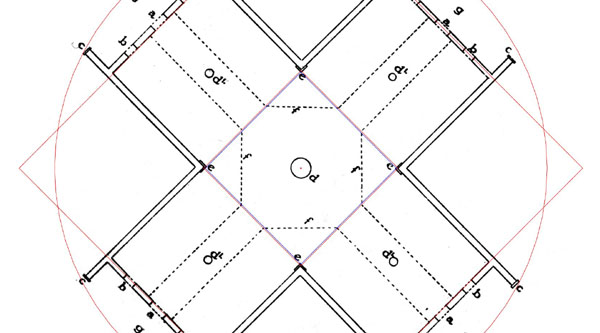
Let's look at the attributes of the central calculation matrix:
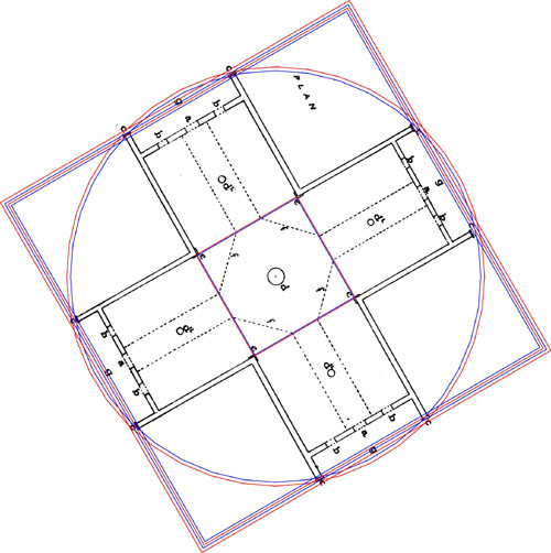
The square calculation matrix extending to the walkway edges
had a diameter of 14 feet. This culminated in a perimeter value of 56 feet or
672 inches. The 56 feet perimeter would have been used for solar calendar or
lunar calculations, using the same systems as found at Stonehenge where the
56 posts of the Aubrey Circle were suitable for the selfsame purposes. This
square could also have been interpreted as 54 positions and been used under
that calibration for whole day counts of the 6804-day lunar cycle.
Sitting snugly within the 14 feet diameter square is a circle with a circumference
of 44 feet (44 ÷ 3.1416 = 14.00560224 feet (14 feet). This is in similitude
to the 44 feet diameter altar atop the Great Pyramid and the circumference of
this circle contains geodetic/ navigational information. The circle itself is
1/2970000th of the size of the Earth under the "11 series" (furlong)
geodetic system. The value of 44 feet is 528 inches and the "mile",
derived from 528, is 5280 feet. David Wood found clear expressions of a precisely
marked mile at Rennes le Chateau during the Southern France investigations In
keeping with the codes incorporated into the altar of the Great Pyramid, it's
very likely that a circle of 42 feet circumference lay inward of the 44 feet
circle. This number relates to many ancient applications.
If the 42 feet circumference circle is expanded by PHI it touches the external
corners of the 4 large corner moldings to an excess tolerance of .188th of an
inch (about 4.8mm). The actual coded diameter of a square fitting diagonally
into this region would be 21.6 feet and it would sit snugly within the 4 external
corner points of the moldings. This square relates to the Precession of the
Equinoxes duration of 25920-years, wherein the time it takes the Sun to move
between houses of the zodiac is 2160 years. It also relates to the diameter
of the moon (2160 miles). The sum total of this square's perimeter is 86.4 feet.
The diameter of the Sun is 864000 miles. The inch value of this square's perimeter
is 1036.8 inches. This is 518.4 X 2 and the face angle of the Great Pyramid
was 51.84-degrees. The azimuth angle of the Octagon earthworks observatory complex
of Newark, Ohio is 51.84-degrees and 51.84 years is 1/500th of 25920 years…the
duration of the Precession of the Equinoxes.
The perimeter value of this square @ 86.4 feet would be 1/70th of 1 minute of
arc under the sexagesimal geodetic system. The square could, therefore, be calibrated
for geodetic calculations, as it is 1512000th of the "ring" of the
Earth (the Great Pyramid's perimeter value was 3024 feet (½ a minute
of arc) under its sexagesimal assignment (1512 X 2).
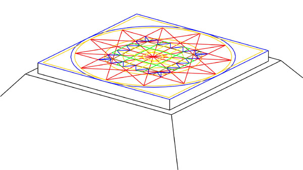
Two pictures of the central calculation matrix of the Octagon at Newark Ohio, showing the central mounds being used to encrypt an expanded variety of closely similar "square" codes, in much the same way as the secondary posts did at Miringa Te Kakara's Crosshouse.
Like at the Octagon, a parcel of specific codes much used in antiquity and
with a pedigree extending back to Egypt, was undoubtedly used within the central
zone of the Crosshouse. These expanded/ diminished codes would have been originally
marked either at the extremities of the secondary posts, inner positions of
the posts or graduated onto the wide, wrap around corner moldings. Here is a
list of the potential secondary post-codes and their specific functions within
the universal astronomical/ navigational system.
Running from wrap around molding to wrap around molding were 2 squares of
marginally different dimensions. The first of these has been discussed already
with sides of 15.708 feet (indicating the numbers associated with ½ PI…PI
being 3.1416). This square runs to the wall line behind the thick wrap around
moldings. The second, slightly smaller square was intended to convey 15.625
feet per side, which is a ½ value of 31.25. The very important ratio
1: 3.125 was used to differentiate between the length of a mile and the length
of a league (3.125 miles). It's very probable that the same region also coded
15.75 feet, which is the ½ value of 31.5. The Greek Stadia measurement,
also used on the Great Pyramid and originally an Egyptian increment, was 630
feet or 315 feet X 2. Both 3.125 and more especially 3.15 were sometimes used
as slightly rounded forms of PI (3.1416) to produce convenient whole numbers
that could be broken down by mathematical progressions. Thus the 7920 mile diameter
of the Earth (accurate) was considered to be 7920 leagues in circumference under
the "11" series geodetic system, with 3.125 miles per league.
The 15.708 feet internal width of the Crosshouse is duplicated, at increased
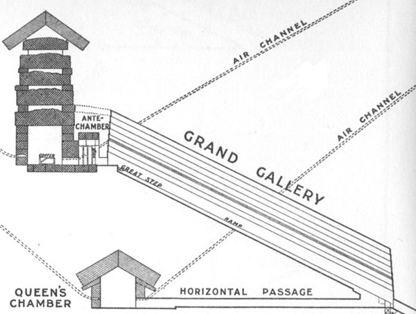
ratio, in the length of the Grand Gallery within the Great Pyramid. Sir William
Flinders Petrie measured it as 157 feet and one assumes an expression of ½
PI numbers at 157.08 feet. Similarly, such expressions of coded PI are found
at Stonehenge (related to a stone marker position)… and at the Octagon
complex of Newark, Ohio (related to a distance to the nose of an embankment).
The circle shown has a radius value of 157.08 feet from the Stonehenge centre
and falls upon a marker stone at the SE of the site. The same southeastern circuit
marks the base of the rising embankment beyond the Aubrey Circle. This outward
distance, marked by a former standing stone, was the same as that within the
Grand Gallery of the Great Pyramid.
Whereas it has been shown that the full internal width of each wing within the
Crosshouse was meant to code ½ PI, another square exists which codes
15.625 feet. This square runs between the 4 noses of the wrap around molding
and was used within the Crosshouse to achieve a special square footage code
applicable to the Khafre Pyramid and to the Moon. This is how the square footage
code is extracted:
The internal length of the Crosshouse can be interpreted under 3 geodetic
increments as 45.3049492 feet (PHI coding), 45.36 feet (sexagesimal coding)
or 45.75 feet ("11" series coding). These increments range before
and through the door threshold. Of these measures the one in most common usage
was the sexagesimal Royal Cubit, achieving a length interpreted as 45.36 feet.
If this is multiplied with the central width value of 15.625 the result is 45.36
feet X 15.625 feet = 708.75 square feet. This is the length (708.75 feet) of
the Khafre Pyramid (Egypt's pyramid of the Moon), which is 15/16ths of the length
of the Great Pyramid (756 feet)…so why did the builders of the Crosshouse
wish to incorporate the number 708.75?
The ½ value of 708.75 is 354.375 and this value in days represents the
duration of the lunar year, which is 11 days shorter than the solar year. One
twelth part of this value is 29.53125-days, which is the duration of the lunar
synodic month to an accuracy of 57 seconds excess. There would be 230.4 such
months in the 6804-days describing the lunar nutation cycle…or 115.2 X
2 such periods. Remember the 11.52 code is found as degree angles (azimuths)
in the Crosshouse. It is also found in the square inch values of each doorway
(4 feet high by 2 feet wide…1152 square inches). It is found in the height
of the main ridge rafters (11.52 feet). The square footage values for each side
of the Great Pyramid (with the flat floor configuration) was 230400… or
8 Egyptian acres of 28800 square feet each.
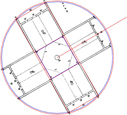
STONEHENGE'S STATION STONES CODE AND ITS RELATIONSHIP TO THE CROSSHOUSE.

There are 4 station stones at Stonehenge, which represent surveying fixes
for the site to the summer solstice, first glint rise position at an azimuth
at 48.6-degrees. The rectangle made from the station stones is 264 feet long
and 113.4 feet wide. The 264 feet figure is for mnemonic reference to 528 or
5280, which relates to the "mile" increment and two sides of the station
stones rectangle achieve a combined value of 528 feet.
The width of the station stones rectangle is based upon a lunar code progression
and is 113.4 feet. This value is 1/60th of 6804-days…the nominated period
representing the 18.613-year lunar nutation cycle. At 90-degrees opposed to
this rectangle's eastern length was the sunrise position at 48.6-degrees.
At the Crosshouse a similar coding exists, wherein a 52.8 feet (26.4 X 2) length
code, tucking lengthwise in behind the end plates of two wings, is accompanied
by a lunar code, describing the outer width of the wings. The lunar code chosen
is in the same family as the Stonehenge code and is 17.01 feet. This designates
the width of the Crosshouse wings to their external wall positions. The "station"
code rectangle for the Crosshouse at Miringa Te Kakara is therefore 52.8 feet
in length X 17.01 feet wide. The sum of 1701-days would represent 1/4th of the
lunar nutation cycle of 6804-days. The value of 1701 feet is clearly coded into
the Octagon at Newark, Ohio. At the Crosshouse each of the 4 wings complies
with this external width and the sum total of 4 X 17.01 = 68.04…in mnemonic
reference to the 6804-day cycle of the moon.
At 90-degrees opposed to this Crosshouse rectangle is the sunrise position for
first glint (60-degrees azimuth) and this design feature exactly parallels the
"station stones" design layout at Stonehenge.
The same surveying principles inherent in the "Station stones"
codes of Stonehenge, found at the Crosshouse, including a 90-degrees opposed
sunrise position. It must be noted that there was some deliberate variation
in the depth of the porches to achieve additional coding and this code will
only work through 2 wings, although it is mnemonically inferred through the
90-degrees opposed wings as well. It also seems significant that it is onto
the same solstice sunrise, in the same day period as when the observation takes
place at Stonehenge (Summer solstice for Stonehenge and Winter solstice for
the Crosshouse). It will be remembered that the internal length of the Crosshouse
was 26.4 E.R.C. (½ of 52.8).
The outside width of each Crosshouse wing was coded to the lunar value of 17.01
feet, in mnemonic reference to the 1701-days that constituted ¼th of
the lunar nutation cycle of 6804-days. This dimension is further corroborated
by expanding it by double PHI (3.2360678), which creates a circle or square
of, essentially, 55 feet, to a tolerance of about ½ an inch increase
(55.04551328 feet).
THE CIRCUMFERENCE OF THE EARTH AND THE REED CODE
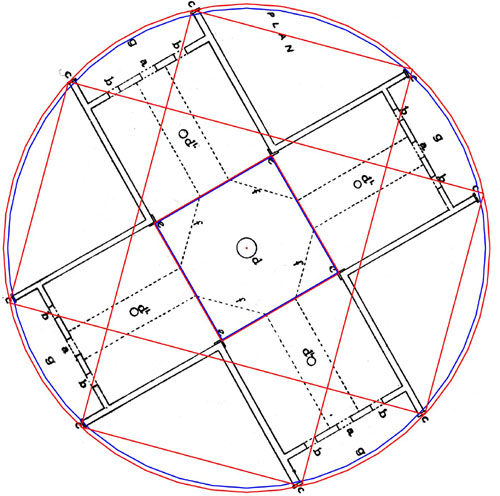
The overlaying rectangles sit within the 56 feet diameter circle to a tolerance
of about .15 of an inch (3.8mm) and are sized 26.25 feet X 49.48363636 feet
(28.8 Egyptian Royal Cubits of 20.61818182 inches each). The ½ value
of 49.48363636 feet is 24.74181818 feet and the sexagesimal geodetic circumference
of the Earth was 24741.81818 miles. This ½ length is therefore indicating
the circumference of the Earth. There are 4 lengths @ 28.8 ERC, accumulating
into a total of 115.2.
This length would have also represented 49.5 feet or 24.750 feet for the ½
length. The circumference of the Earth was 24750 miles under the "11"
series system (league/ furlong). The value of 24.75 feet is ¼th of 99
feet and, as we will see, this "11" series geodetic system was encrypted
outside of the Crosshouse.
The rectangle widths are 26.25 feet and this increment is related to the "reed"
measurement of 10.5 feet (126 inches). Because there are 4 sides represented
as 26.25 feet each, their combined total is 105 feet or 10 reeds. The 56 feet
circle delineates the limits of this coded length and it is inferred literally
in two wings and symbolically in the 90-degrees opposed wings.
It's interesting to note that the 26.25 feet (2.5 reeds) was a major increment
used on the inner Sarsen Circle lintels at Stonehenge, wherein every 30-degrees
of arc (the length of 1 house of the zodiac) was 26.25 feet or 2.5 reeds (2.5
lintels). The same increment was used as a founding measurement at "Serpent
Mound" in Adams County, Ohio, as well as on the Octagon at Newark, Ohio.
PI, 1728 AND THE EXACT EQUATORIAL CIRUMFERENCE OF THE EARTH.
We have already seen how the internal corners adjacent to the doorways of
the Crosshouse comply very closely with a progression of numbers related to
PI (31.416 ÷ 8). The progression moves in increments of 3.927 feet and
11 such progressions achieve 43.197 feet. This seems to be how the ancient priests
of the Crosshouse would have used the corners as PI code bearing repositories.
The blue line shown lies at an azimuth angle of
43.197-degrees.
Alternatively, the priests would, most certainly, have "rounded upwards" the 43.197 feet to mean 43.2, as this is one of the great numbers of antiquity and features in many calculations. The sum of 43.2 feet is 518.4 inches, again alluding to the 51.84-degree angle of the Great Pyramid and Octagon complex or to the use of 51840 feet in navigation. Again this coding will work literally through two wings and is inferred mnemonically in the 90-degrees opposed positions The Great Pyramid is 432 Celtic Royal Cubits of 21 inches each, per side or 1728 for the full perimeter. The 55 feet diameter circle, encompassing 2 wings of the Crosshouse, has a ¼ value of 43.197 (432 "rounded") feet or a "rounded" circumference of 172.8 feet. This relationship between a circle based upon a 55 or 550 diameter became the primary ingredient in most ancient navigation and was at the root of success in grid referencing the world for circumnavigation. The 4 lengths of these rectangles therefore infer the number 172.8. Silbury Hill in England was built to a diameter of 550 feet.
Whereas the lengths aspect of these rectangles relate to 43.197 (PI progression)
& 432, the widths relate to determining the exact equatorial circumference
of the Earth. As has been mentioned, the 1728 number is of extreme importance
to worldwide navigation and there was one type of Egyptian Royal Cubit that
was marginally longer than the 20.618 inch rod. Inference to it is found in
the dimensions of a stretch of paving slabs at the base of the Great Pyramid,
where the measurement infers 20 X 1.728 feet, culminating in a measurement of
34.56 feet. Note: the outer rim of the Sarsen Circle complies with 345.6 feet
from a PHI achieved diameter of 110 feet.
Such a rod (20.736 inches), subjected to the formula for determining the circumference
of the Earth in miles (multiply the rod length in inches X 1200 and read the
resultant number in miles), gives a reading of 24883.2 miles. In consideration
of the fact that our modern reading is 24902 miles for the equatorial reading,
this figure is a shortfall of only 18.8 miles.
The evidence at the Crosshouse suggests a 20.736 feet reading was intended in
the widths achieved between the internal corners, wing to wing or 1.728 feet
X 12. The inch reading of any of the 4 widths provided the numbers for remembering
the accurate equatorial reading of the Earth's size…248.832 inches per
side, translating into 24883.2 miles.
Although this system of Earth size calibration was reasonably reducible into
degrees and minutes of arc, it was nowhere near as fluid or convenient as the
"11" series geodetic system or the sexagesimal/ septimal system, which
dovetailed into each other mathematically. They provided the best means for
easy intercontinental positional plotting and degree angle determinations, while
accepting that the "11" series system was 1: .994647 correct and the
sexagesimal system was 1: .99431818 correct.
MULTIPLE LAYERING OF CODES, AN ANCIENT PREOCCUPATION.
Ancient "Masters of the Craft"and priests in Northern Hemisphere
"Schools of Learning" or Tohungas within the New Zealand Wharewaenangas
were in possession of vast ancient knowledge that had to be handed down to ensuing
generations in its purity.
In the Lore of the Wharewananga, page 84 it says, 'It was in
these temples, colleges or houses of learning that the priests of old taught
the young men of their particular tribes, with the constant admonition never
to depart from what they learned, nor to allow other subjects than those taught
by the tribal priests to be introduced into the Colleges. The Sage states that
youths from other tribes might be taught therein; in which probability he means
the series of tribes of the East Coast who all, more or less, are related to
the descendants of the crew of the "Takitimu" canoe that came here
about 1350, and also to the original tangata-whenua people, about whom we shall
learn later'.
As is the case in the encryption of coded information across the entire world,
there was a large parcel of information to preserve and code bearing repositories
like the Crosshouse had to be designed in such a way as to clearly demonstrate
as much as possible. For this reason, deliberate variations are seen to exist
in the extremity measures (end plates) from wing to wing, especially in the
widths of the outer porches. It is, therefore, difficult to assign one "all
encompassing" square that clearly envelops each wing.
Surveyor P.G. Hunt describes the overall length of the Crosshouse as achieving
54 feet. The drawn evidence from his 1958 plan might suggest that one wing achieved
27 feet (½ of 54 feet) from the centre post to the outer face of the
vertical, large, thick and "shaped top" end boards. The general measures
per wing length appear however to range down to around 26 feet from the epicentre
of the centre post. Let's explore the possibilities:
It would appear that a 54 feet square would be about 2 inches too big to perfectly
enshroud the Crosshouse. It is however a very important code, as are both 55
and 56 and was probably included in a mnemonic sense. The inch total of 4 sides
@ 54 feet per side would be 2592 inches and 25920-years was the anciently used
number to describe the Precession of the Equinoxes. Evidence upon the Calendar
of Coligny of France would suggest that the first Sabbatical period in
the 7 X 7 years of the Sabbatical Calendar was calibrated to endure for 2592-days.
Other candidates for outer rim coding include 53.130 feet, which codes an angle
found in 3,4,5 triangulation (53.130-degrees) alongside an angle of 36.87-degrees.
The 36.87-degree angle was coded into the wall slats in the porches.
The reed code of 52.5 could have been coded, as well as 52 (calendar) or 51.84
(navigation and Precession).
THE OUTER STANDING POSTS.
It would seem that only a few of the large outer posts, included in the
surveying markers to which the Crosshouse was originally fixed, have survived
until the present day. In some instances there are only depressions or ground
level rotting residues where the impressive posts once stood. During a survey
of 1/7/2001 the positions of the remnant outlying posts were measured in relation
to the centre post of the Crosshouse. It appears obvious that there were once
more of these post marked positions and some careful surveying work should help
in relocating the now vacant former positions.
The present distribution of surviving posts seems to indicate the following
codes:
SUMMARY
Oral traditions handed down through Maoridom or observations by early colonial
maritime explorers and historians have been relegated to the category of "unreliable"
by today's historians. More and more, these accounts, which run counter to mainstream
thinking, are pushed further into the background.
Whereas "historical interpretation" can be considered as something
of an "inexact science", that set of circumstances need not apply
to all categories of historical/ archaeological research. With the finding of
ancient standing stone circles and mathematical code bearing structures in New
Zealand, the field of investigation broadens to include the surveyor, architect
and mathematician. Because surveying is one of the exact sciences, we now have
the capacity to detect the scope of ancient New Zealand knowledge related to
mathematical categories of science. From the residual structures scattered across
our landscape, many of which clearly relate to astronomy, we can detect both
the measurement standard used and the level of astronomical knowledge attained.
By comparative analysis, we are able to see the migration of a parcel of astronomical/
navigational numbers, moving from continent to continent and their encryption
into ancient regional structures. We are able to see the repetition of a "standardized"
astronomical/ navigational methodology appearing in many climes and latitudes,
all traceable back to, at least as far as, the Giza Plateau.
If we are truly zealous about knowing the long-term history of New Zealand,
then it is time to fully open up stagnated fields of research…by locating
the many standing stones or stone circle arrangements, for assessment by surveyors.
We must also investigate ancient human remains in remote burial caves and subject
them to the latest techniques of DNA fingerprinting and comparative physical
anthropological analysis.
Far from knowing our long-term regional history…we have hardly scratched
the surface.
Martin Doutré (Druidic Inferior Rhymer).
December 30, 2001, Auckland, New Zealand. ©