The ancient Mediterranean trade route links to Nazca, Peru:
In 1991 a fleet of 14 large wooden ships were found buried at Abydos, Egypt, eight miles from the Nile River. The ships ranged from 60 to 80-feet long and are known to be at least 5000-years old. The Abydos fleet was analysed, in part, by Cheryl Haldane, nautical archaeologist from Texas A & M University, who stated that "they showed a high degree of technology combined with grace". Hancock wrote: "they were of an advanced design, capable of riding out the most powerful waves and the worst weather of the open seas." (See Fingerprints of the Gods, chpt. 45, pp 431 & 432).
Pottery from Egypt, which can be dated to 3500 BC, depicts ships with sails and wall paintings in the Nile Valley, dating to 4500 BC show high prow, long sleek ships. One well preserved, heavy planked ship, attributed to the Pharaoh Cheops (circa 2600 BC) is 150-feet in length.
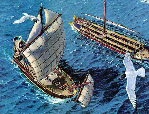
We know that the Phoenician Round Ships were trading throughout the Mediterranean and into the Atlantic from at least 1300 BC and the Phoenicians maintained tin & lead mines in Britain or silver mines in Spain. Their ships were large, sturdy, ocean going vessels.
When Julius Caesar made his maritime invasion of Gaul (France) in September 55 BC, he wrote that, "...about 220 of their ships, fully equipped and appointed with every kind of [naval] implement, sailed forth from the harbour, and drew up opposite to ours; nor did it appear clear to Brutus, who commanded the fleet, or to the tribunes of the soldiers and the centurions, to whom the several ships were assigned, what to do, or what system of tactics to adopt; for they knew that damage could not be done by their beaks; and that, although turrets were built [on their decks], yet the height of the stems of the barbarian ships exceeded these; so that weapons could not be cast up from [our] lower position with sufficient effect, and those cast by the Gauls fell the more forcibly upon us." Caesar described the Gallic Swan ships of the Veneti (the Celtic Gauls-Britons, controlling the English channel and coastline of both France and Britain) as deep water vessels, capable of intercontinental voyages ..."vasto atque aperto mari" ... "upon the vast open sea" [where the Veneti were used to navigating]. See: De Bello Gallico, by Julius Caesar.
One of about 220 Gallic-Briton Swan ships and other war vessels that came to do battle with the Roman biremes and triremes in 55 BC. If the wind on the day had not of died to nothing, within the narrow confines of the Loire Estuary, the huge, sturdily-built Gallic ships would have won the battle.
So, the question one could ask is, where were the Veneti of Gaul and Britons learning the arts of navigation for safe traversals of the oceans? Caesar himself answered the question, in part, when speaking about the Druidic teachers and their huge schools:
'They hold aloof from war and do not pay war taxes; they are excused from military service and exempt from all liabilities. Tempted by these great advantages, many young men assemble of their own motion to receive their training, many are sent by parents and relatives. Report says that in the schools of the Druids they learn by heart a great number of verses, and therefore some persons remain twenty years under training'.
'They do not think it proper to commit these utterances to writing, although in all other matters and in their public and private accounts they make use of Greek characters. I believe that they have adopted the practice for two reasons- that they do not wish the rule to become common property, nor those who learn the rule to rely on writing and so neglect the cultivation of memory; and, in fact, it does usually happen that the assistance of writing tends to relax the diligence of the student and the action of memory...They also lecture on the stars in their motion, the magnitude of the Earth and its divisions, on natural history, on the power and government of God; and instruct the youth in these subjects' (see De Bello Gallico, VII, 15, 16.).
Isabel Hill Elder further writes, 'The students at these colleges numbered at times sixty thousand of the youth and young nobility of Britain and Gaul. Caesar comments on the fact that the Gauls sent their youth to Britain to be educated... It required twenty years to master the complete circle of Druidic knowledge. Natural philosophy, astronomy, mathematics, geometry, medicine, jurisprudence, poetry and oratory were all proposed and taught-natural philosophy and astronomy with severe exactitude.' As her sources, Elder refers to: Strabo I IV, page 197. Caesars Comm. Lib V. Sueotonius, V Calegula. E. Campion, Accounts of Ireland, pg. 18.).
Regarding the well-spring of Druidic knowledge, Isabelle Hill Elder writes:
'The education system adopted by the Druids is traced to about 1800 BC when Hu Gardarn Hysicion (Isaacson), or Hu the Mighty, led the first colony of Cymri into Britain from Defrobane, where Constantinople now stands'. Further commenting on Hu Gardarn Hysicion, Isabel Hill Elder writes that he, 'is commemorated in Welsh archaeology as having made poetry the vehicle of memory'. Elsewhere she writes, he 'is said to have mnemonically systematized the wisdom of the ancients...'. She goes on to say, 'The published compositions of the Druids and Bards form but a very small portion of the extant remains of their works. The Myvyrian MSS. alone, now in the British Museum, amount to 47 volumes of poetry, in 1600 pages, besides about 2000 epigrammatic stanzas. Also in the same collection are 53 volumes of prose, in about 15,300 pages, containing many curious documents on various subjects...' (see Celt, Druid and Culdee, pages 54 & 55).
Huge open air universities, like Avebury Henge and its many outer marker mounds, standing stone circles, etc., in the surrounding landscape, were where the thousands of students went to learn these scientific arts.
By the time of De Bello Gallico (The battle of Gaul) there were already well-established maritime traditions, coupled with advanced expertise in shipwright skills and navigational techniques, spanning several thousands of years of accrued experience.
Early Irish traditions, as well as those of other groups throughout the British Isles, speak of former residence for their people in Egypt and its Mediterranean satellite countries, from whence bagpipes, harps, language roots, cultural symbolism and even the venerable oak-tree or the Stone of Scone (upon which generations of Irish, Scottish and English monarchs received their coronations) have their origins. In support of these longterm oral and written traditions, leading physical anthropologist, Professor C. S. Coon of Harvard University, wrote in 1939:
"A true and valid similarity, however, may be found between the English Long Barrow series and early skulls from al'Urbaid in Sumeria, which, whether belonging to the fourth or third millennium B.C., are in either case older than their British counterparts. The only difference which prevents identity is that the Mesopotamian faces and noses are somewhat longer" (p. 112 of Races of Europe, Macmillian, New York, 1939).
On page 83 he wrote: "It can be shown that Sumerians who lived over 5000 years ago in Mesopotamia are almost identical in skull and face form with living Englishmen and that pre-dynastic Egyptian skulls can be matched both in a seventeenth century London plague pit and in Neolithic cist graves in Switzerland."
The "waymark trails" of this ancient exodus from Egypt and Israel, marked by standing stones, cairns, dolmens, mounds and stone circles, extends along the top of North Africa to the Pillars of Hercules, where the ancient migrants crossed the narrow Mediterranean straits to Gibraltar. The waymark trails further extend along the Atlantic coast to France and Scandinavia in the north and towards the British Isles to the west. Other trails, marked in similar fashion, extend to China and Korea (See: Palestine, by Major C. R. Condor, R. E. Phillip & Son, 1889 pp. 142-157; See also: Across The Jordan, by Gottlieb Schumacher, Richard Bently & Son, 1886).
AN ANCIENT OUTPOST & CIVILSATION OF THE EUROPEAN-MEDITERANEAN COUSIN NATIONS.
It is a well attested fact that the sea does not abide fools well, nor compensate for any lack of knowledge. Anyone who ventures out upon the vast, featureless and often violent ocean does so at their peril and needs to be both very well equipt and an adept navigator. The fact that ancient Egyptians or Peruvians were sailing back and forth between the Mediterranean, Peru and Bolivia is very well attested, scientifically proven and beyond dispute, due to the excellent discoveries by German scientist Svetla Balabanova (1992) and two of her colleagues (See: Balababova, S., F. Parsche, and W. Pirsig. 1992. First identification of drugs in Egyptian mummies. Naturwissenschaften 79:358).
Balababova positively detected cocaine (Erythroxylon coca) and nicotine (Nicotiana tabacum), which are solely South American alkaloid-substance bearing plants from Peru & Bolivia. The cocaine was ingested by ancient Egyptians as a sedative, probably by people suffering the pain of toothaches or to quell discomfort associated with injuries and debilitating illnesses in old age. The nicotine derived from South American tobacco was used as a body wash in the mummification process or for soaking wrapping bandages to kill the bacteria that causes putrification of tissue. In this usage the nicotine acted as a strong preservative.
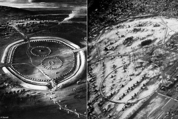
Left: The Great sprawling school
of Avebury Henge in Southern England, which provided tutorials in navigation
and astronomy, not only internally, but from stations and structures in the
surrounding landscape that related back to a giant obelisk within the henge.
The same lengths and angles that one finds on the Gizeh Plateau of Egypt are
represented in the tutorials of Avebury Henge. The circumnavigating embankment
acted as a false horizon, similar to the horizon on the open sea and students
could familiarise themselves, over a long period of training, with solar, lunar,
planetary and stellar rises and sets or cycles.
Right: The Octagon earth embankment
complex of Newark, Ohio, which also acted as a "henge" offering a
false horizon for tutorials in celestial navigation. If the Great Pyramid of
Egypt were placed upon the foreground circle embankment of the Octagon. the
circle would perfectly encompass each corner of the pyramid and skim or brush
them. The internal length of the Octagon, from an altar platform on the foreground
circle, through the Avenue and to the extremities of the end gate, would be
2835-feet or equivalent to one circumnavigation of the Khafre Pyramid of Egypt.
The sum of 2835-days would be 8 lunar years and there is copious lunar coding
or emphasis in the dimensions, angles and purpose-built observation stations
of the Octagon. All design lengths and angles found within the Octagon have
counterparts in the observatories of Britain and Continental Europe, extending
back to the coded design features of the Gizeh Plateau, its causeways, walls,
pillar counts and edifices.