THE NEWPORT TOWER
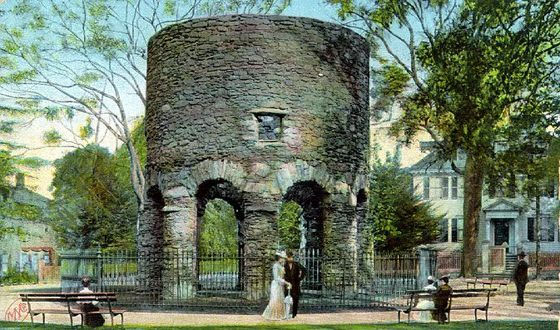
Residents of Newport, Rhode Island, are depicted relaxing in their Sunday best in this 1900 postcard image of the mysterious stone tower at Touro Park. The old tower is located on top of a hill at Aquidneck Island, overlooking Narragansett Bay. Controversy has raged over several centuries as to whether or not this structure was built during the US colonial era or much earlier, prior to the voyages of explorer, Christopher Columbus.
Although there's plenty of conjecture both ways, no definitive historical documentation exists to prove that the structure is either colonial American or pre-Columbian.
Those who argue for a colonial timeframe of building claim, amongst other things, that it was first conceived of as a windmill. It is also variously represented as a church, a lookout and defensive tower or as an astronomical observatory with sophisticated, in-built solar and lunar time-fix attributes.
The astronomical features of the structure are well-proven and observable on a bi-annual basis, extending out to very impressive and precise fixes onto the 18.613-year lunar nutation cycle.
The question then arises: Why would a simple windmill or a tower built for defence incorporate such advanced astronomical science into its dimensions, orientation and the odd, irregular placement of window slots to receive the Sun on Solstice days?
One theorist claims that the building was, essentially, the very first colonial structure of any true consequence for North America, dating to 1582-83 and built by astronomer-mathematician, John Dee, who was a philosopher in the court of Elizabeth I of England.
The question goes begging, however, why would newly arrived colonists, who were lacking in the most basic necessities of life, undertake to build a structure of such design sophistication, incorporating pillared arches, keystones, specially shaped and placed symbolic stones, astronomically oriented windows, etc.
Yes, a simple, hurriedly erected mill for grinding grain would have made perfect sense for the pioneers, or a defence-watchtower for detecting and warding-off hostile indians, but not something that required such meticulous design planning, surveying precision and careful checking through each difficult stage of erection.
To build such an astronomical-observatory edifice, one would have to undertake years of observation of the local landscape before choosing the exact spot where the structure would ultimately have to stand. One would need to gain expert knowledge of how to exploit surrounding terrain and geological features for providing precise time fixes for the Sun & Moon at that latitude and with that selection of surrounding elevations to choose from.
Before the plans for the building could even be drawn up, the builder of the Newport observatory tower would first have to search around the horizon for conspicuous and exploitable outer-marker features that coincided with the Sun rise and set positions at the solstices and equinoxes. Having the sun rise or set on the high point of a distant hill or island (outer-markers) from the observatory-tower position, would be the purpose of the exercise.
The degree angle to a point on the horizon where celestial bodies are seen to rise or set on significant days (solstices, equinoxes, etc.) change according to the elevation of the horizon outer-markers (mountains, pinnacles, bowl-dips, etc.). High ground at the inland horizon can offset the angled rise or set position of the sun or moon by several degrees and up to an hour in time, over and above witnessing the same event on the sea horizon.
UNSURPRISING.
It would be no great surprise to find out that the Newport Tower was erected centuries before North American colonisation, as upwards of 30,000 incised stones and boulders, etc., bearing European and Mediterranean scripts (many perfectly readable), have been found in North and South America to date. Added to that are thousands of huge and laboriously built geometric earth embankments, ancient mound groupings and all manner of other structures including forts, vast stretches of roads and thousands of rock walls, as well as the skeletal and artefact/ cultural symbolism or linguistic evidence of Continental European and Mediterranean peoples ... spanning thousands of years of occupation.
However, if the Newport Tower is pre-Columbian, then, conceivably, it should do considerably more, in a code-bearing sense, than just the several astronomical attributes already detected and documented within it. In the more remote epoch it would have acted as a mnemonic structure for preserving and teaching the ancient mathematical principles used for navigation around the world, as well as the numbers used for describing durations of time in cyclic astronomy.
All of the design features of the building would be code-bearing by way of length, breadth, height and in terms of detectable, built-in angles.
So let's see if the Newport Tower stacks up to expectations in that regard:
Firstly, if it was built as an observatory or surveying landmark, its position on the landscape would have to be tied to a primary or secondary point of the compass to give a true, very identifiable and repeatable reading. By reference to one or more precisely known outer-marker benchmarks, ancient alidade sighting rules or later theodolites, set up at the tower, could take accurate degree angle-readings onto any targets visible around the horizon.
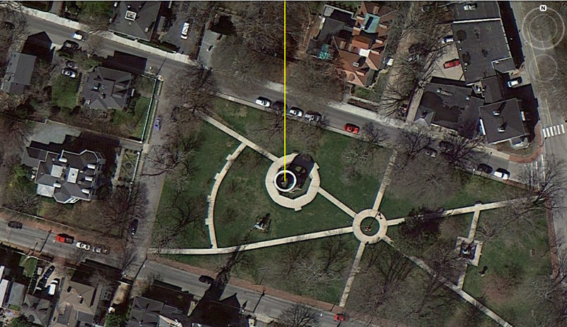
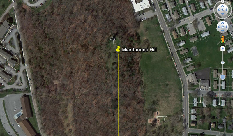
A picture of Touro Park on Aquidneck Island, Newport, Rhode Island, U.S.A., with the tower rim clearly visible and the tower's shadow extending out across the ground to the NNE. A yellow line is seen to commence at the epicentre of the tower. It runs due North (0 or 360-degrees) for a coded distance of 9072' and alights upon the summit position of Miantonomi Hill (155' above sea level).
Another very possible spot for a trig obelisk on Miantonomi Hill would have been at 8910' (1.5 ancient Scottish miles of 5940' each) from the centre of the Newport Tower.
It's highly likely that a stone pillar or obelisk, marking the exact point of Miantonomi Hill's summit, where the "due North" coded distance resolved to, would have been erected when the tower was first built and might still lie recumbent on the hill crown.
The line of sight from the centre of the Newport Tower resolves to the summit region of Miantonomi Hill and this high point, if precisely marked by a trig, would have provided very accurate orientation onto true North for surveyors-navigator-mathematicians doing overland fixes from atop the tower.
It seems obligatory that 9072' would have been one of the primary distance-codes chosen for usage in this instance, as it's a very ancient navigational value that related to the equatorial circumference of the Earth. This value was used by navigators for thousands of years and is found encoded into the base dimensions of the Great Pyramid of Egypt.
Here's why the number was so important:
The main design function for the base perimeter of the Great Pyramid was to record and encode the equatorial circumference of the Earth and provide ancient navigators with the essential mathematical knowledge they would need to grid reference the globe for successful positional-plotting at sea.
The sea is no respecter of persons and does not abide fools well. If one ventures out beyond the sight of land on the featureless oceans and doesn't know how to navigate, one will, undoubtedly, get lost and die a watery death.
The base length of the Great Pyramid is 756' (9072")*.
Note: The so-called British Standard "foot" and "inch" are very old and it was this self-same "inch" that was used in the fabrication of all the "cubits" of the Mediterranean, Continental European and British Isles' cousin nations during the past 7000-years and more. Latecomer civilisations like the Greeks and Romans simply adopted measurement standards formerly used in Egypt or Britain, etc., for thousands of years before the rise of these latter civilisations.
By this means, the so-called "Greek Mile" (5250') is far older than the Greeks. Likewise, the English Mile (5280') is found in Egypt also and who knows who had it first?
So, the Great Pyramid @ 756' per side = 3024' for 1 circumnavigation (4 X 756'). If one goes around the pyramid twice, one has covered 6048'. This distance is 1-minute of equatorial arc in the Earth's circumference. If one goes around the pyramid 3 times, one has covered 9072' or 1.5 minutes of equatorial arc.*
*Note: This statement about "equatorial arc" might sound complicated, but it's really quite simple. It goes like this:
60 seconds = 1-minute, 60 minutes = 1-degree, 360-degrees = the full circumference of the Earth.
So, if 6048' (2 perimeter circuits of the Great Pyramid) = 1-minute of equatorial arc (a 1/21600th segment part of the world at the equator), then 6048' X 60 (362880') = 1-degree of arc and 362880' X 360 = the entire distance around the world (130636800').
There was an easy way for ancient mariners and others to remember this, which was:
12 X 12 X 12 X 12 X 1.2 Greek miles (of 5250' ea.) = 24883.2 miles = 130636800'.
This was one of two major methods of mathematically configuring the Earth's equatorial circumference for successful navigation and positional plotting (dead reckoning) at sea. The method described above was the "6&7" method (combining the number families of 6 &7 together to get a Greek mile (5250'), which can be divided by either 6 or 7).
Under the 2nd method (using the "11" family of numbers), the Great Pyramid's base length is elongated a mere 3" to be 756.25'. Now a minute of arc is considered to be 6050', a degree of arc is 363000' and the entire equatorial circumference is 130680000' or 24750-miles of 5280' each (divisible by "11").
This second method of navigation and positional plotting was popular in Britain, as well as in Teutonic and Scandinavian regions 5000-years ago, through to more modern times. The 5280'-mile and its traditional subdivisions survive in the United States to this day.
So, the distance from the centre of the Newport Tower, due North to the marked crown of Miantonomi Hill would be 12 X 756' (twelve Great Pyramids of Egypt in a line) or 1.5-minutes of equatorial arc.
This distance would equate to 1/14400th of the equatorial circumference of the Earth.
This exact code was built into the "Unstan chambered cairn" in terms of its distance and angle from the "Ring o' Bookan", situated very near to Brodgar standing stone circle ring, Mainland, Orkney Islands, Scotland.
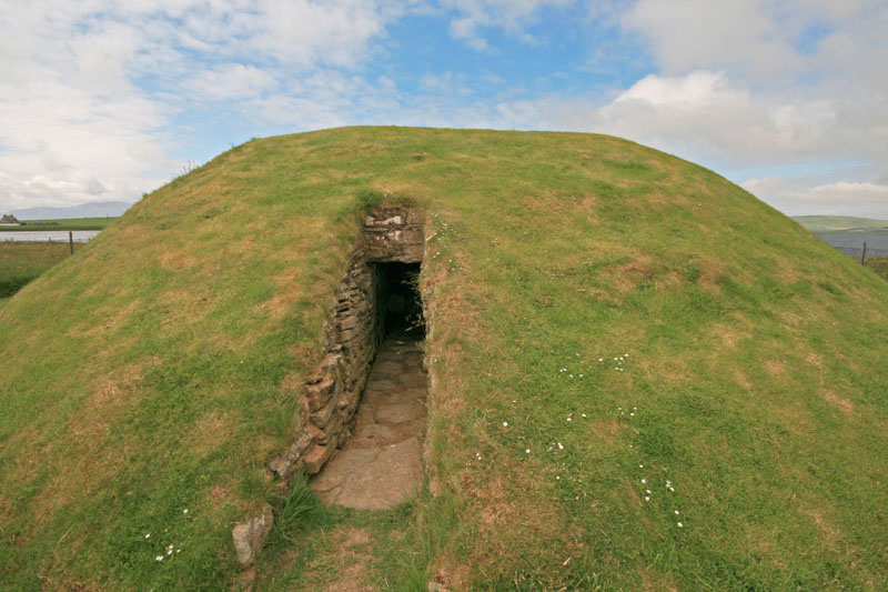
The distance from Unstan Chambered Cairn to the centre of the Ring o' Bookan is 9072' @ an azimuth angle of 360-degrees (due North).
North Americans will immediately detect the stark similarity between this structure and the many ancient souterrain structures that dot the Eastern Seaboard of North America. Much compelling evidence shows that Scapa Flow harbour, adjacent to Unstan Chambered Cairn and Brodgar Ring, was the main staging area for voyages, by many European and Mediterranean cousin nations, to North America during the Bronze Age.