In 2002 a resident of Hillsborough Auckland, Mr. Eric Lowe told me about entries in the diary his great grandfather who, during the late 1800’s, had worked as a New Zealand Government surveyor with such notables as Percy Smith. The grandfather had recorded words to the effect that, wherever he went to set up triangulation markers on the prominent hills, he could see the purpose-placed marker-stones of more ancient surveyors who had preceded him.
Similarly, in a very stimulating conversation with a learned Maori kaumatua-historian, he recounted an oral tradition passed down within his family that spoke of his ancestors arriving in New Zealand from India in 700 AD*. Upon making landfall, his ancestors encountered a well-established civilisation that they called "The Surveyors" ... because of their preoccupation with marking the landscape for overland surveying purposes. Although I was aware of many other names or terms used to describe the earlier civilisation (such as "The Stonebuilders") this was the first time I had heard of them being called, specifically, "The Surveyors" in the Maori oral histories.
*Footnote: Although our social-archaeologist and politically-aligned academics try to convince us that "there were no signs of human impacts upon the New Zealand landscape until about 1250-1300 AD", this "politically-correct" edict contradicts both the Maori oral traditions and the copious assortment of skeletal, artefact or landscape structural evidence, etc. In yet another criminal-cover-up of true New Zealand history and archaeology-anthropology, the remains of 53 very anomalous, ancient skeletons, held by Canterbury Museum (that have never been allowed to be properly studied or analysed by modern forensic methodology), will be "destroyed" on the 16th of April 2009. See: http://www.wairaubarmystery.co.nz
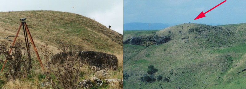
The careful and aware observer, especially those with a surveying background, can still detect the ancient trig marker stones, mounds and other types of surveying related structures or solar observatories that lie scattered over the length and breadth of New Zealand. Very often, modern trig towers sit beside the ancient purpose-placed stones or directly atop the ancient marker mounds built by New Zealand’s Patu-paiarehe people (the pre-Maori stonebuilders).
Some examples of this in and around Auckland City would be:
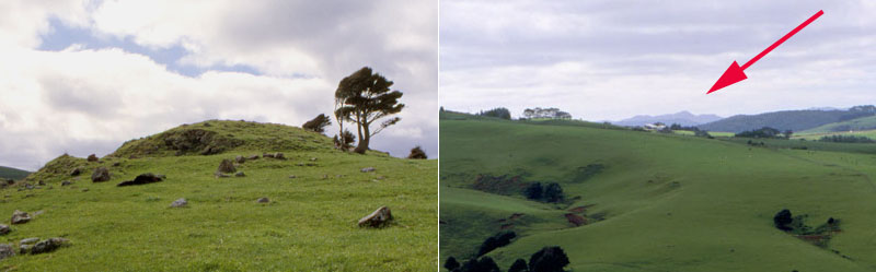
• Mt Albert’s high mound with the ancient marker stone still sitting adjacent to the modern trig tower. It marks the Equinox sunrise from the Mt. Wellington trench.
• Mt Wellington, where the trig tower sits atop the ancient Patu-paiarehe summit mound.
• AY57 geodetic marker on the high ancient mound at Pigeon Mountain.
• Stockade Hill, where British army engineers of the 1860’s had to move the ancient standing stones to build a redoubt. The position marks the Equinox sunset into the Mt. Wellington trench.
• Mangere Mountain’s A5YJ trig tower, which sits atop the ancient summit mound and its half buried marker stone.
• B2D4 trig tower at Mt William Walkway, which sits atop one of the largest purpose-built ancient mounds in New Zealand.
• A very impressive, symmetrical ancient mound at Duder's Park reserve, Kawakawa Bay, with a modern day trig tower now adorning it.
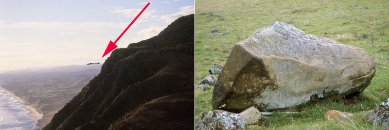
Similar examples are found all over New Zealand, such as at Maunganui Bluff in Northland, where the summit trig tower is encompassed by ancient cairn and standing stone markers circumnavigating the crown of the hill, each representing a resolving point for distant surveying targets around the horizon.
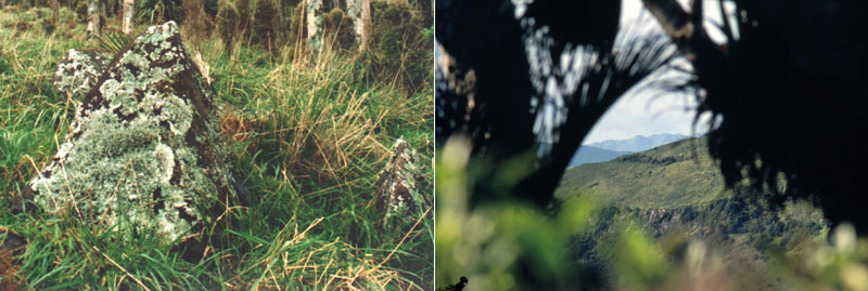
Throughout the colonial era of New Zealand, trampers, hunters, surveyors and others have encountered and been puzzled by the occurrence of stone arrangements on the high hills across the country, such as this set atop Moehau Mountain in the rugged Coromandel Range. Most of the ancient stone markers found across the length and breadth of New Zealand now lie on their sides, with many being half buried. It’s only the alert observer who can identify them as out-of-place, unnatural features and purpose-placed surveying trigs.
MANGERE MOUNTAIN
At Mangere Mountain one of the two trig towers sits upon an ancient mound that was built at the highest point of the extinct volcano. Situated around the cone crests and plateaus are multiple sighting pits or marker stones for fixed position views onto other Auckland Isthmus hills. Further NNE, Mount Wellington duplicates all of these same surveying features, including a modern-day trig tower sitting atop an ancient mound at the highest point. Mt Albert to the NNW does the same.
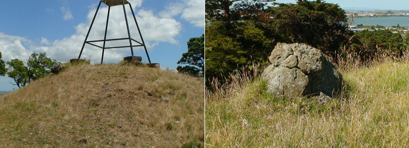
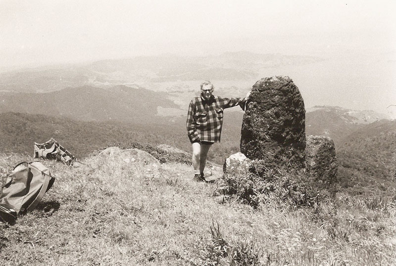
Left: A modern-day trig tower (A5YJ) sits upon the ancient mound and adjacent to it reposes the half buried, original marker stone placed upon the mound by the ancient surveyors.
Right: Sitting precisely 1/4th of a mile due South of the mound marker is another carefully placed boulder. Surveyors working from the high mound could set their ancient manual theodolites by reference to this due South marker-boulder and thereafter take very accurate degree-angle fixes onto any target within the isthmus or round the distant horizon. This occurrence of placing an outer marker at one of the primary points of the compass is very common to most observatory or surveying sites. A major standing stone observatory at Red Hill, Papakura, used a huge obelisk arrangement at Bombay, 7-miles distant as its due South marker.
From the marker boulder on the Southern side of Mangere Mountain’s cone, yet other surveying related attributes are vividly recognizable. The marker is situated there due to the view if affords out to the Manukau Heads, where the declining Northern and Southern sides form a distinct “V” in the landscape. All over New Zealand there was similar use of the distant terrain and dynamic geological features to establish fix points or benchmarks.
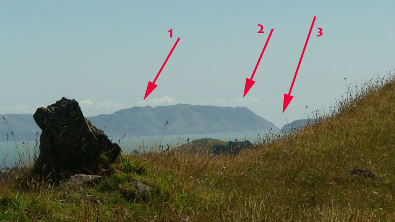
This highly magnified photo was taken from the Southern marker-boulder and shows the outlying standing stone from whence the Solstice sunset is seen to occur at the Southern Manukau Heads. The degree angle from the Southern-marker and across this outlying standing stone would closely approximate the Southern-most lunar-set position at the time of Lunar Major Standstill. This is the most extreme Southern position the Moon moves to in its 18.613-year cycle. The outlying standing stone appears to have the remnants of an ancient "bullaun" bowl carved into its base-rock and this still captures some water during rainfalls. Bullauns are found all over Ireland and are a very ancient cultural expression. They are also found to be laboriously carved into boulders all over New Zealand.
(1) The Solstice sunset alighting spot.
(2) A prominent “V” cleft situated at 243-degrees azimuth from the Southern marker boulder.
(3) The “V” formed by the declining sides of the Northern & Southern edges of Manukau Heads situated at 243.25-degrees azimuth.
Numerical progressions based upon this very important ancient lunar and navigational value 243 were built into the weights, measures and volumes of the ancient Mediterranean nations.
The precise North to South span between markers across the cone of Mangere Mountain undoubtedly served as a surveyor’s baseline for triangulation calculations of distances to outlying targets, especially those lying to the East & West. Using the sea horizon was also important for calculating elevations as will be demonstrated.
Left: Concretion boulders marked the observer’s standing position
for this solar observatory at Waiwera, which uses the “V” at Waiwera
Heads as the “first glint” solar rise point for the sun at the Equinox.
The trough of the “V” sits at 90-degrees azimuth (due East) and
is only marginally above sea level.
Right: From the same purpose placed concretion boulder markers the equinoctial
sun descends and lands perfectly in another prominent “V” in the
Western skyline. Concretion boulders, which grow like pearls over millions of
years, would have to have been laboriously transported from the sea estuary
far below this high yellow-clay hillside position, as they can only form in
sea sediments.
In the crest of Mt. Wellington the ancient Patu-paiarehe
surveyor astronomers cut a deep "V" trench. They also set up standing
stone observatory positions on Stockade Hill, 4.4-miles to the East of Mt. Wellington,
and on Mt. Albert, 7-miles to the West. From these two vantage points the ancient
astronomers could get very accurate Equinox fixes for solar rise and set.
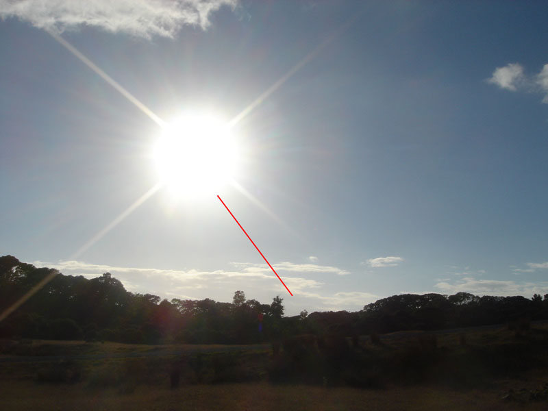
Left: From the observer's position atop Stockade Hill, Howick, the sun descends
on an angle and its base alights perfectly on the finite line of the cut trench
dissecting the crest of Mt. Wellington.
Right: From the observer's position by the marker stone atop Mt. Albert, the
sun rises at the trench position on Mt. Wellington and climbs on the diagonal
into the sky. This solar event recurs reliably at each Equinox, year after year,
and the annual calendar could be checked, regulated and kept precise accordingly.
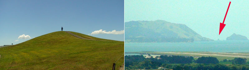
At Totara Park in Manurewa is a purpose-built, ancient Patu-paiarehe mound. It is one component structure in a very long surveying alignment that crosses the entire Auckland Isthmus from Mt William Walkway to Moirs Hill North of Puhoi. The high mound at Manurewa is in direct sight of Mangere Mountain, Mt Wellington and virtually all of the volcanic cones of Auckland. From the Totara Park mound a perfect dissecting alignment skims both the Northern and Southern edges of the Manukau Heads (seen highly magnified) at 260-degrees azimuth. The strategic position of the mound crest, on high ground, relative to the position of Manukau Heads would be the reason why ancient surveyors built the mound on that exact spot. The “V” trough benchmark at Manukau heads, used in conjunction with the sea horizon, represented a very important fix position from many secondary marked positions throughout the Auckland Isthmus and it’s very evident that trigonometric calculations were being undertaken using the Manukau Heads as a benchmark.
Astronomers working from Totara Park Mound, Manukau were
able to get very precise rise and set points from that vantage point.
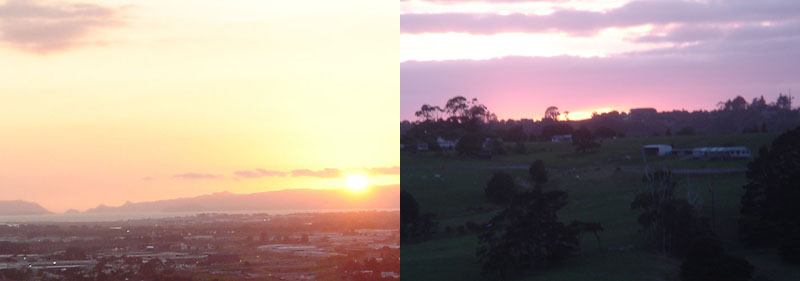
Left: The equinoctial sun descends and alights upon a very recognisable
geological feature of the Waitakere Ranges. The long range also provided very
recognisable fix points for the Summer Solstice to the South and Winter Solstice
to the North (Southern Hemisphere).
Right: The equinoctial sun rises in a very exploitable dip on a low hill range
to the East.
The Totara Park Mound enjoys the distinction of being very strategically or centrally positioned within the Auckland Isthmus and offering excellent views through 360-degrees of vista. It represented the perfect position for setting up a surveyor's baseline for accurate triangulation measurements, primarily towards targets situated within wide sweeps northwards or southwards.
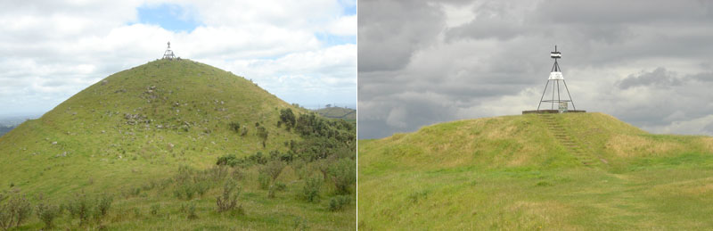
Two more of the ancient pre-Maori purpose built mounds of the Auckland Isthmus. Left: This is one of the biggest artificial mounds known about in New Zealand. It forms a part of a multi-component complex situated at Mt. William, Bombay, South Auckland and the immense size of this ancient structure made it highly visible as a surveying marker from Huntly and beyond. Right: Like the Mt. William mound, the ancient summit mound of Mt. Wellington has a modern-day trig tower atop it. This high point was a part of a straight-line set of structures stretching from Pukemore Hill in Huntly, to a small mound hump atop Mt. William, to Totara Park mound, to Mt. Wellington mound, to a cairn marker at Bastion Point, to a small pimple mound atop Okura Ridge, to a large cluster of carefully placed concretion boulder markers at the highest point of Silverdale to a medium sized mound at Moirs Hill North of Puhoi.
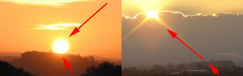
Apart from serving the function of an alignment marker through the Auckland Isthmus, the ancient mound atop Mt. Wellington (Maungarei ... which means "the watchful mountain") served as a vantage point for getting a very precise calendar fix on the day of the Summer Solstice. A distinctive trough, situated very near to the Manukau Heads, represents the southern-most position that the sun will reach annually before it turns to travel north again, up the horizon towards the Equinox and Winter Solstice.
ELEVATIONS ABOVE SEA LEVEL & DISTANCE CALCULATIONS
The Waitapu Valley at Maunganui Bluff, Northland is a veritable treasure trove of ancient purpose placed markers for astronomy and surveying. It’s quite easy to tell that Waitapu and adjacent valleys, ridges and hills were marked for the benefit of initiate students gathered in to learn the ancient navigational and cyclic-astronomical arts. The multiple surviving structures of the valleys include standing stone circles, ridge mounds designed to be seen as pimples on the skyline from great distances away, solar observatories for accurately determining the days of Solstices and Equinoxes, sighting pits for fixed position views onto the highest points of the distant terrain, obelisk, cairn and boulder markers that are precisely placed at significant positions, the use of “V” features in the landscape for staying abreast of changing degree angles and use of the sea horizon for height calculations.
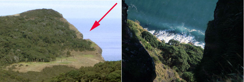
Left: On the sheer seaward cliff at Maunganui Bluff, the ancient Patu-paiarehe surveyors cut out a huge notch in the hard basalt-rock cliff. They excavated it so that a top edge line was perfectly level. Right: The vertical drop to the sea, many hundreds of feet below this carefully made excavation. The purpose of this laboriously cut cleft was to create a benchmark position that was situated a known, measurable distance above sea level and from this position calculate the heights of surrounding mountains or high ground.
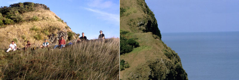
Left: A group of archaeological researchers sit along the top line edge of the cut notch. Right: A highly magnified view of the top line edge taken from a carefully placed trig stone far across the valley. Note how the sea horizon conjuncts perfectly with the top edge of the laboriously prepared and level excavation. On the opposite side of the valley are a series of precisely placed trig stones at ever increasing heights of the rising ground. By looking back to the cliff-notch from one of the trig boulders set at intervals up the hill, the observer is at a perfect level with the horizontal top edge (determined by a surveyor’s theodolite) and the sea horizon sits well below. One then moves to the higher trig boulder up the line and the sea horizon conjuncts perfectly as in the above picture.
This use of the excavation, at a known and measured height above sea level, combined with the use of simple water level devices, as well as vertical and horizontal angle measuring theodolites of simple construction, would be sufficient to determining inland elevations for cross-country land-mapping using trigonometry. It’s very obvious that the cliff-side excavation represented one end of a surveyor’s baseline of known length, which targeted the highest Northern mountain in view.
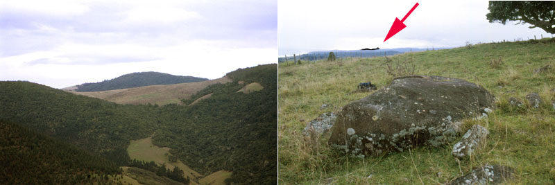
Left: Twelve thousand feet away, diagonally across the Waitapu Valley from the sea cliff notch is this carefully built and precisely placed mound. At some time a bulldozer driver, obviously unaware that the mound was an ancient purpose-built surveying structure, cut into the side of it. Circumnavigating the mound are marker cairns, some sighting pits and other individual marker boulders that relate to various special targets around the skyline. Right: From the mound one gets a clear view of the highest visible mountain Northwards (highly magnified picture). This view to the mountain is a rare occurrence in the Waitapu Valley, with about the only other vantage point being twelve thousand feet away at the sea cliff notch, which can also be seen from the mound and vice-versa.
The very measurable span of distance between the cliff side notch benchmark position and the mound represented an ancient, carefully prepared surveyor’s baseline. From each end of the baseline an exact angle shot was taken on the Northern mountain peak. With two known angles of reference, coupled with the known length of the baseline, the distance to the mountain could be very accurately calculated by trigonometry. Alternatively, using a water level-theodolite device of fairly simple design, ancient surveyors could, conceivably, have determined the slightly elevated angle up to the peak position of the Northern mountain, relative to the height above sea level of the cliffside notch. Again, by trigonometry, they could then work out the relative height of the mountain by careful calculations, some of which might have taken into account the curvature of the Earth over the interim distance.
Left: From the cliff side cut-notch benchmark directly above the sea the same high Northern mountain (enhanced) can be detected adjacent to the rapidly rising ground. This occurrence, in conjunction with the other angle fix from the mound, meant that distance and elevation calculations could be done relative to the mountain. Right: Another huge carefully placed obelisk situated in the next valley Northwards. It played a major role in the overland surveying endeavors and astronomy being taught to initiates.
Left: From a marker on the crown of Maunganui Bluff a line runs Northwards to the same high Northern mountain. On the first interim ridge the line crosses over a purpose-built standing stone circle arrangement, then proceeds to another giant obelisk adjacent to Puketapu cairn observatory. Right: The line crosses directly over the giant obelisk at Puketapu, then resolves upon the summit peak of the Northern mountain (enhanced).
The northern surveying target, by way of triangulations from each end of the baseline extending between the benchmark notch on the edge of the sea-cliff to the purpose built mound at Hood Road.
MORE USE OF THE “V” IN THE LANDSCAPE
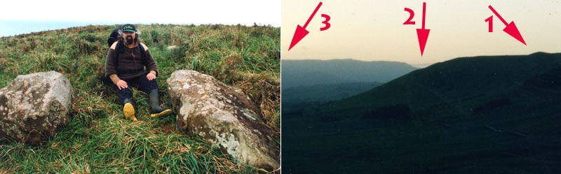
Left: The author sits between two of the huge component stones of the Waitapu standing stone circle (where very little is now left standing). To my left is the Southern hubstone of this dual hubstone observatory and the second hubstone reposes 96-feet further North. The very sophisticated observatory is made up of several hundred associated components, as well as cut platforms with stone retaining walls to accommodate some marker stones. Right: The view Eastwards from the Waitapu observatory at the time of the Equinox, just before sunrise.
(1) A huge purpose built pimple mound on the
lower Eastern plateau of Maunganui Bluff. This was of extreme importance for
multiple overland surveying functions, including one on Tokatoka Mountain South
of Dargaville. It also served as the outer marker for the summer Solstice sunrise
from an observatory low in the valley.
(2) A very exploitable “V” feature in the landscape,
formed by the near-in declining edge of Maunganui Bluff and the distant declining
edge of Tutamoe Range. The trough of the “V” represents 90-degrees
azimuth or due East from the Waitapu observatory, in the same way as from the
Waiwera solar observatory just North of Auckland. At sea level, from a beach
due East would be the rise position of the equinoctial sun, but because this
Northern sunrise at the Equinox has to climb up on an angle behind high terrain
the sun emerges further along Tutamoe Range at position (3).
Ancient surveyors or astronomers working from the Waitapu observatory could set their theodolites by reference to the “V” at 90-degrees azimuth and then take accurate degree angle readings of any other target on the horizon.
The repetitive use of the “V” formed by the declining edge of Maunganui Bluff and the further distant Tutamoe Range occurs several times in the Waitapu Valley. The hubstone of a standing stone arrangement that we have dubbed “the bush line observatory" relates to it in the same way as the more distant and elevated trig circle shown in the photo to the left. This is one of the only big, pyramidal trig stones still standing
To the right is seen the view from this trig circle. Note how the far more distant mountain is nestled perfectly in the “V”. This trig circle is also the most elevated of several rising trigs that relate directly to the "cliffside notch" (at known distance directly above the sea) situated far across the Waitapu Valley southwards. Using trigonometry, the elevation of the distant mountain (nestled in the "V") could be accurately calculated.
As earlier mentioned, there is a very large and laboriously built mound that juts up like a pimple on the Southern side of the Waitapu Valley. Alternatively on the Northern side of the valley are a series of trig obelisks that relate directly to the mound and mountains much further to the South. In the left-hand picture is seen one of 3 separate observation obelisks. In the right-hand picture is seen exactly why the obelisk was placed at that exact position. The arrow points to the sharp pinnacle mountain Tokatoka, sitting exactly behind the summit of the mound, 31.5-miles to the South.
It should be added that the obelisk marker seen above was in direct view of the sea-cliff notch, which sits a known distance above sea level. Again, by trigonometry, the elevations of each of the mountains within view to the South or East could be accurately calculated.
MORE SOLAR OBSERVATORIES
Left: The component parts of standing stone circle trig were drawn in and piled upon the huge centre hubstone by a farmer clearing scrub in the 1960’s or so. Right: By standing at the centre hubstone on the day of the Summer Solstice, the sun is seen to rise on the left edge of the huge purpose-built mound on Maunganui Bluff. Another standing stone circle trig further Southwest has the Summer Solstice sun rising on the right edge of the mound and climbing up the mound to the top before launching into the sky.
Left: Another large obelisk boulder lies towards the Eastern end of the Waitapu Valley. It was carefully placed there as a solar observatory for witnessing the Equinox sunrise in a “V” trough at the Southern face of Tutamoe Mountain. Right: The equinoctial Sun rises in the “V” trough formed by a nearer hill, against the background of Tutamoe Mountain situated some 16-miles distant. The Sun (god of the ancient "stone-builders" of New Zealand who were described as "uru-kehu" & "kiri-puwhero"... reddish, golden tinged hair - reddish, light complexioned skin ... with blue, green and other typically Caucasoid-European eye-colour tints) then climbs the face of the much venerated mountain before ascending into the sky.
These solar observatories lie scattered over the length and breadth of New Zealand in whatsoever locations ancient pre-Maori people settled in sizeable numbers. They were very important for checking and regulating the calendar, to keep all planting and harvesting optimised and happening on the correct days during the year, thus ensuring the greatest chance of abundant returns.
Researcher, Barry Taylor squats down in a specially built, ancient sighting pit at Tapapakanga Park, near Thames, NZ to observe the Southern Hemisphere's Winter Solstice sunrise on the distant Coromandel Ranges. From the hilltop sighting pit, which was built by the ancient Patu-paiarehe surveyor-astronomers, the Winter Solstice sun gives a very precise "first glint" fix in a conspicuous "V" trough on the range.
The ancient people built a large beehive house, hovel dome village at Tapapakanga, complete with two large ampitheatres, a stone-lined water course and many mounds or other structures in the sheltered valley by the sea. The late-era Maori warriors attacked them and survivors fled into the seclusion of the rugged Coromandel and Hunua Ranges to hide.
Down in the valley where the remains of the village structures are found, Barry stands on a specially built hump that relates to both the Winter Solstice and Equinox sunrises. An arrow is shown ascending from the sighting pit up on the hill where he earlier observed the Winter Solstice sunrise to occur on the Coromandel Ranges. From the valley hump position the sun rises from the hilltop pit. In other words, an individual standing in the sighting pit up on the hill became the outer-marker for another observer down at the valley hump to get a precise fix on the Winter Solstice day. The high ranges are often enshrouded in clouds, so this second, somewhat less accurate method offered an alternative fix.
From the purpose-built hump that Barry is standing upon, the view eastwards is onto this impressive geological feature on the distant Coromandel Ranges. On the day of the Equinox the sun rises on the magnificent outer marker and this bi-annual occurrence gave ancient New Zealand astronomers at Tapapakanga a very exact calendar fix for both the Vernal and Autumn Equinoxes.
The equinoctial sun launches itself into the sky from the position of the impressive geological feature on the Coromandel Ranges. This photo-event heralded the beginning of New Zealand's Autumn for 2010. Tapapakanga Park's purpose-built hump solar-observatory, therefore, works perfectly to give Winter Solstice and Equinox fixes and now only needs to be tested at the Summer Solstice to see if a clear outer marker exists for that solar event also. It would be impossible to state just how many of these solar observatories existed around New Zealand in ancient times, but the number would assuredly be in the thousands, if not the tens of thousands. Many survive and still work perfectly. Wherever an ancient, pre-Maori established community existed, a purpose-built solar observatory would invariably exist somewhere nearby to serve their calendar-correction needs.
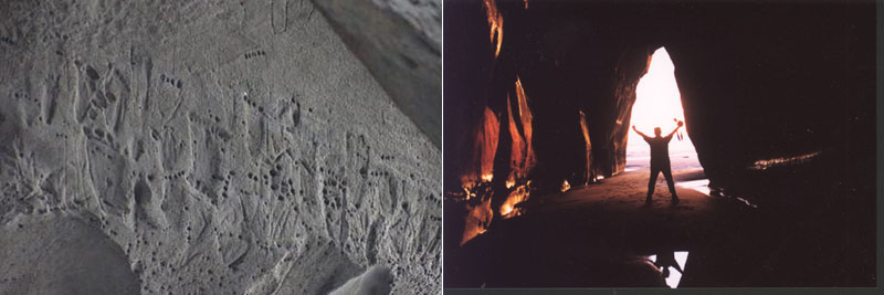
Left: At Tongaporutu, Taranaki there are the remnants of famous rock carvings of “feet”, showing counts of toes ranging from 4 to 6 per foot. The ancient arrangement would infer some kind of a counting system. Our archaeologists don’t seem to realize that the cavern with the rock carvings adorning the outer wall faces the position of the Summer Solstice sun as it descends and sinks into the ocean.
Right: Brendon stands near the cave entrance with the Summer Solstice sun alighting upon the sea directly behind him. There are many such natural sea caves in the area, but this one was, seemingly, chosen for the carvings because it gave a calendar fix on a very important solar event … just like at New Grange, Ireland where the sun enters a cavern corridor to accurately signal the Winter Solstice. In fact the event in New Zealand (the Southern hemisphere’s Summer Solstice and longest day) occurred on the same day as at New Grange (the Northern hemisphere’s Winter Solstice and shortest day). Perhaps the Tongaporutu carvings should have been carefully assessed for shadow play over their surface on the day of the Summer Solstice.
The carvings seen above were destroyed by high seas in May 2007. Local Maori spokespeople admitted the carvings were thousands of years old and stated: "They are the last signs of what we know as te kahui potama, which are the ancient people and they were known as the maeroa." See: http://tvnz.co.nz/view/page/423466/1219118
The ancient inhabitants of New Zealand had come from homelands in the Mediterranean basin and Europe and had passed through South America en route where they had lived for many centuries. With them they brought their astronomical and navigational skills, supported by their ages-old and highly advanced mathematical and calculating systems. In their ancient homelands, extending through Peru in South America and into the Pacific, their mathematicians used quippu string-knot calculators for recording special numbers. In ancient New Zealand these devices were called “kupu” or aho ponapona or aho tiponapona (also tau ponapona) meaning “many knotted cord”. In the oral traditions of the Maori wharewaananga (school of ancient lore) these were also known as the “string knot language”.
It seems apparent that certain early piu piu skirts or kilts, worn by the Patu-paiarehe astronomer-surveyors duplicated the function of the numbered strand/ string skirts carried or worn by Mexican or Peruvian officials, as seen by early Spanish historians. Each flaxen strand of the traditional Maori piu piu is intermittantly marked, and some earlier, special ones were undoubtedly number bearing, mnemonic devices. This fact related to the use of "kupu" (khipu or quippu) for record keeping by early Maori and throughout Polynesia generally is attested to in the "Tale of Whatonga" (See: Polynesian Mnemonics, by Elsdon Best, The New Zealand Journal of Science and Technology, Volume IV, No, 2, pp. 67-74, 1921).
Left: Tokatoka pinnacle mountain, which represents a major trig or fix point from many ancient standing stone sites. According to Waitaha legends, light and shadow effects form the face of an "old bearded man" near to the time of the summer Solstice ... and from direct observation this appears to be true. Right: A Peruvian quippu string knot device for preserving numbers. These were used in many parts of the ancient world, including the Mediterranean and Europe, the Americas and across the Pacific ranging to New Zealand. Some quippu's of South America are about 5000-years old.
The face of an old bearded man carved into a cliff above the channel leading to the sea at Whangape, Northland, New Zealand. The clearly carved face is huge and gazes towards the general positions of the Summer Solstice and Equinox rise points of the sun. The face itself was carved to be very deliberately fluted or channeled, causing a high degree of shadow play across the face between the time of the Summer Solstice to the Winter Solstice and throughout each day of the year. The Winter Sun would leave very long shadows on the face and an adept reader of the interplay between light and shadow would be able to fairly accurately determine both the time of year and the time of day. The pyramidal marker stone atop the head would have served the function as an observatory position for solar rises and sets. Accurate fixes on the Solstices (Summer & Winter) and Equinoxes (Vernal & Autumn) would have been calculated from that position and the calendar kept accurate accordingly.
Like the face of the old bearded man of Tokatoka, Ruawai, mentioned in Waitaha oral traditions, the face at Whangape sits adjacent to the deep navigable channel to the sea. These huge carvings obviously represented Tangaroa, god of the sea and ocean migrations. It seems reasonable to assume that mariners heading to the open sea would say prayers to Tangaroa and, upon a safe return, express their thanks.
Whereas the term "Mana" in the Maori language is used to describe the degree of an individuals accomplishments, intelligence and worth, etc., in the eyes of his or her tribespeople, the names Manannan Mac Lir, Mannanan and Manawydan a Lyr are the "God of the Sea" to the Irish, Scots & Welsh, respectively. In this regard the concept is not very different from Polynesia's Tangaroa/ Tangaloa veneration. This god was described in oral traditions of Polynesia as white complexioned with sandy coloured hair…whose offspring were the fair skinned moon-maidens and the greenstone folk (the fish of Tangaroa). He is said to have originally come from a land where the leaves stayed on the trees for only half the year).
It seems very evident that, given the copious amount of positively identifiable trig marking and surveying endeavors anciently undertaken in New Zealand, the local kupu (quippu) devices would have included SINE value numbers for trigonometry and very accurate land mapping. Calculating the log numbers for varying angles should have been reasonably easy to accomplish using, say, a giant 3,4,5 triangle drawn onto a washed and smooth beach-sand surface, then marginally adjusting the hypotenuse, adjacent or opposite (within the confines of a 360-degree circle) say a quarter of a degree at a time and measuring the changing length, then recording the result on a kupu (quippu).
People have to remember that for centuries before our present reliance on electronic calculators, we used logarithmic charts to provide the values for trigonometric calculations. Very often those complex distance, angle and elevation calculations were expedited and facilitated by use of manual abacus calculators that have been around for thousands of years.
Martin Doutré.
January 2009.