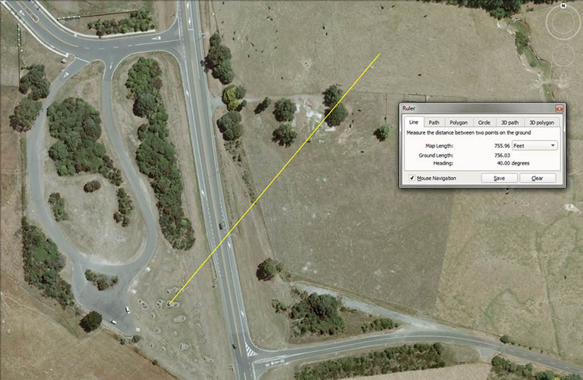
PYRAMID GEOMETRY.
In this year-2008 picture a pyramidal-shaped obelisk sits 756-feet from the hubstone at 40-degrees. The yellow line in the picture, beginning at the hubstone, traverses the first of the boulder line-up across the highway, which heads north along the fence. The line then crosses a mound to finally resolve upon the pyramidal shaped obelisk in the farm paddock.
The large pyramidal marker stone which, until 2009, sat 756-feet from the hubstone on an angle of 40-degrees.
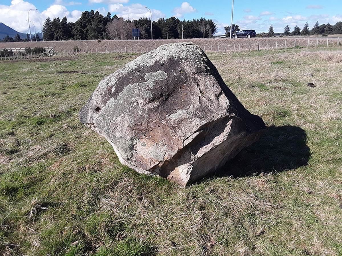
After that time a new bypass highway was built and this impressive boulder and a huge companion boulder were shunted 84-feet northwest to get them clear of road development. Thankfully, we still know their exact former positions in relation to the hubstone, based upon topographical photos from 1987, 1999, 2004 and 2008. In the background of this picture a car is seen travelling on the new bypass highway.
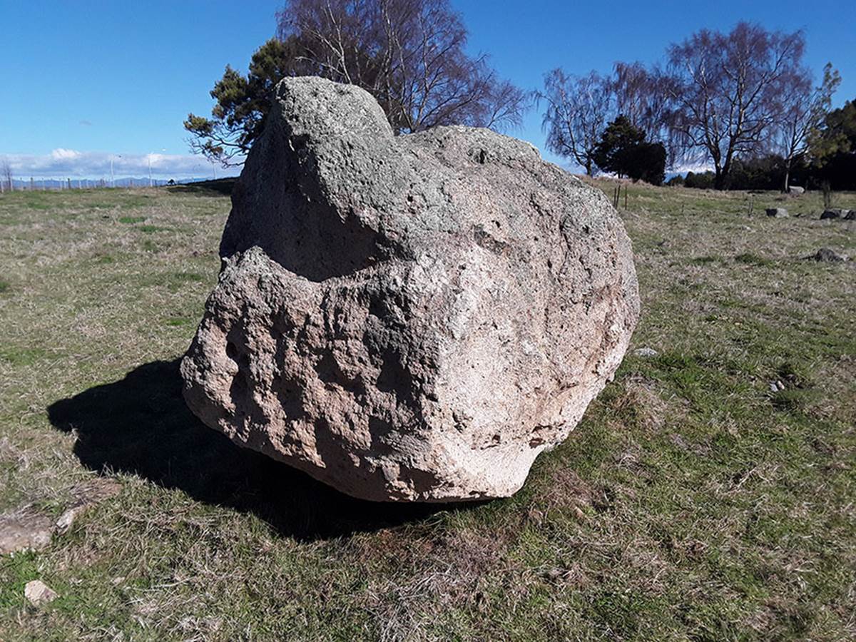
The impressive companion obelisk in the field that once sat 720-feet from the hubstone at a tipped-over angle of 40.5-degrees. Even on its side it’s 6-feet tall.
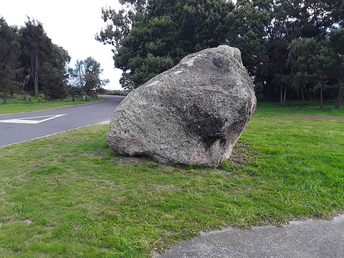
The largest obelisk of the entire site, even dwarfing the huge hubstone, is this massive boulder with an anciently hewn seat cut into it. Since 2004, it has lain beside the entry road into the Wharewaka subdivision, as, before that time, it totally obstructed the only possible access point for a new, two lane entry road into the subdivision.
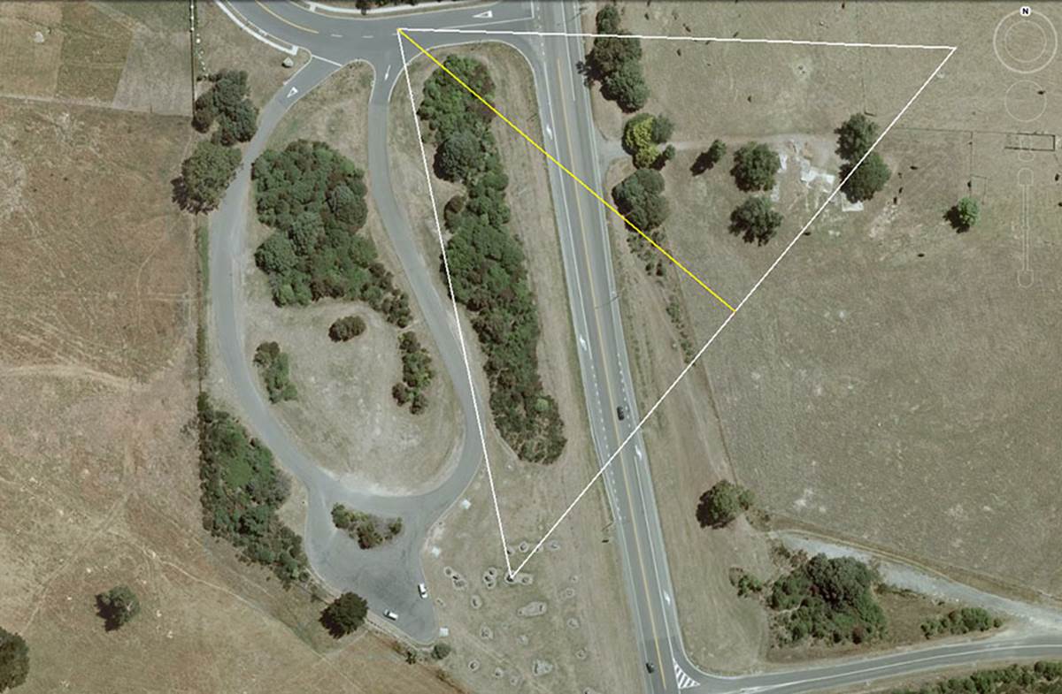
This 2-dimensional, precise replica of the Great Pyramid was clearly marked into the terrain at Wharewaka, Taupo with outer-marker obelisks at each corner. The pyramid design was offset from east-west by 50-degrees so that the base line ran from the hubstone to the northeast obelisk marker on an angle of 40-degrees. The massive boulder that once marked the apex of the pyramid geometry until the year 2004 sits off to the ESE, its former position now paved over with asphalt.
1. A mathematical progression based upon 756 goes:
756, 1512, 2268, 3024, 3780, 4536, 5292, 6048, 6804, 7560, 8316, 9072, … 11340, … 13608, … 18900, … 36288, … 54432, … 56700, … 130636800.
In the above line-up, 6048-feet is 1-minute of equatorial arc; 6804-days is the length of the lunar nutation cycle; 1306.8-MPH is the rotational speed of the Earth; 362880 is the number of feet in 1-degree of equatorial arc; 567-days would be 1/12th of the lunar nutation cycle; 130636800-feet would be the equatorial circumference (6048-feet X 60 X 360) under this navigational method.
2. A mathematical progression based upon 720 goes:
720, 1440, 2160, 2880, 3600, 4320, 5040, 5760, 6480, 7200, 7920, 8640, … 10080, … 10800, … 11520, … 12960, … 13680, … 17280, … 25920, … 51840, … etc.
The sum of 2160-years is the time the sun spends in each House of the Zodiac during the 25920-year cycle of the Precession of the Equinoxes; 7920-miles is the diameter of the Earth; 51840-feet is the circumference of a circle, with a diameter of 16500-feet (ancient English league) using PI @ 1728/550ths and this was of primary importance when travelling sea-legs in sailing ships and doing accurate positional plotting at the termination of each leg.
3. A mathematical progression based upon 40.5 degrees goes:
40.5, 81, 121.5, 162, 202.5, 243, 283.5, 324, 364.5, 405, … 486,… 567, … 648, … 729, … 850.5, … 891, … 972, … 1134, … 1215, … 1296, … 1458, … 2551.5, … 6804, … etc.
This progression is very useful in providing values applicable to lunar cycles being monitored within the lunisolar Sabbatical Calendar system. The sum of 40.5-days would be 1/63rd of the 2551.5-day lunar period (7.2-lunar years) being tracked alongside 7-solar years (2556.75-days) under the dual-count system. On the druidic Calendar of Coligny, blocks of 1890-days were monitored under the lunisolar system. These 1890-days could be divided by either 63 or 64 for reading solar or lunar periods concurrently. Therefore: 1890-days ÷ 64 = lunar months of 29.53125-days each … or 1890-days ÷ 63 = solar months of 30-days each.
SO WHY DID THE ANCIENT SURVEYOR-ASTRONOMERS MARK A 2D, FULL-SCALE REPLICA OF THE GREAT PYRAMID IN THE TAUPO TERRAIN?
The ancient New Zealand surveyors, setting out obelisk markers at purpose-placed, code bearing positions, needed to create a template for accurate angle work. Many of the outer-marker positions were a considerable distance from the centre hubstone, including the Taupo View Lookout array over 4.6-miles due north.
For the world travelling cousin civilisations, setting up new colonies or substantial civilisations on other continents far-removed from their Mediterranean/ Continental European/ British Isles countries, they carried special mathematical and geometric knowledge to the new lands they settled.
This was very old knowledge that had been encoded into positions of Egypt’s Giza Plateau, the former “Bureau of Standards” for the ancient cousin civilisations, whose forebears had abandoned Egypt, starting in about 5000 BC* when it got too arid.
The “out of Egypt” trails towards Continental Europe and Great Britain were still in evidence in the late 19th century, all along the Mediterranean Coast of North Africa to the Pillars of Hercules. There, the wayfarers crossed the narrow strait of water from North Africa to Europe and continued on the marked trails up the coasts of Spain, Portugal and France to Scandinavia, with some groups branching west to the British Isles or east into greater Europe.
*Footnote: There is a huge body of fully substantiated evidence that the Pyramids of Giza are far older than the phoney date assigned to them by our archaeologists and academics.
There is also much evidence to show very vibrant, trans-cultural diffusion and intermigrations between Egypt and the greater Mediterranean with the British Isles and Continental Europe, from remote antiquity and that all the countries encircling the Mediterranean Sea were once populated by long enduring, Caucasoid-European civilisations.
The formerly wet (savanna climate) North African region began to become increasingly arid because of the monsoons receding further to the south. This was due to the Earth’s tilt changing from 24.1-degrees 8000-years ago to 23.5-degrees today. After the Earth's tilt reached a critical point, the monsoons dowsing North Africa decreased and the vegetation began to disappear. With fewer plants available to retain water and release it back into the atmosphere, the rains declined ever more rapidly until desert conditions set in permanently.
Large segments of population, obviously realising there was no future staying in Egypt, turned their attention to and headed for the lush, vast territories of Europe, bringing with them the totality of their culture and sciences, including their weights, measures and volumes standards, tartans, kilts bagpipes, harps and Gaelic or related languages. Evidence suggests that the venerable oak tree, originating in ancient Egypt, was also carried to the new lands for transplanting.
The oldest mummies of Egypt are of Caucasoid, Europeans.
With the gradual abandonment of Egypt, starting in about 5000 BC, and its latter slow decline or subjugation by other invading groups, the only regions where the original mathematical and measurement systems that built the pyramids were preserved was amongst the European nations.
Very ancient waymark trails, composed of cairns, standing stones and dolmens were erected all the way across the top of North Africa, from Canaan-Israel-Palestine to the Straits of Gibraltar. The way mark trails (for travellers) continued up the coast of Spain, Portugal and France to Scandinavia.
'It is the view of many scholars that the general usage and scientific applications of standing stones or other types of stone landmark monuments, achieved their greatest sophistication in the British Isles, a region known to the ancients as the 'Isles of the West'. What remains of the ancient trails today points the way back to the place from whence peoples of the modern European nations came' (See Palestine, by Major C.R. Conder, R.E., George Philip & Son, 1889, pp. 142-157).
Further evidence of this mass migration out of the Near East / Middle East is found in Pre-Dynastic Egyptian skull types or those of Mesopotamia from 5,000 years ago. These can be matched to types found in 17th Century, London plague pits or Neolithic cist graves in Switzerland (See Races of Europe, by Professor C.S. Coon, Macmillan, N.Y., 1939).
Recently, scientists who managed to obtain full genome sequences of Ancient Egyptians for the first time have concluded the people of the pharaohs were more closely related to modern Europeans and inhabitants of the Near East rather than present-day Egyptians:
We find that ancient Egyptians are most closely related to Neolithic and Bronze Age samples in the Levant, as well as to Neolithic Anatolian and European populations (Fig. 5a,b). When comparing this pattern with modern Egyptians, we find that the ancient Egyptians are more closely related to all modern and ancient European populations that we tested (Fig. 5b), likely due to the additional African component in the modern population observed above. https://www.nature.com/articles/ncomms15694
For thousands of years the cousin nations had used standard techniques, encoded into the dimensions and angles of the Giza pyramids, to provide templates for surveying and calculating accurate angles within a 360-degree system. When setting up a sprawling open-air-university at Taupo, New Zealand, a century or two after the 186 AD volcanic explosion that had devastated the entire region, they would need to use the ages-old, standard template.
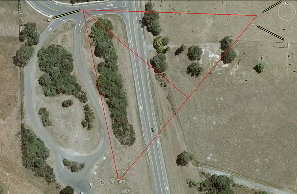
This is a perfect 2D replica of the Great Pyramid at Ernest Kemp Rise Park and an adjacent field across the highway, marked into the ground by giant obelisks on each corner.
By 2004 the largest obelisk of the entire region, marking the apex position of the pyramid geometry, was unceremoniously shunted 124-feet @ 252-degrees sideways to its present position in order to provide room for a road into the new subdivision development. An arrow shows how it was moved from its former to present position.
Other arrows to the right show where other giant obelisk markers resided until they also were shunted sideways by bulldozers in 2009. One marks the pyramid geometry corner @ 756-feet and the other, larger obelisk seems to have been tipped off-line @ 720-feet out from the hubstone.
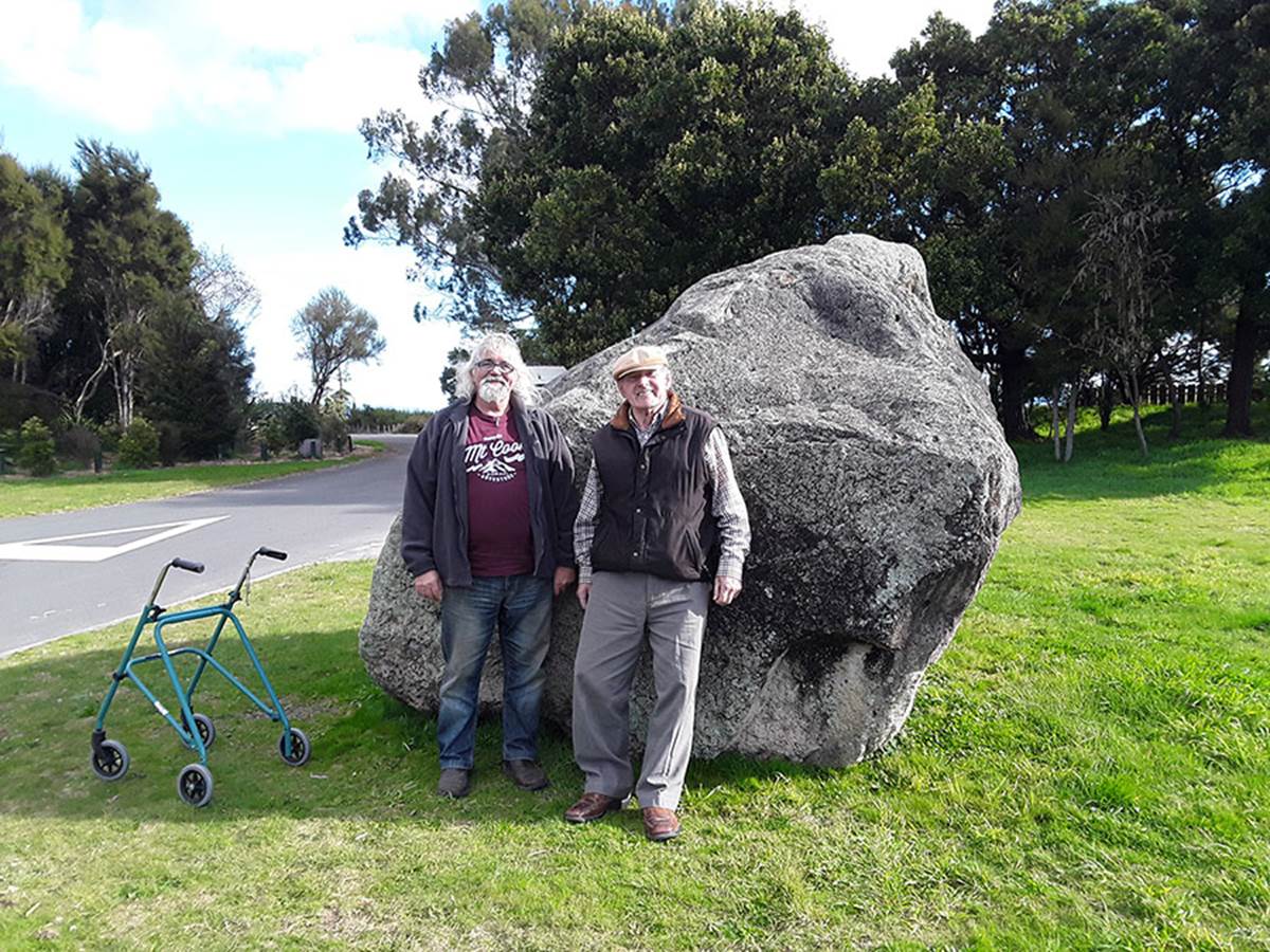
Senior citizen, academic and long-term resident of Taupo, Graham Parminter (right) well remembers the giant obelisk in situ, before it was moved by heavy machinery in 2004. He was present when it was moved. At ground level to Graham’s side can be seen the hewn-out seat and, further around the stone, the hewn-out footrest edge.
For several years prior to 2004, Graham Parminter had recognised features within the array of standing stones at Ernest Kemp Rise that were unnatural and suggestive of a purpose-built site. He was intrigued to discover a hand-hewn seat, complete with a foot rest, in the top of the huge obelisk and noted that anyone in the seat was looking directly at Taupo’s most lofty and impressive landmark, Mount Tauhara.
On and before the day of the obelisk move in 2004, Graham had carefully viewed from its position, down the line of smaller marker boulders to the hubstone, over 611-feet away, and committed the alignment permanently to memory, as he knew the original, in-situ, position was somehow very important.
He graciously showed us the exact, former position by moving across the new entry road, then orientating himself to be on the alignment of boulder-marked positions emanating directly from the hubstone. He then pointed to the spot on the asphalt where the giant obelisk had once stood upright for countless generations.
I must admit, I breathed a sigh of relief, as my calculations for a 2D replica of the Great Pyramid put the apex stone at that position.
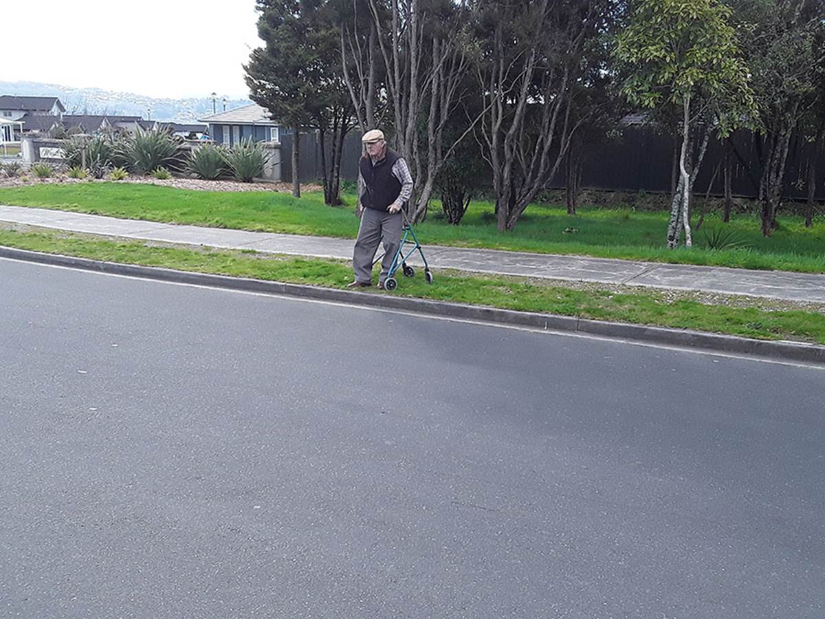
Graham Parminter getting himself into position to look down the line of stone markers, leading back to the hubstone just over 611-feet away, in order to orientate himself and finally fix onto the former position in the road where the giant obelisk once stood.
It’s a sad state of affairs when intelligent observers like Graham can readily see what’s so vividly in the landscape, whereas our so-called archaeologists, geologists and sundry gaggle of experts can’t detect anything of significance, so, in their ignorance, sign off sites like this for commercial exploitation, destruction and permanent eradication of the irreplaceable archaeological treasures.
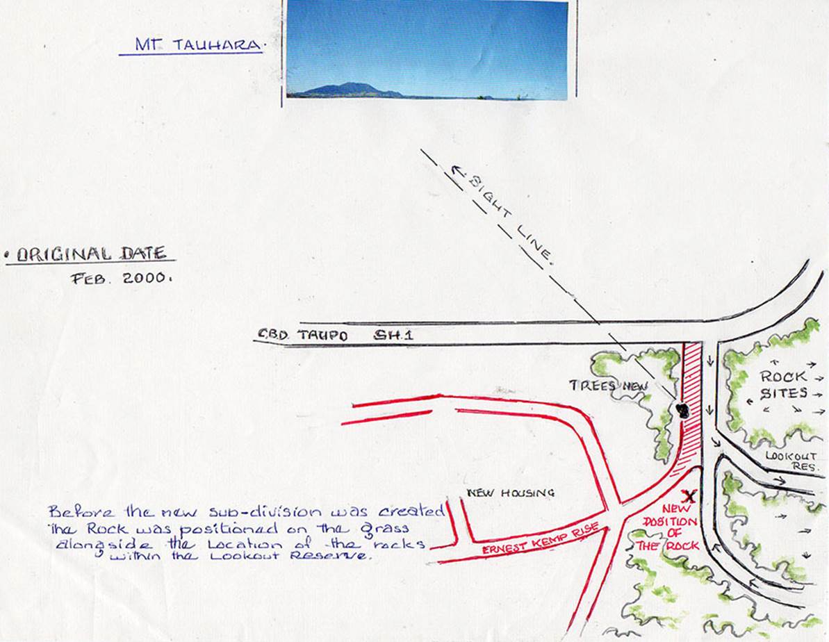
After showing us the former standing position of the giant obelisk, Graham went through his archives and found an old drawing he’d done as the new subdivision work commenced. With a red pen he drew in the extra lane that had to be built.
The giant obelisk formerly sat on a grass verge beside the much smaller-width entry road and the seat at its crown pointed towards Mount Tauhara. Graham had been intrigued and studying the general layout of obelisks since the year 2000.
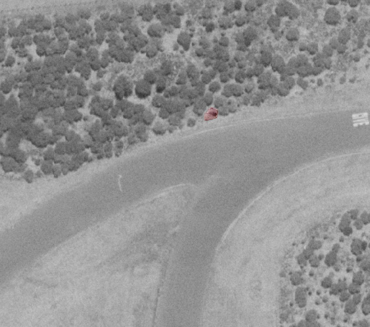
In the 1987 topographical photo the giant obelisk could be detected as a somewhat blurred object that presented as a definite shape.
A photo of, what had been, the top side of the obelisk before its excavation and move in 2004, was taken into Photoshop, cut-out around its perimeter with the lasso tool, rotated 20-degrees CCW, colourised reddish, reduced in size to 50 pixels then placed over its pixelated outline in the 1987 topographical photo. It fitted the perimeter perfectly and can be seen in the above photo, enhanced in a reddish hue. It sits precisely where it should in order to represent the apex position in a 1:1 scale, 2-dimensional representation of the Great Pyramid’s measurements and angles, marked into the Wharewaka terrain by large obelisks on each corner.
Of course, the obelisk had a second function as a surveying station in an overland alignment that ran from Mt Edgecumbe (Putauaki) 57-miles ENE … to the obelisk, … to the centre of Motutaiko Island in the middle of Lake Taupo, … across the high-point of Mt Tongariro … to Mount Cook (named Aoraki/ Aorangi at a late era of the 19th century) in the Southern Alps of the South Island.