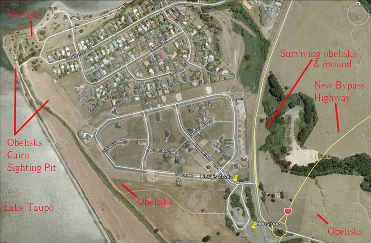
Thankfully, another very important part of the site 1/4th of a mile to the NNE is still largely intact, including a substantial ancient mound. Other component outer-marker obelisks survive to the east, ESE and 3/4ths of a mile to the NW. The coordinates reading in the photo relate to the position of the hubstone.
The area of study, where some original component obelisks, mounds, cairns & sighting pits of the ancient complex remain in situ.
A large subdivision, main road and a new bypass highway have caused many of the outer marker structures to be forever eradicated, but sufficient remains to show how the standing stone array worked.
Like the European megalithic sites, this was an “open-air-university” for teaching students principles of cyclic astronomy, the lunisolar calendar system, as well as the equatorial circumference of the Earth (for grid referencing - positional plotting) under two main navigational systems. The scientific principles encoded into positions within this site were used throughout the Mediterranean, Continental Europe and Great Britain, as well as North & South America in ancient times and taught generations of people how to navigate to far-flung climes, like New Zealand at the very ends of the Earth.
In the above picture the “hubstone” position is marked, as well as a giant obelisk with a seat carved into it, referred to as the “Devil’s Chair”. The dynamic function of that huge chair obelisk will be explained as we proceed.
THE CODES OF POSITION FOR THE OUTER MARKER OBELISKS & BOULDERS.
Firstly, it’s important to understand that the British Standard inch & foot have a very old pedigree, far more ancient than the known history of Britain itself. The self-same inch was used to build the Egyptian pyramids, the great standing stone complexes of Britain or Continental Europe, the temples and pyramids of South America, as well as the mounds and geometric earth embankment complexes of North America, etc., etc.
Archaeologist, J. Ralston Skinner, who undertook precise surveys of Ohio's geometric earth embankments in the 19th century concluded that the mound builders of the Ohio Valley had positively used the increment known as the British standard inch in the design and construction of the geometric complexes he surveyed. See: Skinner, J. Ralston. "Identification of the British Inch as the Unit of Measure of the Mound Builders of the Ohio Valley." Journal of the Cincinnati Society of Natural History Vol. 9 (July 1886), pp. 51-63.
All of the cubits or larger & smaller measurement increments of the great civilisations of antiquity in the Mediterranean and European theatres, as elsewhere, were based upon the same inch. The cubits or miles’ standards of one nation would be in direct ratio with the standard of another nation and commonly shared between cousin nations.
The special scientific information encoded by numbers into standing stone circles or mound complexes remains the same, continent-by-continent, wherever the ancient cousin nations went to set up civilisations or mining colonies. This fact remains true for the ancient inhabitants of New Zealand as well. We can trace the movement of a particular group of cousin nations across the world by the mathematical fingerprints they left in the landscapes.
So, let’s begin, using the same measurement and angle methodologies that we would apply if deciphering Avebury Henge in Southern England, Brodgar Ring in Scotland or the pyramids of Egypt, etc. :
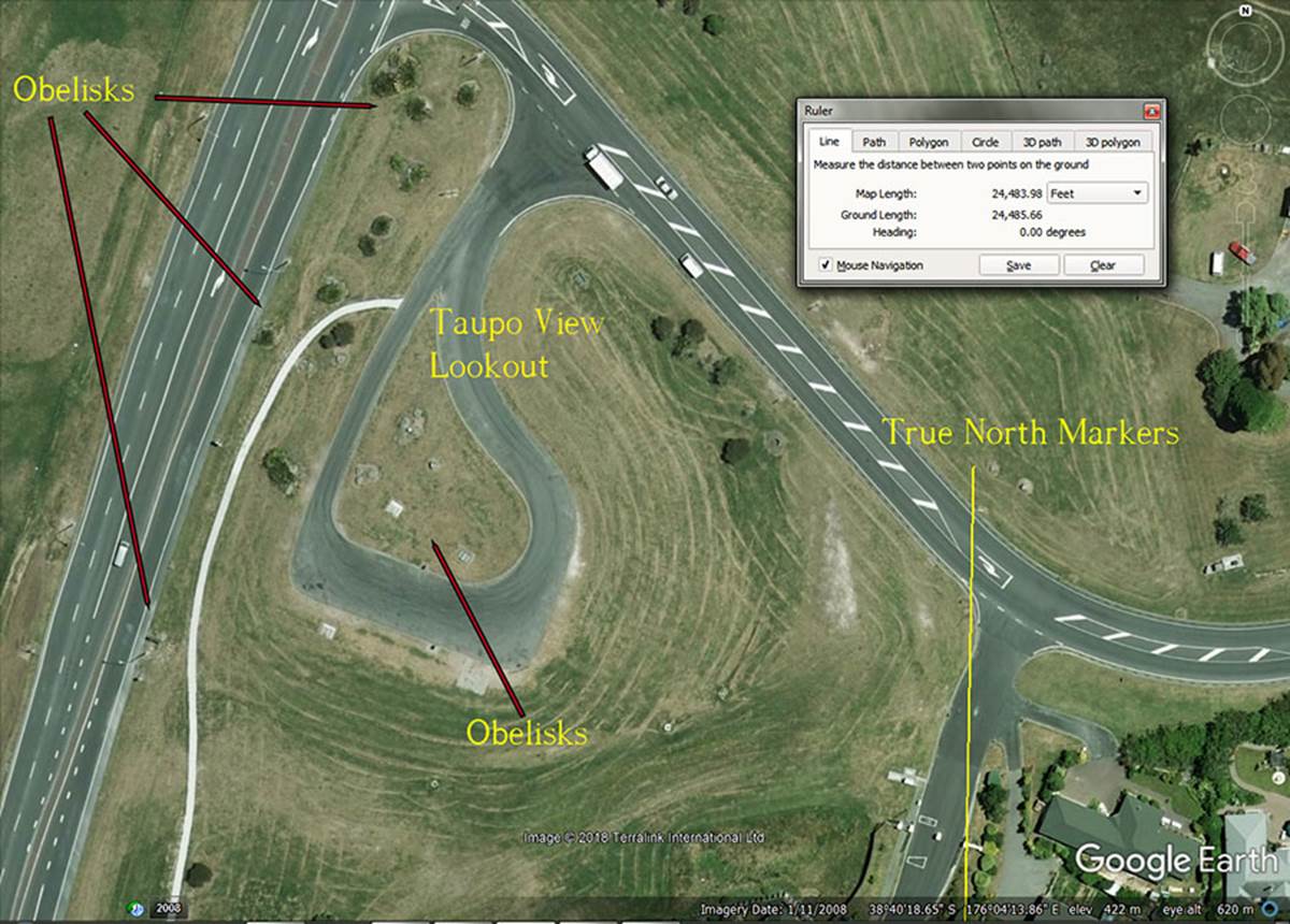
THE TRUE NORTH MARKERS
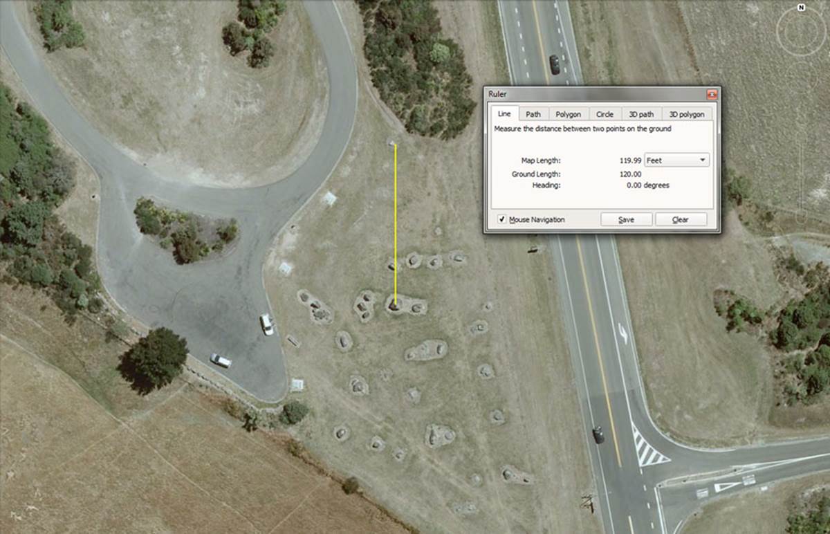
Situated 120’ due north of the hubstone is a fallen obelisk. The distance code for this on-site position would also have been read as 120.96’ & 121.5’. However, the ancient builders of the site established a far-distant true-north marker over 4 ½ miles away on a high hill for a very accurate reading on “True North”.
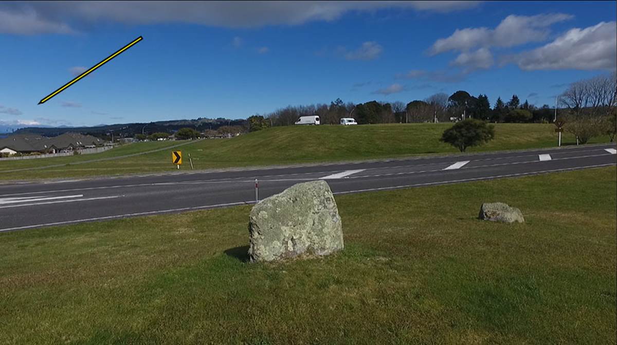
The True North markers, offering nearly perfect accuracy, are these two stones situated at Taupo View Lookout, at a distance intended to code or represent 24750-feet away (4.6875-miles …. 4 & 11/16ths miles of 5280-feet or 4 & 1/6th ancient Scottish miles of 5940-feet).
About 265-feet further north of this double-set of markers, on yet higher ground, a distance of 24750-feet from the hubstone was achieved. This distance would also be 14400 Egyptian Royal cubits of 20.625-inches each. Using the 20.625-inch Egyptian Royal cubit, 24750-feet would be 1/5280th of the equatorial circumference of the Earth under the “11” family of numbers navigational system.
The arrow at the top left points at the 3 snow-clad mountains of the Central Volcanic Plateau, situated between 40 & 50-miles SSW across Lake Taupo.
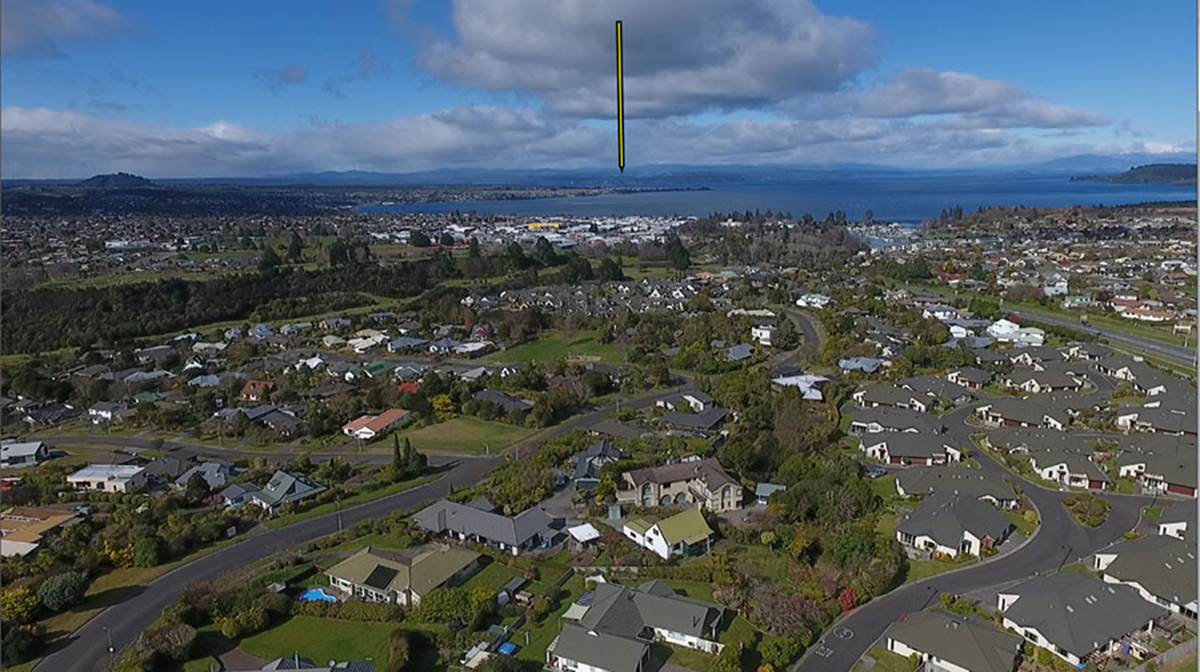
A vertical arrow points to the approximate spot where the hubstone of the Wharewaka standing stone array of obelisks is located, in relation to the due-north marker stones of Taupo View Lookout.
Taupo View Lookout on Huka Falls Road, an elevated part of the city with spectacular views over the lake to the majestic mountains beyond.
From this ancient assembly area, with its array of purpose-placed obelisk stones still in situ, Mount Tauhara is the outer-marker for both the summer solstice sunrise (southern edge) and equinox sunrise (northern edge) respectively. Coordinates at the bottom of the Google Earth picture pinpoint the location and this was obviously an outer-satellite site for the Wharewaka observatory located 4.6-miles due south.
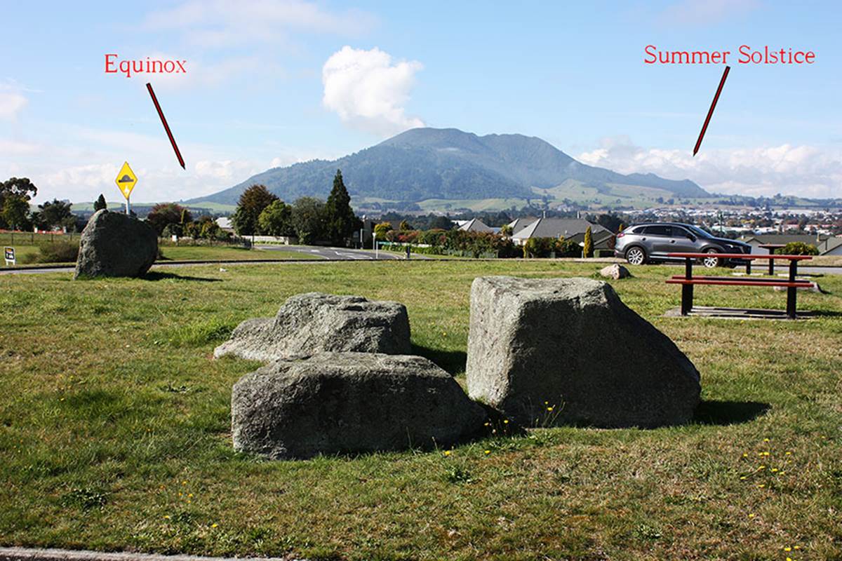
From the Taupo View Lookout there would be a very good fix on the summer solstice sunrise at the southern end of Mount Tauhara. The equinox sunrises (vernal & autumnal) would be slightly to the north of the mountain. This obelisk site sits on a return angle of 179.2-degrees back to the hubstone at Ernest Kemp Rise, Wharewaka and this value (1792) is a strong, ancient navigational code.
The large obelisk boulder to the left of the picture was undoubtedly the hubstone of this satellite mini-observatory, where further tutorials related to the numbers of civilisation could be taught to initiates (the brightest & the best of the children … the few set aside to bless the many).