STEPPING THE FIRST NORTHWARD BASELINE UP TO HIGHER ELEVATIONS.
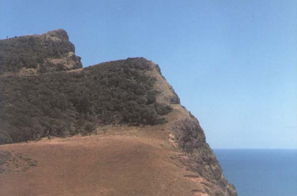
Figure 31: One can look toward the cliff benchmark from a series of carefully
placed boulder trig stone markers lying, at ever increasing elevations, on the
slope above the Waitapu standing stone circle observatory. A lower trig boulder
is on a perfect level with the cliff-face benchmark, which is situated 2268
feet southward. Viewing from the level trig vantage point southward the sea
horizon meets the cliff well below the benchmark. As stated, the line of view
between the two aforementioned positions represents a "baseline" for
surveying. This photo was taken from the southern hubstone on the Waitapu standing
stone circle observatory.
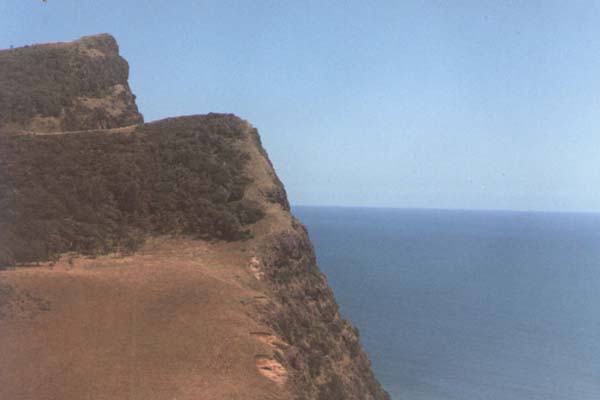
Figure 32: Above the observatory on the northern hillside are, as mentioned,
11 identifiable trig boulders at increasing levels of elevation. This picture
was taken from a higher trig before the final plateau-trig positions and shows
the sea horizon (datum) conjuncting perfectly with the benchmark. The sea horizon
represents a "constant" that will always provide reference to zero
elevation. In this case a trig boulder is indicating the slightly declining
angle downward, crossing the benchmark cleft at 960 feet of elevation, to finally
resolve onto the distant sea horizon.
|
|
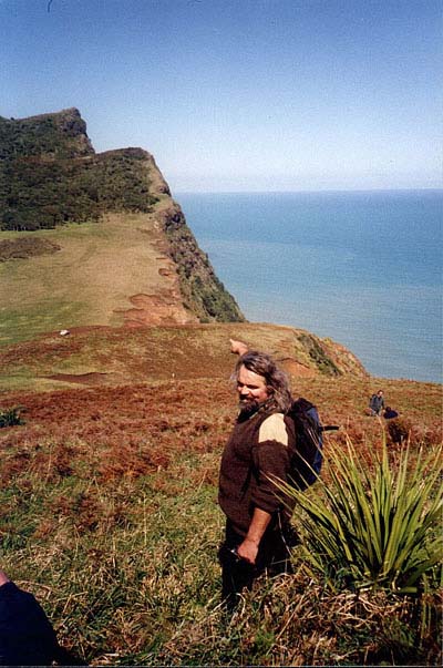
Another photo taken from the trig boulder that sits at a level wherein
the sea horizon conjuncts perfectly with the benchmark cleft. Further down
this same hill from which the author is pointing, reposes the trig boulder
that sits on a perfect level with, and 2268 feet removed from, the benchmark
cleft. As stated, the cleft sits a known elevation above sea level (960
feet). The uphill distance from the lower, "level" trig boulder
to this higher, "sea horizon" boulder is a precisely measurable
distance and elevation. From this information one can construct a series
of 'cross-valley, vertical triangles and make precise trigonometric calculations
related to both distances and angles.
Before the wide spread usage of electronic calculators, trigonometric calculations
had to be done by constant reference back to number charts. These logarithmic
charts listed the appropriate sine, tangent or cosine values that related
to particular angles that had been worked out by laborious manual calculation.
The Aztecs used quipu string knot devices to record numerical values. Quipu
knotted string bundles have been found in New Zealand and are preserved
in our museums or spoken of within the wharewaananga (Maori schools of learning)
as a form of language. It is quite possible that some New Zealand quipu's
were used for sine, tangent and cosine logarithmic reference. In New Zealand,
'the string knot language was called 'kupu" (like quipu).
(ref. Mana Cracknell of the Maori Wharewaananga).
|
Figure 33: The trig boulder that marks a conjunction between the carved
sea-cliff cleft (benchmark) and the sea horizon (datum) seems to have been intended
to sit a coded distance of 2333.333 feet from the benchmark cleft. This distance
is 1/3rd of 7000 feet. One of the marked distances from the benchmark cleft
to the tor mound plateau cairns situated on the Waitapu Valley's northern ridge,
was 12250 feet or 7000 Hebrew Royal Cubits (also known as Celtic Royal Cubits)
of 21-inches each.
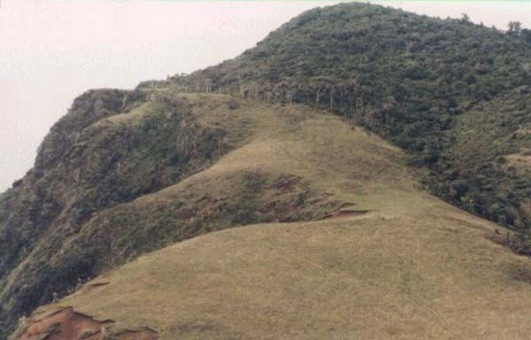
Figure 34: Looking north from the sea-cliff benchmark side of the valley.
Two tiny figures (centre right) are seen standing at the southern hubstone of
the Waitapu stone circle observatory. On the steep rising slope immediately
behind them are trig positions, marked by carefully placed boulders, at increasing
elevations up the slope. At the top of the slope is a plateau with four trig
positions on or adjacent to it and these align directly onto mountains to the
east and southeast. (Photo by Mark).
CODED DISTANCES AND ANGLES FROM THE BENCHMARK CLEFT ON THE SEA CLIFF TO
THE TOR MOUND PLATEAU ON THE NORTHEASTERN RIDGE OF THE VALLEY.
From the sea cliff benchmark the above sea level elevation was established
and the sought after figure appears to have been 960 feet. Unfortunately GPS
units, although they are very good at establishing latitude and longitude tend
to have difficulty with altitude and a reasonable degree of error (within the
range of 30 feet) can be expected. The ancient surveyors achieved their initial
reading of elevation above sea level by actual measurement and then calculated
the altitudes of more distant, higher targets by determining the degree angle
upward to them. It seems obligatory that the chosen level for the benchmark
would be a full, much-used number from the ancient parcel of coded values and
one that was both easy to remember and apply.
Within line of sight of the benchmark cleft, over once fully cleared terrain,
lies the north ridge plateau where a tor mound was raised. This tor hump resides
over two miles to the ENE of the benchmark cleft and its associated cairn markers
indicate that it was an alignment junction for coded distances and angles. The
end of the small plateau upon which the tor is situated can also be seen from
the southern hubstone of the Waitapu Observatory.
Let's shift our attention to the north ridge tor and the plateau upon which
it sits. We will attempt to find out the meaning of the markers placed there
and how they relate back to the benchmark cleft.
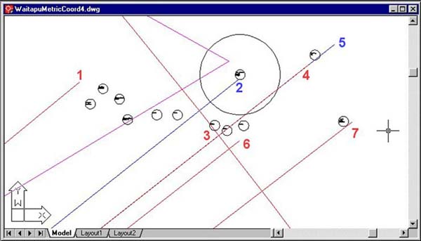
Figure 35: These are the plotted cairn and marker positions of the north
ridge tor mound plateau. Some positions relate directly to the benchmark cleft,
over two miles away WSW, on the seaward cliff. Others were placed there to relate
to markers to the south, such as those associated with the tor mound on the
southern ridge of the Waitapu Valley. Most lines shown emanate from the benchmark
cleft and are precisely (AutoCAD) correct in length and angle to suggest the
following premeditated design codes in the placement of the tor and its satellite
markers. The magenta elbow angling in (then out) is part of the huge equilateral
triangle running from the southern hubstone of the Waitapu observatory…
to the north ridge tor mound… then onward to a prominent boulder marker
on Puketapu's summit. The angle from the southern hubstone to this tor mound
is 59.0625-degrees and codes a major lunar code associated with the Khafre Pyramid
(the upward, diagonal length of each face from base to apex was 590.625 feet...
half of which is 295.3125... the lunar month was 29.53125-days). The cairn that
the magenta line crosses, undoubtedly, codes this angle information in its position.
- Somewhere in the approximate end of line 1 the terrain falls away steeply
toward the north and bracken encroaches upon the now dilapidated, lichen covered
former markers situated there. The line extending to this position from the
benchmark cleft is exactly 12000 feet and lies on an azimuth angle of 50.625-degrees.
Some markers are known to reside at this approximate position but have not
as yet been positively recorded with GPS. Several of the markers shown to
the right of that position (circles 6 metres in diameter) reside 12000 feet
from the benchmark cleft also. The use of this first angle (50.625-degrees)
is strongly suggested by a major site in the heart of the valley. It sits
on an azimuth angle of 50.625-degrees and at a distance of 5555 feet from
the benchmark cleft, which puts its length in a ratio of 1:2.16 to 12000 feet.
The number 2160 relates to the number of years it takes for the sun to travel
through one house of the zodiac in the precession of the equinoxes. It also
relates to the diameter of the moon in miles. The angle of 50.625 relates,
as a number, to the moon and is a part of a mathematical progression leading
to 354.375 and 708.75. The lunar year is 354.375-days and the Khafre Pyramid
of Egypt has base side lengths of 708.75 feet (50.625 X 14). The length of
12000 feet potentially provided an excellent surveying baseline from which
to calculate degree angles onto positions at of near the larger tor mound
to the south. The southern ridge tor could be seen from both the benchmark
cleft and the northern ridge. This baseline could be used for trigonometric
calculations related to the position of that southern valley structure and
its satellite markers accordingly.
- The line running directly to the tor mound from the benchmark cleft is
12250 feet and lies at an azimuth angle of 51.5454545-degrees. This is a septimal
length from the old "Celtic Royal Cubit" standard of 21 inches,
earlier used by the Hebrews. The pre-dynastic Egyptians, who built the structures
of the Giza Plateau, also used it, as the Great Pyramid is 432 Royal Cubits
(of 21 British Standard inches each) per side (756 feet). The 12250 feet length
from the benchmark cleft to the north ridge tor mound is 7000 Celtic Royal
Cubits. It's interesting to note that the distance from the tor mound to the
Puketapu cairn observatory is also 7000 Celtic Royal Cubits. The angle to
the tor mound from the benchmark cleft (51.5454545-degrees) is a coded expression
of 206.1818182 (¼ of that value) and the sexagesimal Egyptian Royal
Cubit rod was 20.61818182 inches long (see Turin Museum collection). This
is a major code related to the size of the Earth under the sexagesimal geodetic
system. The purpose of these "reduced size", geodetic Egyptian Royal
Cubit rods was devoted primarily to remembering the size of the Earth and
how to grid reference it for successful navigation. The 20.61818182 related
lengths were used in ancient Britain and are found at Stonehenge, but under
Roman and Roman Christian domination fell into disuse and were lost. They,
along with the PHI based measurements like the megalithic yard were once fully
a part of the British Standard of measurement, of which little now remains…and
if the European Union has its way, the age-old measurement standard, upon
which the Great civilisations from Sumeria to the Americas were founded, will
be banned from use by edict of law. Already, pig-ignorant, EU unleashed, metrification
enforcing goon squads are prosecuting those who persist in using the traditional
and very ancient weights, volumes and measures standard in England…a
system that was continuously employed in Britain and France for at least the
last 5000-years.
- This is a positive hit (red crossing line dissecting) of 12150 feet from
the benchmark cleft at an azimuth angle of 51.84-degrees. The 12150 feet length
is a dynamic lunar code (½ of 24300). The lunar nutation cycle was,
by the ancient mathematical system, calculated to endure for 6804-days or
28 periods of 243-days…which is 56 periods of 121.5-days. The Aubrey
Circle at Stonehenge had 56 post positions and was used for calculating periods
within the lunar cycle. The distance of 1215 feet was also positively coded
into the Octagon earth mound complex of Newark, Ohio. It is obligatory that
the degree angle of 51.84-degrees be found in the purpose placed structures
of the Waitapu Valley, as this is one of the foremost codes of antiquity.
The Great Pyramid face angles are 51.84-degrees, as is the azimuth angle throughout
the length of the Octagon complex of Newark, Ohio, extending for 2880 feet
from the Altar through the Avenue to the outer gateway ENE. The usages of
51.84 in the ancient astronomical and navigational systems of Egypt are many
and varied. Full explanations on how this and many other numbers were used
are covered in other articles within this website.
- 12375 feet & 51.84-degrees azimuth (½ the circumference of the
Earth with, "miles" substituted for "feet"… under
the "11" series geodetic system… and angle of the Great Pyramid's
faces). This distance and angle resolve upon the position of a sighting pit
depression, indicating that important surveying work was undertaken from here.
- One length code that was, undoubtedly sought after in this alignment to
a tor mound satellite marker was 12441.6 feet. There is another sighting pit
depression adjacent at a slightly greater distance to the one shown, which
is not as pronounced or impressive, but it probably coded 12441.6 feet. This
number codes two very important Earth size values under two varied geodetic
systems. The "reed" (10.5 feet) size of the Earth under the sexagesimal
geodetic system was 12441600 reeds). The mnemonic method for achieving this
Earth size was based upon multiplying the length of an Egyptian sexagesimal/
septimal Royal Cubit of 20.61818182 inches X 1200 and reading the resultant
total as miles. The Egyptians also used a rod of 1.728 feet or 20.736 inches
(indicated by paving slab measurements at the base of the Great Pyramid).
When the same formula was applied to finding that rod's rendition of the Earth's
size, the result was 24883.2-miles. This is very comparable to the equatorial
figure that we use today (ours is 24902-miles…or about 18-miles more).
Half the value of 24883.2 miles is 12441.6 miles.
- A code of 12175 feet, at an angle of 52-degrees, resides in this position.
The sum of 121.75-days is one third of the solar year and the year, under
the Sabbatical Calendar system was divided up into 52 weeks of 7-days or 13-months
of 28-days (364-days). This was the raw count agrarian system, allowed to
run for 7-years, then fully corrected at the end of every 7th year (Sabbatical
Year).
- This position appears to positively code 12375 feet at an azimuth angle
of 52.5-degrees. Under the "11" series geodetic system the circumference
of the Earth was 130680000 feet or 24750 miles and half that value is 12375
miles. As stated, under the other ("6") system the Earth's circumference
could be read in incremental values such as the "7" based reed (10.5
feet or 126 inches). The half value of 10.5 feet is 5.25 feet or 63 inches.
The reed value is one of the most useful and versatile of all ancient length
increments and it's highly likely that most rods of staffs carried by ancient
priests ("Masters of the Craft") were in half reed lengths of 5.25
feet. Such staffs could act in the capacity of calendar positional calculators,
used for staying fully abreast of both solar and lunar positions within the
very accurate Sabbatical Calendar system. A half reed ruler or staff could
also be used for calculating the progress of the moon throughout the 6804-day
lunar nutation cycle. The length of the Sarsen Circle lintels at Stonehenge,
on their inner faces, was 1 reed each of 10.5 feet. Every 6-degrees of arc
around the Sarsen Circle inner rim was 5.25 feet. The entire circuit (315
feet) was ½ a Greek Stadia (630 feet…or 30 reeds). Each base side
of the Great Pyramid is 72 reeds in length.
By now the reader will be getting some idea of the sophistication of the ancient
astronomical/ navigational/ calendar system of the Northern Hemisphere, originating
from or later fully resident in Egypt, Sumeria and Babylonia, then spreading
to Continental Europe and the Americas, before finding its way into Oceania.
In seeking to identify a Northern Hemisphere civilisation, whose structures
most closely compare to the types of ancient structures we're finding across
New Zealand, one is drawn to Megalithic and Neolithic England, Ireland, Scotland,
Wales, France and Scandinavia. Cultural symbols in the possession of Maori Polynesians
of New Zealand are ancient European and Mediterranean in origin and were acquired
by them when they recently conquered an earlier, long established New Zealand
civilisation.
Let's now look at coded distances and angles flowing to the northern ridge
tor mound from the southern ridge tor.
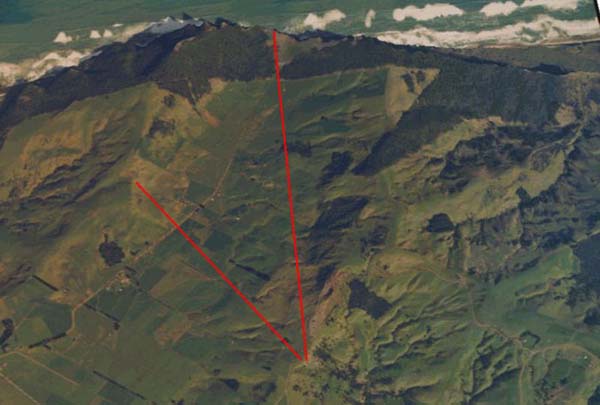
Figure 36: A line extends from the benchmark cleft on the sea-cliff to the
tor mound plateau on the northern ridge of the Waitapu Valley. Another line
runs between the two tor mounds situated on the northern and southern ridges.
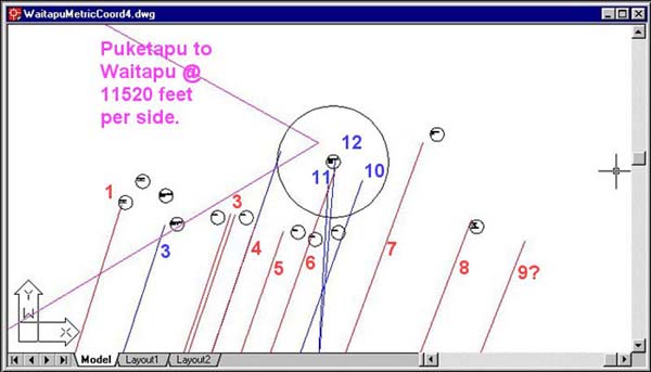
Figure 37: We now move our attention to coded distance alignments and angles
between the northern ridge tor and its counterpart, the southern ridge tor,
some 8000 feet away toward the south. On the steep northern face of the southern
ridge tor the ancient surveyors built a large dark stone bulls-eye. It looks
a bit like an oversized truck tyre lying on the steeply inclined ground and
now has a small tree growing in its centre. The bulls-eye is visible for miles
from hills situated in the north. Lines depicted flowing onto the north ridge
tor plateau in the above AutoCAD picture originate from the bulls-eye across
the valley.
- This first distance is 7776 feet and codes a special lost measurement called
the megalithic yard. The true megalithic yard was based upon the PHI ratio
(1.6180339) and was composed of 20 standard inches X PHI or 32.360678 inches.
Although the pure PHI measurement had to be used in situations where it was
necessary to lay out circles in a pure PHI reduction (such as at Stonehenge…(i.e.)
Aubrey Circle diameter ÷ by PHI = "Y" Holes Circle diameter
÷ PHI = Sarsen Circle diameter, etc.), it was also common to use a
"rounded PHI" increment of 32.4 inches. This 7776 feet distance
can be dual read to mean 2880 rounded megalithic yards of 32.4 inches or as
7766.56272 feet (2880 megalithic yards of 32.360678 inches). It was very important
for the ancient mathematicians to remember PHI, (although it was a difficult
number) and ancient structures like the Great Pyramid were built to comply
as close to PHI as possible. As an example, the Great Pyramid has a base side
length of 756 feet. This is 280 "rounded" megalithic yards of 32.4
inches each or 560 "rounded" ½ megalithic yards of 16.2 inches
each. To those encrypting codes into the Great Pyramid, this close proximity
compliance to pure PHI allowed the structure to be dual coded and able to
be symbolically read in pure PHI increments. The 7776 feet distance between
the Waitapu Valley tor plateaus is, as stated, 2880 "rounded" megalithic
yards and the 288 number was of extreme importance in the ancient parcel of
coded values. The diameter of the Aubrey Circle at Stonehenge is 288 feet.
The overall design length of the Octagon of Newark, Ohio is 2880 feet. The
diagonal length of the Menkaure Pyramid from its base to its apex was 288
feet. The length up the side of the Great Pyramid to its flat floor altar
(it never had a capstone) was 576 feet (288 X 2). The Geomancer's Mile of
ancient Britain was 14400 feet (½ of 28800). The Egyptian Pyramid acre
was 28800 square feet. At the Octagon earthmound complex of Newark, Ohio,
the distance from the centre of the Octagon's circle component to the centre
of its octagonal component is 576 (288 X 2) rounded megalithic yards or 1555.2
feet (777.6 feet X 2). The 7776 feet distance across the Waitapu Valley from
the tor mound to the marker on the opposite plateau is, therefore, exactly
5 times the Octagon's centre-to-centre distance. The degree angle of 17.5
feet for this alignment is one of the most used ratios of antiquity (1.75).
The Menkaure Pyramid at Giza is 1.75 less in base length than the Dashur Pyramid
at Saqqara. The 1.75 ratio was used for converting "7th" parts of
a 360-degree circle into readable, workable, whole number values…hence
360-degrees ÷ 7 = 51.42857143 X 1.75 = 90. One can also express this
as 360-degrees X 1.75 = 630. This is why ancient calendar calculators like
the Brasen Sea of the Temple of Solomon were fabricated to be 630 inches in
circumference. Similarly, the inner rim of the Sarsen Circle at Stonehenge
was 315 feet (½ of 630 feet and thereby ½ of 1 Greek Stadia).
The length of a Greek Stadia, is marked into the running track at Olympia,
Greece.
- The next marker was probably fashioned to be 2880 true megalithic yards
from the tor mound bulls-eye or 7766.56272 feet away at an azimuth angle of
18-degrees. The azimuth angle 180-degrees opposed to 18-degrees is 198-degrees
and this codes the "league" circumference of the Earth, which was
7920 leagues (of 16500 feet each) under the "11" series geodetic
system. The league length for each "quarter" of the Earth under
this system was 1980.
- The next 4 markers appear to be 7812.5 feet from the bulls-eye, the first
of which was probably coded to lie at an azimuth angle of 18.613-degrees.
The 7812.5 feet distance relates to a much-used ratio. Under the "11"
series geodetic system the ratio difference between a "mile" and
a "league" was 1: 3.125. The mile was 5280 feet and the ancient
league was 16500 feet. There is a marked expression of the ancient league
in the Waitapu Valley region. It runs from a boulder cairn on the summit of
Puketapu hill to another boulder marker on Maunganui Bluff's lower ridge-line
near the southern ridge tor mound. The distance of 7812.5 feet is 1/4th of
31250 feet and codes this very important mathematical progression of numbers.
The azimuth angle is probably 18.613-degrees…coding 18.613-years…the
duration of the lunar nutation cycle, from major standstill of the moon until
recurrence of major standstill. Sitting beside this expression of 7812.5 feet
is another at 18.66666-degrees azimuth (1/3rd of 56). The number 56 was used
for calendar, lunar or solar cycle counting and 18.66666 was integral to that
process. There are 56-post positions on the Aubrey Circle at Stonehenge.
- This time the 7812.5 feet line lies at 18.9-degrees azimuth. The 18.9 code
was very important to the ancient parcel of numbers and the Great Pyramid
was 189 feet X 4 long. The lunar cycle of 6804-days was 36 periods of 189-days.
The 2551.5-days of the lunar cycle within the Sabbatical Calendar count (7.2
lunar years) is 13.5 periods of 189-days. The number is of such immense importance
to the ancient universal system that it seems obligatory it be coded into
a marker.
- A 7812.5 feet line was possibly meant to lie on an angle of 19.2-degrees…another
very important and much used number in the "6" series.
- This is a very positive, dynamic code running from tor mound to tor mound.
The distance is 7920 feet. Under the "11" series geodetic system
of navigation the Earth was considered to have a circumference of 7920 leagues
of 16500 feet each. Under that same system the Earth was considered to be
7920-miles in diameter (which it literally is). Both the "6" series
geodetic system and the "11" series system were based upon reading
the perimeter value of the Great Pyramid as ½ a minute of Earth circumference
arc. Under the "6" system the pyramid was (literally) read as 3024
feet in perimeter value. Under the "11" series (league, furlong)
the pyramid was (symbolically) read as 3025 feet. These values were then multiplied
by 43200 to calculate the full 360-degree circuit around the Earth (360-degrees
X 60 minutes = 21600 X 2 = 43200). The ancient mariners knew that these two
systems were slightly short of the true equatorial circumference, but the
systems worked perfectly in mathematical progressions and were extremely versatile,
as well as very close to the true Earth circumference. The ancient Egyptians
used a slightly larger Royal Cubit of 1.728 feet, which under their mnemonic
system told them the true equatorial size of the Earth. Navigation, however,
was very successfully and accurately undertaken using the "6" and
"11" geodetic systems and chart plotting during transoceanic voyages
was based upon them. Linear distances covered were plotted in 11 series numbers.
These linear distances, when converted to circumferences became sexagesimal…hence,
1 league of 16500 feet travelled converted to 518400 feet of circumference,
which could be divided by 360 degrees. By this means angles from point of
departure to destination could be plotted regardless of the number of course
changes. The azimuth angle to the centre of the north ridge tor mound is 19.5-degrees
and this is an important number associated with the Sabbatical Calendar (which
functioned in part to expressions of 13). Another true angle associated with
this 7920 feet alignment seems to have been 19.8-degrees, which would have
brushed the edge of the tor. The league circumference of the Earth, at 7920,
is 1980 X 4.
- This alignment runs for 8000 feet from the south ridge tor to a sighting
pit and conspicuously forms a surveyors baseline for degree angle observation
onto mountains to the east and north. This pit was a very specific work-station
for the surveyor to sit in and from here distance, angle and elevation to
overland targets were determined. A prominent northern mountain that could
be seen from both the benchmark cleft and this pit was the much-targeted mountain
at Pungaru. Therefore, another surveyor's baseline of 12375 feet (the Earth's
circumference under the "11" series geodetic system was 12375 miles
X 2) ran to this pit from the benchmark cleft on the sea-cliff at an azimuth
angle of 51.84-degrees. The azimuth angle to this pit from the tor mound on
the southern ridge was 20.25-degrees. This relates to a very important ratio
used in calculating the progress of the moon within the Sabbatical Calendar
system. The Sabbatical Calendar ran for 7 solar years and this period equated
to 7.2 lunar years plus 5.25-days. (2556.75-days). The lunar count within
this period (2551.5-days) could be done in increments of 20.25, 40.5 or 81-days.
The 5.25-day difference between the 7 solar years and 7.2 lunar years is why
the ancient Druids had the mistletoe ceremony on the sixth day after the winter
solstice…5.25 days is into the sixth day…it was so that the calendar
count would end for both the sun and moon on the same day 7 solar years later.
- This alignment runs for 7920 feet, at an azimuth angle of 21-degrees, to
a vague but recognisable cairn at the eastern end of the plateau. Beyond this
point the ground slopes down to the east. The position of this cairn makes
perfect sense, as it is, once again, in mnemonic reference to the "league"
circumference and "mile" diameter of the Earth under the "11"
series reading. The 21-degree angle relates to the copious usage of "21"
in septimal renditions of length, such as the reed (6 X 21 inches) or Hebrew/
Celtic Royal Cubits (21 inches).
- Although no effort has been expended as yet to verify the theory by locating
a marker at this position, it seems plausible that the ancient surveyors would
have wanted to record the azimuth angle of 21.6-degrees. The number 2160 was
very important to the ancient astronomical/ mathematical system, which described
the moon's diameter as 2160-miles and the time it took the sun to move through
a house of the zodiac as 2160-years. On a future trip to the northern tor
plateau we'll check this intriguing possibility.
- This line is 7920 feet long and is set to 19.8-degrees. The sum of 7920
÷ 1980 = 4. The alignment probably (visually) brushed the eastern edge
of the shaped tor's upper structure. The distance of 7920 feet is 12 furlongs
or 1440 fathoms.
- This is an altogether different alignment not associated with the southern
tor, but now extending from an impressive boulder cairn that sits beside the
Telecom road on Maunganui Bluff's lower ridge. In both distance and angle
the alignment is coding the ratio PI. At the Crosshouse of Miringa Te Kakara
near Bennydale, N.Z., some positions were set out at spacings of 7.854 feet
and a combination of 4 such positions totalled 31.416 feet. This was in very
obvious reference to the PI ratio, which records that the circumference of
any circle is 3.1416 larger that its diameter. The distance from the boulder
cairn on the ridge to the tor mound centre is 7854 feet at an azimuth angle
of 3.1416-degrees.
- The length of this alignment from yet another, smaller boulder cairn on
Maunganui Bluff's lower ridge to a position on the northern tor was, undoubtedly,
to code the distance of 7812.5 feet at an azimuth angle of 4.66666-degrees.
The 7812.5 feet length would be in deference to a mathematical progression
that produces the number 3125. This was another form of "rounded"
PI used to describe the dimensions of the Earth under the "11" series
geodetic system. In that system the circumference of the Earth was 7920 leagues
and the diameter of the Earth was 7920 miles. The league was 16500 feet and
the mile was 5280 feet…or 3.125 miles to the league. The 3.125 ratio
was sometimes used to demonstrate how an observatory circle circumference
was to be calibrated in terms of its diameter. An example of this is found
at the Aubrey circle at Stonehenge where the diameter is 288 feet. This, translated
to a calibrated circumference, using the ratio 3.125, achieves 900 feet, which
would have meant using the circuit as 30-inches per degree of arc. A true
circle of 900 feet (10800 inches) might have been implied by the inner faces
of the 56 posts that circumnavigated the Aubrey Circle. The azimuth angle
of 4.66666-degrees is important within progressions of "7" and 4.66666
X 3 = 14. This ratio would have proved useful when working in septimal increments
like the reed (10.5 feet) or Hebrew/ Celtic Royal Cubits (21-inches).
As an added bonus, there is tremendous significance in the way in which these
two solitary boulder cairns of Maunganui Bluff's lower ridge-line are situated
in relation to each other. The distance appears to have been intended to convey
207.36 feet. This is a special geodetic increment based upon an Egyptian Royal
Cubit of 20.736 inches (1.728 feet) and this sized increment is inferred in
the dimensions of paving slabs at the base of the Great Pyramid. The Egyptian
Royal Cubit's length was multiplied by 1200 and the result achieved was read
in miles. This gave the circumference of the Earth, as read by that particular
type of cubit. There were predominantly 3 types (a) 20.61818182-inches (sexagesimal
geodetic reading), (b) 20.625 ("11" series geodetic reading) and 20.736
(true equatorial geodetic reading).
Measurements taken at Teotihuacan in Mexico show that an increment estimated
to be very close to 3.456 feet was primarily important. This length is 1.728
feet X 2 or a total of 41.472 inches. One standard length (estimated to be 1.059
metres) has been named the Hunab and was likely an Egyptian Double Royal Cubit
(based upon or related to a single Egyptian Royal Cubit of 20.736 inches). At
Teotihuacan there were recurring instances of 378 X 1 Hunab, culminating in
lengths around 1306.368 feet. This was in deference to the size of the Earth
under the Egyptian sexagesimal geodetic system, which was 1303680000 feet. Similarly
the "11" series size of the Earth was 130680000 feet and some of the
Teotihuacan lengths were, undoubtedly, expressing 1306.8 feet. There was yet
another "literal" size of the Earth, under the Egyptian system, of
131383296 feet and some of the Teotihuacan measures might best be described
as 1313.83296 feet. The small differences in the Egyptian Royal Cubits were
due to each coding a slightly different Earth navigational system.
The expression of 378 Hunabs occurs on each side of the square enclosure called
the "Citadel Complex". Remember that the azimuth angle from the benchmark
cleft at the Waitapu Valley to its level trig (2268-feet distant) is 345.6-degrees
and that the outer rim of the Sarsen Circle at Stonehenge was 345.6 feet in
circumference. It's also significant that Hugh Harleston's measurement at Teotihuacan,
from the south platform to the north row of buildings, is given as 2268 Hunabs
(6 x 378). The number 2268 relates to the 6804-day lunar nutation cycle and
is 1/3rd of that value (3 sides of the Great Pyramid @ 756 feet per side = 2268).
Just as there were 3 slightly different Egyptian Royal Cubits in common usage,
there were, undoubtedly, several marginally different types of Hunabs, one of
which was literally 20.736 inches or 3.456 feet. The Pyramid of the Sun at Teotihuacan
is said by Harleston to be 216 Hunabs long. The moon is 2160 miles in diameter
and the sun spends 2160 years in each house of the zodiac during the cycle of
precession.
The Aztecs also had a measurement called a Betan, which was 7/8ths the size
of the Hunab, or estimated to be very close to 3.024 feet. The Great Pyramid
has a base perimeter value of 3024 feet, which, under the sexagesimal geodetic
system, represented ½ a minute of Earth circumference arc. The distance
recorded by Hugh Harleston at Teotihuacan as 2268 Hunabs also equates to 2592
Betan. This was the number used to describe the duration of the precession of
the equinoxes (25920-years). It was also used in navigation when voyaging in
"league" linear distances (half the circumference of a circle based
upon a league diameter is 25920 feet). The distance from the centre of Stonehenge
to the outer face of the Heel Stone is 259.2 feet.
Here in New Zealand the ancient people used these Egyptian/ South American
measurements, as well as the Aztec quipu string knot devices, which were called
by virtually the same name locally (kupu). Many regional plants (Karaka Berry),
tubers (Sweet Potatoe) or cultural symbols (Hei-Tiki) found to be in the possession
of Maori when maritime explorers arrived in the 1700's have origins in South
America. The Waitaha people of New Zealand claim a link to South America via
Easter Island.
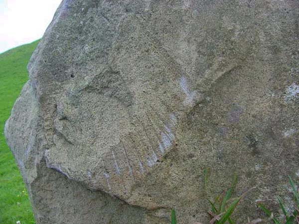
Figure 38: One of many incised boulders from the Taranaki region of New
Zealand's North Island, showing a raised relief face and headdress profile.
Boulder incised designs of that district can look very "South American"
and the headdress design shown is quite reminiscent of that depicted on the
Quetzacoatl plumed serpent representations at Teotihuacan or the striped effect
of Tutankhamun's funerary mask from Egypt. The Meso-American "feathered
serpent" representations also depict the "double spiral", much
used in Maori facial tattooing. The widely used "double spiral" design
has a pedigree back to ancient Ireland or the Caucasoid "mummies of Urumchi",
China, etc., and is very old. The intricate pictographs found on these Taranaki
boulders are generally faded and weather-worn, insinuating great age. Knowledge
of the boulders is muted and largely suppressed in New Zealand and to date there
has been little serious scholastic effort to trace the origins of the intricate
patterning found on some of them.
The distance between the 2 cairns is 120 Egyptian Royal Cubits of 20.736 inches
each (or 60 Hunabs). The other two types of cubits ("6" & "11"
series) are equally inferred. Using the formula to find the size of the Earth
by this particular cubit (20.736 inches) gives a rendition of 24883.2-miles.
The azimuth angle that these two cairns lie on in relation to each other is
288-degrees or (180-degrees opposed) 108-degrees. Both of these numbers were
highly important to the ancient system of astronomical/ navigational mathematics,
with such things as the Aubrey Circle at Stonehenge being 288 feet wide and
translating to 10800 inches of circumference when the diameter was subjected
to the 3.125 ratio. The smaller of the two boulder cairns lies 16500 feet (1
ancient league) from a marker on Puketapu Hill.
SUMMARY FOR STAGE 1 OF ANALYSING THE STRUCTURES OF THE WAITAPU VALLEY REGION.
Again, the results are predictable and consistent without any manipulation.
The job of this researcher and his colleagues is relatively straight-forward.
We simply go to a location and take fixes, knowing full well that the cairn
and other markers were placed there in antiquity for a reason.
The measurement standard used by the ancient surveyors is easily recognisable
and extractable, as are many specifics of meaning contained within the parcel
of numbers or angles that were anciently used.
The most precise coordinate fixes achievable, related to the positions of structures,
were fed into AutoCAD then all distances and angles between structures analysed.
The numbers and angles generated in AutoCAD, invariably, fell very close to
well-worn, universally used codes.
The ancient designers had little option but to work with the regional terrain
that they settled in and although they could erect tor mounds or other, lesser
markers, they still had to let the natural topography dictate the design of
the regional system. The main preoccupation had to be to retain in memory the
numerical codes passed down by their forebears and not let the knowledge die
out in any generation…lest the codes of civilisation be lost forever…Such
codes never could be lost if encrypted into sites built of eternal, enduring
stone.
Other New Zealand researchers, especially those with a surveying background
(and appropriate equipment for either small site surveying or overland surveying),
are encouraged to assess ancient markers in their regions. The surveying principles
and techniques applied in this study are equally applicable to many scattered
areas of New Zealand, where cairn, standing stone, or tor mound markers are
in evidence.
Why is that big solitary stone sitting on the crown of your farm hill? What
were all of those stone heaps your mate saw when doing a farm fencing job up
in the back of beyond? How come from this stone heap here the sun rises from
that mountain apex over there on the day of the equinox?
If New Zealanders want access to their true, longterm history, then they're
going to have to extract it themselves from the landscape...without any hope
of help from establishment archaeologists, who choose to remain a part of the
problem and not a part of the solution.
Ancient history is whispering to us from the ground betwixt our feet…
all one has to do is attune ones ears and open ones eyes.
June 9th 2002.