THE KHAFRE PYRAMID GEOMETRY IN THE NEW ZEALAND LANDSCAPE.
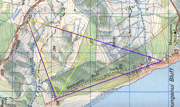
We'll start off by assessing the Khafre Pyramid 3,4,5 triangle geometry first, as it extends between markers on all 4 sites and sets up a template for creating additional geometry of the Great Pyramid and Menkaure Pyramid of the Giza Plateau. In antiquity the pyramid geometric encoding system was designed from the Waitapu Valley's northern ridge and a pillar marker was erected there to establish a pivotal centre for the tri-pyramid geometry.
Figure 6: The geometry shown in this picture is based upon GPS fixes on ancient structures such as cairns, standing stones, tor mounds or sighting pits. These coordinate positions were later translated from World Geodetic System 1984 configuration to New Zealand Map Grid configuration. The NZMG coordinates were then introduced into AutoCAD to provide precise distance and angle information related to the positions of ancient structures.
Initial conclusions related to just how these Khafre related triangles were designed to sit on the landscape concentrated on the angle of the "opposite" running up the coastline. As it turns out the deciding factor was the azimuth angle of the hypotenuse in each case. These determining hypotenuse codes, for correct orientation of each 2-dimensional pyramid design, will be explained as we proceed.
The blue
3,4,5 triangle runs for 9450 feet from the Benchmark Cleft at an azimuth angle
of 339.73-degrees to within 24 feet of a sighting pit at the southern end of the
summit of the modified and steep coastal hill SSW of Puketapu Observatory. The
summit plateau is only 65 feet long and less than 15 feet wide. The resolving
position sits on the gentle southern slope of the summit.
At this point the
line turns 90-degrees and runs for 7087.5 feet to the Kerr Road Observatory plateau
at an azimuth angle of 70.14-degrees. At Kerr Road Observatory the corner position
falls 42 feet short of a large boulder marker, but amidst peripheral marker stones
associated with it. The return line, running for 11812.5 feet back to the Benchmark
Cleft, is at an azimuth angle of 197.01-degrees. This means that the hypotenuse
angle running from the Benchmark Cleft to the pyramid corner on Kerr Road lies
at 17.01-degrees azimuth.
The return degree angle is the key to knowing
how to orientate the 2-dimensional representation overland, as the number 1701
is one of the primary lunar codes of antiquity. There were 4 periods of 1701-days
in the 6804-day lunar nutation cycle. Indeed, the angle from the Benchmark Cleft
up the sea cliff coastline to the resolving position at a sighting pit of the
seaward tor hill was 340.14-degrees. This would have been symbolically read as
340.2-degrees (1/2 of 680.4) and relate once again to the lunar nutation cycle.
This 3,4,5 triangle was a replica of half the Khafre Pyramid X 20. Khafre was Egypt's pyramid of the moon and contained all of the lunar coding, as well as the principle of 3,4,5 triangulation, used in building work since time immemorial.
A full, two-dimensional Khafre Pyramid replica at X 10 scale was also built into this template (yellow). The apex point for the smaller scale pyramid was the large boulder pillar marker on the northern ridge of the Waitapu Valley. From the marker one side of the pyramid ran for 5906.25 feet to the assembly area plateau of the coastal hill at an azimuth angle of 303.27-degrees. It then turned and ran for 7087.5 feet to resolve onto a double sighting pit with a central hump at Kerr Road Observatory.The azimuth angle to this position from the ridge pillar (5906.25 feet distant SSW) was, again, 17.01-degrees.
THE GREAT PYRAMID GEOMETRY.
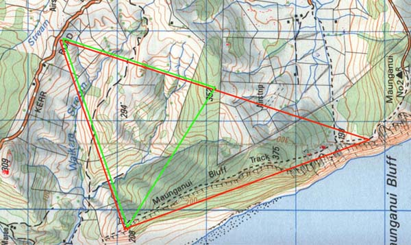
Figure 7: The red triangle is a replica of half the Great Pyramid X 20. It's not quite a 3,4,5 triangle as the Great Pyramid has a slope angle of 51.84-degrees (1.290-degrees less than Khafre). The line running up the coast proceeds for 9620.86 feet from the Benchmark cleft, at 339.98-degrees azimuth, to the eastern end of a flat cut shadow cleft terrace 63 feet beyond the summit, on the northern slope of the steep coastal hill. From there the line turns 90-degrees and runs for 7560 feet, brushing an important large boulder marker within the Kerr Rd Observatory complex. Although the corner end marker position has not as yet been recorded, the return line back to the Benchmark Cleft exactly dissects the stand of large obelisks that constitute the site's most important position. The lack of the corner marker is due to the position of Kerr Road itself, as the marker would reside up on the ridge line where the road is situated and seems to have been eradicated during road construction. The fact that Kerr Road Observatory's most important markers are dissected by incoming and outgoing lines lends credence to the corner marker having resided at the theorised position.
The length of the hypotenuse
line to the Benchmark Cleft is 12235.79 feet, consistent with 20 X 611.7894615
feet (the calculable length up the side of the Great Pyramid if it had a capstone
(which it never did). The azimuth angle of this return line was 198.144-degrees.
This means the azimuth angle from the Benchmark Cleft to the pyramid corner at
Kerr Road was designed to be 18.144-degrees. The length of the Great Pyramid's
base was 756 feet or 9072 inches and 2 X 9072 = 18144. Again, it's the hypotenuse
angle that codes the orientation of this giant overland triangle. The distance
of 18144 feet would be 1/7200th of the circumference of the Earth under the ancient
Egyptian sexagesimal geodetic system. A distance of 18.144 inches would be 1/500th
of the base length of the Great Pyramid.
The green triangle is a two-dimensional representation of the Great Pyramid X 10 in scale. Again the apex of the pyramid is tied to the northern Waitapu Valley ridge pillar. The line to the steep coastal hill runs for 6117.9 feet at an azimuth angle of 301.82-degrees and resolves nicely upon the small centre summit plateau. From there the line turns and runs for 7560 feet to the Kerr Road Observatory. The corner marker has not been recorded, as it was undoubtedly eradicated when Kerr Road was built. The return line from the corner runs back through an impressive boulder cairn marker and brushes another sighting pit with a boulder marker on its western edge.
THE MENKAURE PYRAMID GEOMETRY.
The Menkaure Pyramid, with a base length of 356.4
feet, is less than half the size of the Great Pyramid and marginally more than
half the size of Khafre. Like the Great Pyramid it was designed to have a face
angle of 51.84-degrees.
In order to fix its codes into the New Zealand landscape,
the ancient surveyors had to scale it to 40 X its actual size. This is how it
looks in the Waitapu Valley region.
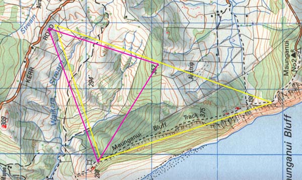
Figure 8: It would appear that the line running from the Benchmark Cleft was designed to be 341.04-degrees. The line (yellow) reaches the southern face of a tor mound on the ridge. The coastal line is 9072 feet or 4536 feet X 2. The Great Pyramid was 9072 inches long and 453.6 feet high to the top of its flat altar floor. In this very important height are the codes for remembering the equatorial size of the Earth under a sexagesimal geodetic system. The line turns 90-degrees and runs for 7128 feet to resolve in the near vicinity of several recorded markers. It appears we'll have to return to the Kerr Road site to record more of the markers there, as a definite corner position for this geometry has not yet been verified. This orientation seems to be the likeliest as the azimuth angle from the Benchmark Cleft is 19.2-degrees...a much used ancient number. The distance to the Benchmark Cleft, under this theorised coding, was 11536.60 feet at 199.2-degrees azimuth.
The above orientation of the giant triangle appears to be the likeliest, although there were several other subtle possibilities.
As far as the smaller version
Menkaure representation is concerned (purple) it's a perfect fit on all points.
From the ridge pillar of the northern Waitapu Valley the line extends for 5768.3
feet to fall on a boulder cairn north of the coastal hill's tor mound. The azimuth
angle of this line is very positively coded at 301.5-degrees to provide a return
angle of 121.5-degrees. This number is a major lunar code that was much used for
tracking the progress of the moon during the 6804-day lunar nutation cycle. The
distance of 12150 feet also extends, in another coded instance, from the Benchmark
Cleft to the crown boulder cairn on the summit of a hill at the intersection of
Hood and Kerr Roads.
From the coastal hill the Menkaure line runs for 7128
feet and resolves exactly upon the main obelisk position of the Kerr Road site.
It then turns and runs back to the pillar on the ridge at an azimuth angle of
197.82-degrees.
The absolute validity of this pyramid's coding into the landscape is attested to in the return angle from the ridge pillar to the Kerr Road, central obelisk position. That return angle is 17.82-degrees…half the base length of the Menkaure Pyramid is 178.2 feet and this was also the "whole/ non-PHI" code carried within the "Y" Holes circle diameter at Stonehenge.
There can be no question about the inclusion of this particular, two-dimensional, Menkaure representation, as at all points the triangle is positively marked to produce the pyramid configuration at 20 X true scale.
It's obviously no coincidence that 4 isolated sites, complete with their own compact array of purpose built structures and separated by a considerable distance (over 2-miles between hypotenuse markers), happen to be situated so conveniently in relation to each other. The increased scale, two-dimensional pyramid geometry for the 3 Giza pyramids could most certainly be demonstrated by using all 4 sites combined. If the ancient people weren't using the sites in this manner, THEN THEY BLOODY-WELL SHOULD HAVE BEEN...because that's what the sites are perfectly set up to do.
Figure 9: This is how the seaward cliff line geometry for the 3-pyramids works out, as it resolves upon the much modified hill about 1.8 miles north of the Benchmark Cleft. The red lines relate to Great Pyramid geometry and these resolve to positions just beyond the summit or right onto the small summit itself. The blue lines relate to Khafre Pyramid geometry and they resolve to the southern side of the summit position or east of it on an assembly plateau. The yellow lines relate to Menkaure geometry and they resolve to a marker just north of a double hump, ridge tor mound or onto the southern inclined face of the tor mound itself. The distance between the most northerly resolving position (Great Pyramid) and the most southerly (Menkaure) is 578 feet. Each small blue circle shown represents the centre of a purpose built structure. These relationships are far too good to have happened by chance!
To determine the resolving corner positions of the pyramid geometry, angle and distance calculations would have been carried out from the central ridge pillar some 6100 feet SE of the sea cliff hill's summit. There are many varied type markers on the sea cliff hill, each one relating to coded distance or angles when used in conjunction with other associated, distant overland markers. Very good relative accuracy in the placement of markers could nave been achieved by use of manual surveying instruments.
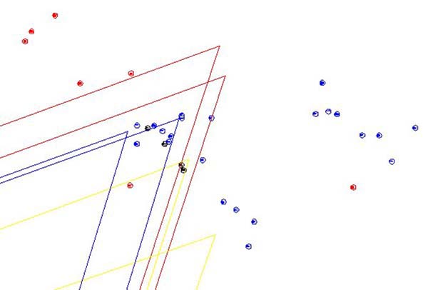
Figure 10: This is the way the corner positions of the pyramid geometry would relate to structures on the Kerr Road Observatory site. The red lines are Great Pyramid geometry and these corner positions would have been eradicated in the construction of Kerr Road. The blue lines relate to the Khafre Pyramid geometry, giving good relationships to positions surveyed. The yellow lines relate to Menkaure Pyramid geometry, providing a solid hit onto the Kerr Road central obelisk position and another yet to be verified, which is close to surveyed structures.
So, let the reader be the judge. These sites have lain in ruination for a very long time and haven't been in use for centuries, but are still more or less intact. Remember, this geometry is in an exact scale to each of the 3 Giza Plateau Pyramids of Egypt. Anyone who chooses to do so can go to the Waitapu Valley region and view the structures, take GPS fixes on their positions and duplicate the analysis written about herein.
If you'd like to view the many structures, farmer Michael Griffith has "homestay" farm houses available to provide accommodation for researchers. Call Michael & Linda at : (09) 4390667 or email at: pendre@ihug.co.nz to see tor mounds, standing stone circle observatories, sighting pits, cairn heap markers, forest and field obelisks, a cut cliff benchmark cleft feature, trig boulders and much neglected, muted New Zealand history. This website will shortly provide coordinate fixes on where items are found, such that researchers can conduct their own GPS tours to locate the ancient structures.
Overseas researchers are encouraged to come and visit our ancient New Zealand megalithic sites...but if you call Michael, please remember our time zone...he's a dairy farmer and gets precious little sleep as it is.
ADDITIONAL PYRAMID CODING.
There are yet other clearly marked geometric representations of the Great Pyramid in the Waitapu Valley and several additional lengths and angles that relate to the pyramid. Let's look at some of these.
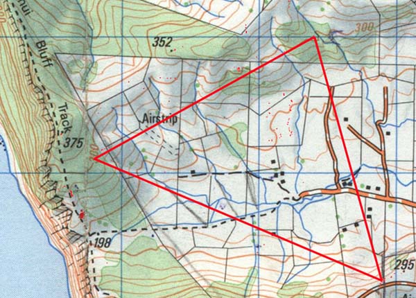
Figure 9: This depiction of the Great Pyramid is at 10 X scale once again and
hits very positively onto markers within the Waitapu Valley. A giant obelisk discovered
near the Bushline Observatory in September 2002 marks the corner of the pyramid
to the western sector. From there the pyramid baseline extends for 7560 feet to
the centre of the tor mound on the southern ridge of Maunganui Bluff where it
resolves upon a boulder marker. The line then turns and runs for 6117 feet to
a peninsula tor mound on the northern side of the valley before returning to the
obelisk.
Digger operator/ surveyor, Ian Pyke in company with dairy
farmer, Michael Griffith, first discovered the impressive peninsula tor structure
in April 2002. As an experienced earth moving contractor, Ian has a trained eye
for detecting unnatural earth-mound formations or other types of ancient, surveying
related structures on the landscape. He has been instrumental in locating many
cairn, tor mound or sighting pit surveying markers around the valley and outlying
districts.
To add yet more credence to the fact that the above, exact pyramid
geometry is definitely encoded into the Waitapu Valley one can consider the azimuth
angle that the left face diagonal lies on. There are two ways to calculate the
coded length of the Great Pyramid's side. One is the face diagonal length based
upon an angle of 51.84-degrees, giving a length of 611.7894615 feet. The other
method is to simply multiply half the base length (378 feet) by PHI (1.6180339)
to get 611.6168142 feet (a shortfall difference of about 2 inches).
In the
above picture the azimuth angle up the left face side sits at 61.16-degrees east
of true north. It will be remembered that Menkaure Pyramid geometry mentioned
earlier was set to an azimuth angle of 17.82-degrees when half the base length
of Menkaure was intended by its architects to convey 178.2 feet. In the methodology
of the early surveyors both a length and angle would carry a code where possible.
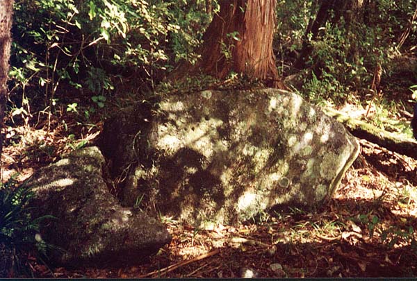
Figure 10: The large, broken obelisk stone, dappled in shadow and lying in front of the platform upon which it once stood. A rimu tree now grows out of the former pedestal platform. This giant stone, which would once have stood in excess of 6 feet tall when housed into the ground, was located by Stacey Pyke and Sid while they were doing a forest sweep looking for ancient, purpose erected markers near the Bushline Observatory. Several boulder cairn and obelisk positions were found during the search and, thankfully, the forest canopy was thin enough to allow GPS fixes to be taken. Careful AutoCAD analysis is slowly revealing the design purpose behind the placement of each marker. This obelisk sits on an equivalent level to the southern ridge tor mound and the peninsula tor of the northern side of the valley…the 3 station points of Great Pyramid geometry encoded within the confines of the Waitapu Valley.
YET MORE PYRAMID CODES.
Throughout the Waitapu Valley there are several lengths and angles that are suggestive of Great Pyramid geometry being encoded. Here are some samples of this occurrence.
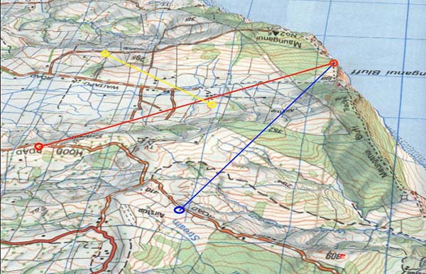
Figure 11: The blue line runs accurately for 12235 feet from the Benchmark
Cleft to a boulder cairn on the hill above the Kerr Road Observatory site. This
distance is the length up the side of the Great Pyramid (including symbolic apex)
X 20. The line proceeds from the Benchmark Cleft at an azimuth angle of 20.16-degrees.
Calculations undertaken to see how the top altar section of the Great Pyramid
carried codes indicated that one square of 44 feet (extremity limits of the floor)
and another of 42 feet (1 foot border all around) were primarily important. The
4-side inch total of a square 42 feet per side is 2016 and this number features
prominently in ancient navigation.
The red line runs from the benchmark Cleft
to the main northern ridge tor mound plateau sighting pit at an azimuth angle
of 51.84-degrees, which was the intended design slope angle of the Great and Menkaure
Pyramids. The distance to the western face approach of the tor mound would comply
very favorably to 12235 feet. Unfortunately, some minor quarrying near that side
of the tor mound (about 20-years ago) has eradicated traces of any former markers
situated there.
The yellow line runs for 6117 feet (the Great Pyramid's face
diagonal length if it had a capstone X 10) from a boulder cairn near the Telecom
Road to the apex of a modified, inner valley hill dotted with boulder markers.
The azimuth angle of this alignment is 308.16-degrees, which is 360-degrees minus
51.84-degrees (the pyramid's slope angle).
The positive recurrence of vivid pyramid geometry, based upon the dimensions and angles of Giza Plateau pyramids helps to refine our knowledge of who New Zealand's ancient core population was.
Ancient New Zealanders left clear-cut expressions of their measurement
standard, astronomical, calendar and navigational numbers, sexagesimal degree
angle system, etc., consistent with what was left throughout Great Britain, Continental
Europe and the Mediterranean Basin.
This ancient stock of cousin peoples
were highly migratory and general structural styles (domestic and scientific),
found upon the New Zealand landscape, look more like those of Megalithic Great
Britain and France than any other single location. From this it can be surmised
that ancient people of Western Europe were the most successfully established and
widespread population to colonise New Zealand in the BC era.
Branches of the
Mediterranean/ European family tree settled en mass in the Americas in remote
antiquity, with latter offshoot branches joining long lost cousins at the base
of the South Pacific.
If we were permitted to do DNA sampling on the tall
red headed skeletons that repose in ancient burial caves or sand dunes around
New Zealand (often in a trussed or sitting position) then lingering questions
of just who the early occupants were would be quickly answered.
As long as
the authorities continue to deny scientists access to those suppressed DNA samples,
we can do no more than mathematically assess the residual structures that dot
New Zealand's very ancient landscape.

October 9th 2002.