SOME CODES RELATED TO PUKETAPU HILL OBSERVATORY.
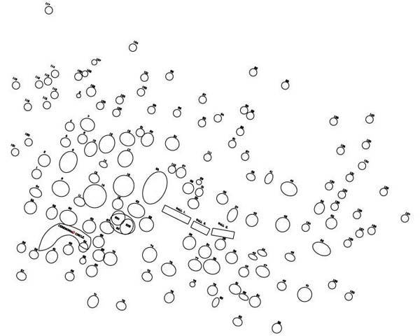
Figure 9: At a distance of 3 miles north of the Waitapu Valley southern ridge
tor mound is Puketapu Observatory, which is made up of about 200 cairn marker
positions. The site was partially surveyed in early 1997 by members of the Cook-Claire-Doutré
families, with the foregoing result. Although further careful work must be undertaken
before this site can be fully or realistically assessed, with all components
included, it can be said with a certain confidence that the cairn positions
will code particular significant angles and distances.
We'll now concentrate on coded lengths and angles that run to Puketapu Hill from far distant locations, such as the Waitapu Observatory and tor mounds on the northern and southern Waitapu Valley ridges.
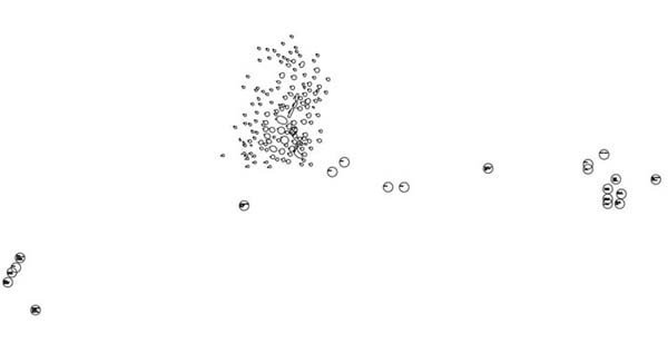
Figure 10: The Puketapu Observatory showing its cairns in scale size. Other circles simply indicate where cairn markers sit and are oversized so that they can be visually detected in the huge dimension, AutoCAD representation. The centres of the circles indicate the position where each cairn or boulder marker sits. To the left of the observatory picture are circles indicating the position of a huge hubstone boulder and a series of outlying cairns. These are by no means the sole markers on that site. To the right of the observatory are the cairn positions residing on the summit of Puketapu hill and its slightly lower southern saddle. Many unregistered cairn positions lie on the southern slopes.
Let's now assess some dynamic geometry, which extends over a great distance to and from the structures of Puketapu Hill.
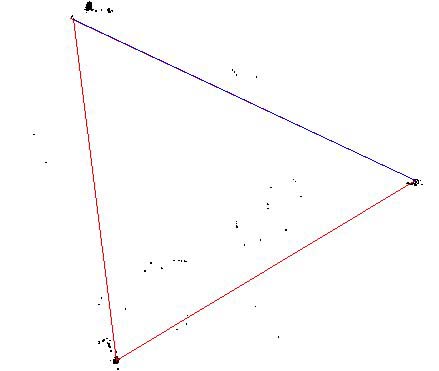
Figure 11: The ancient feat of surveying, related to this triangle, is quite astounding and the overall result displays a degree of error of only about 17 feet in over two miles where lines converge on the wrecked, lower, overland mapping and alignment site associated with Puketapu Hill. New Zealand based researchers are encouraged to take very careful note of the following:
1. The distance from the huge hubstone on Puketapu Hill's lower overland alignment site to the southern hubstone of the Waitapu Observatory is 11340 feet at an azimuth angle of 172.8-degrees. The 11340 feet distance is a very prominent lunar code. It is the exact distance equivalent of 15 sides of the Great Pyramid or 16 sides of the Khafre Pyramid, on the Giza Plateau of Egypt. The 11340 distance is in mnemonic reference to a day count interval within the 6804-day lunar nutation cycle (major standstill to major standstill) wherein 1134-days equals 1/6th of that period.
The width of the Station Stones Rectangle at Stonehenge is 113.4 feet. Three side values of the Great Pyramid are 2268 feet or 1134 feet X 2. Remember, there has already been another occurrence of this same length within the Waitapu Valley (from the northern ridge tor mound to the cairn adjacent to the DOC archaeological post marker above the Waitapu Observatory).
The 172.8-degrees azimuth angle codes one of the most important navigational numbers of antiquity. The Great Pyramid is 1728 Royal Hebrew/ Celtic Cubits (21 inches) in its perimeter value. A circle encompassing the "Crosshouse of Miringa Te Kakara" at Bennydale, NZ was 172.8 feet in circumference. Silbury Hill in Southern England has a diameter of 550 feet and a circumference of 1728 feet.
This principle of an "11" series linear distance (550 feet) converting to a "6" series circumference (1728….360 X 4.8) was the basis of ancient world navigation and angle plotting on charts to keep track of "point of departure" and "destination" despite course changes. All linear distances were plotted in "11" series numbers like fathoms (5.5 feet) furlongs (660 feet) or leagues (16500 feet… 1500 X 11).
2. The distance from the southern hubstone of the Waitapu Observatory to the tor mound on the northern ridge adjacent to Hood Rd is 11520 feet at an azimuth angle of 59.0625-degrees. The 11520 distance is .8 of a Geomancer's mile from Britain. The face value of the Great Pyramid is 230400 square feet (115200 X 2). The 11.52 number (or increases thereof) was used in many functions within the ancient parcel of sacred number applications.
The 59.0625-degree azimuth angle is a dynamic lunar code from the Khafre Pyramid where, under a 3.4.5 triangulation or squaring principle, the hypotenuse (diagonal face from base to apex) was 590.625 feet. Half of the Waitapu Valley degree angle is 29.53125-degrees and this also happens to be the number of days in a lunar month to an accuracy of 57 seconds.
3. The distance from the northern ridge tor mound to the huge hubstone of Puketapu Hill's lower plateau alignment site is 12500 feet or 6000 increments of a large cubit rod located in Egypt, which was 25 inches in length. The azimuth angle of this line is 295.3125-degrees, again accentuating the 29.53125-days in the lunar month.
4. At a distance of 100 feet further NW of Puketapu's huge, lower plateau hubstone are a series of cairn positions in a line near a farm fence. From the SSW most cairn a line runs back for 12600 feet to the front face position of the northern ridge tor mound adjacent to Hood Road at an azimuth angle of 115.2-degrees. This distance is exactly 1200 reeds of 10.5 feet each. The Great Pyramid, @ 3024 feet, is exactly 288 reeds in perimeter value.
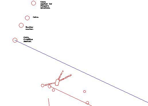
Figure 12: This is the triangle intersection at Puketapu's lower site showing
the site layout as it actually appears. The red line running up from the southern
hubstone of the Waitapu standing stone observatory (for over 2.1 miles) stops
17 feet short of the red line running from the northern ridge tor mound. This
small degree of drift shown is the only discernable error in the entire triangle
and might not be an error at all, as any "shortfalls" are amidst a
series of standing stone markers and cut terraces to the south of the huge hubstone.
Inasmuch as the triangle here shown was configured to specific side lengths
and precise angles within the exacting confines of AutoCAD (based upon satellite
GPS fixes taken on existing archaeological structures), no greater geometric
perfection is possible for a triangle of those precise dimensions. The ancient
mathematicians obviously knew that this specialised triangle would have 1 shortfall
intersection, but saw a wonderful opportunity to encode 3 numerically perfect
side lengths and 3 perfectly coded degree angles simultaneously.
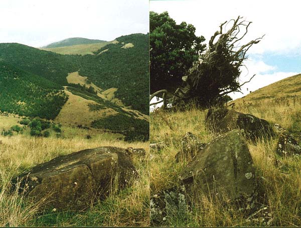
Figure 13: The left photo shows the huge "tipped-over" hubstone, with the summit of Maunganui Bluff looming up in the far background. The highest mountain peak to the north at Pungaru is exactly 180-degrees opposed to this view and the huge hubstone sits in a perfect interim position between the summit of Maunganui Bluff & the northern mountain. A cairn sitting 100 feet out from the hubstone clearly marks that northern alignment. The second photo shows the huge hubstone in the background, surrounded by a set of individual marker stones, some of which are still in their upright, original positions. A large Puriri tree in the background has been blown over, but is still healthy and surviving quite well.
Our modern-day "Waitapu to Puketapu" overland survey was based solely
on "satellite navigational fixes" using a good quality GPS unit. All
coordinate fixes taken were later run through LINZ (Land Information
New Zealand) where a conversion facility rendered everything in NZMG (New
Zealand Mapping Grid) configuration. The LINZ converted coordinates were then
placed directly into the clinically precise environment of AutoCAD, which produced
these finalised, fully computer-generated results.
It must also be noted that the 3 intersections of this giant triangle were largely invisible to each other, except the view from the southern hubstone of the Waitapu Valley to the north ridge tor mound. That sighting, at least, got onto the plateau where the tor sat, although the tor's actual position was partially obscured by the declining end of a nearer hill. The view from the tor to Puketapu's lower plateau was fully obscured by an interim hill, as was the view from Puketapu toward the Waitapu Observatory. Each of these meticulously surveyed, triangle intersection positions would have been determined by lines of sight from a series of secondary markers. The accomplishment in creating this dynamic triangle represents superb ancient surveying ability, using simple, manual equipment.
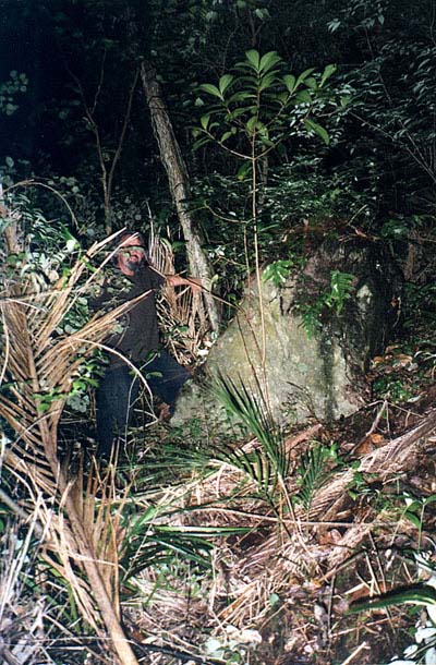 |
Some large, standing Obelisk/ Menhir positions within the
deep forest of Maunganui Bluff's north facing slope are very difficult to
get a satellite fix on because of the density of the forest canopy. These
giant upright boulders, some protruding 8 feet above ground level, have
obviously been purpose placed.
Had they rolled to their positions from some unknown rock cascade source
further up, then they should be lying on their sides rather than standing
erect. |
At the outset of this series of articles, I mentioned the 3-years or so of
utter indifference that New Zealand's academic community has displayed toward
the structures of the Waitapu Valley. Ultimately, the purpose of this exercise
has been to show, in the clearest possible way, what's on our New Zealand landscape.
The conclusions drawn are not meant to be definitive or final in every case
and are offered in lieu of a deeper scientific investigation using state of
the art equipment. This researcher remains confident, however, that the preliminary
conclusions drawn will stand up to rigorous scientific scrutiny.
To be continued.

9th of July 2002.