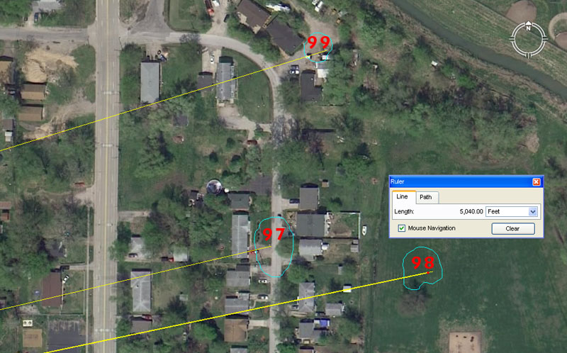
Mounds 97, 98 & 99 are situated in East Collinsville.
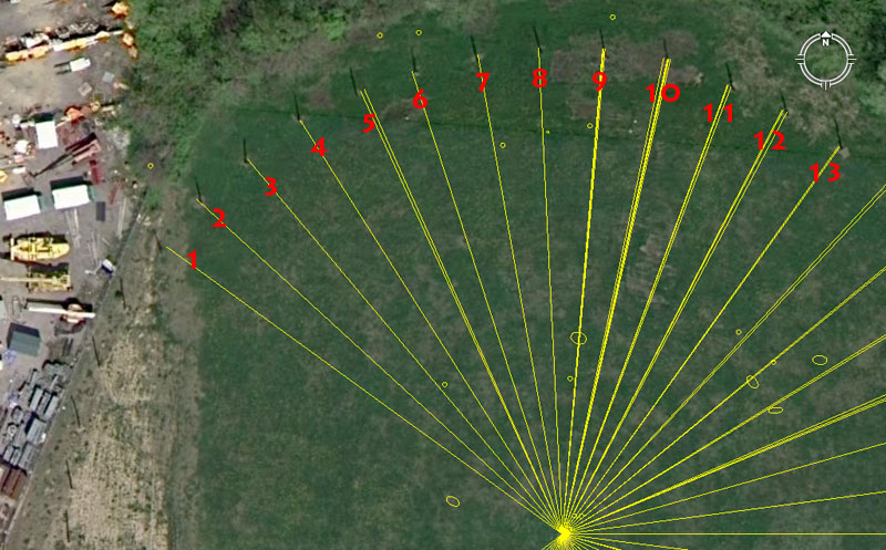
Mound 97 sits 4752' out from the hub position atop Monk's Mound at an azimuth angle of 76.8-degrees.
The sum of 47520' would equate to 9-miles of 5280', therefore this distance at Cahokia mounds complex is .9 of a mile.
The azimuth angle is navigational coding and part of the 11.52 mathematical progression. The sum of 76.8-miles would be 1/324th of the 24883.2-mile equatorial circumference.
Mound 98 sits 5040' from the Monk's Mound hub @ 78.125-degrees. The sum of 5040' is 50 seconds of equatorial arc @ 100.8' per second.
The azimuth angle value, used in a mathematical progression, generates many values useful to navigation and, essentially, divides base ten values into 32nd, 64th and 128th parts, etc. Therefore, 10000 ÷ 128 = 78.125.
Mound 99 sits 4950' from Monk's Mound hub @ 72.9-degrees. The 4950 value is an important within the "11" navigational system and 495 miles would equate to 1/16th of the 7920-mile diameter of the Earth. At the same time, 4950-miles would equate to 1/5th of the 24750-mile equatorial circumference.
The azimuth angle is both navigational and lunar coding simultaneously and 729' would equate to 750 Roman feet or 150 Roman paces. There would be 35 intervals of 72.9-days in the 2551.5-day period (7.2 lunar years) monitored within the lunisolar Sabbatical calendar.
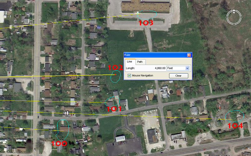
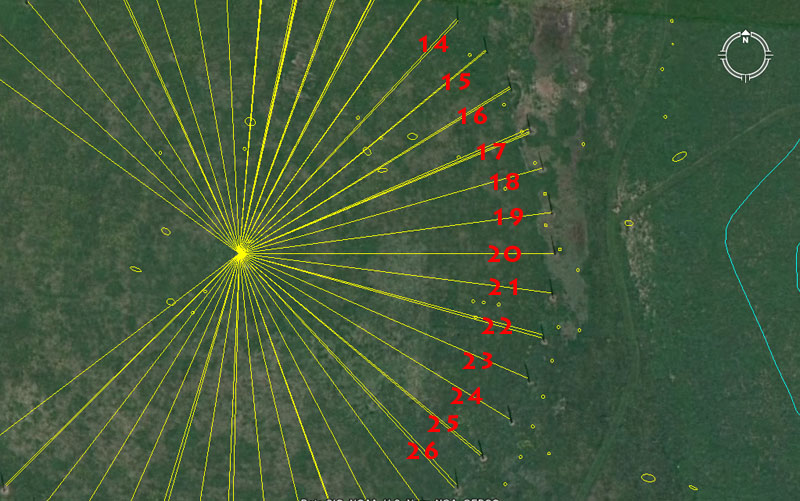
Mounds 100, 101, 102, 103 &104 complete the list of known or recorded mounds within the Cahokia complex. There are estimated to have been up to 120 mounds originally, but Melvin Fowler's list stops at 104.
Mound 100 sits 4500' from the Monk's Mound hub @ 93.75-degrees. In the 360-degree compass the division of 45-degrees represents 1/8th part. This same mound would have carried a tutorial concerning the merits of 4536', which is strong navigational coding found on the Great Pyramid. The length of the Great Pyramid in inches is 9072" or 4536 X 2. The vertical height of the pyramid (to the top of its altar floor) was measured by Petrie to be very close to 453.6' and in all recorded history the edifice has never been known to have a pointed top or capstone.
The degree angle is navigational coding and a mathematical progression based upon 93.75 generates both compass values and divisions related to the 24750-mile equatorial circumference. The sum of 93.75-miles would equate to 1/264th of the 24750-mile circumference (264 X 20 = 5280).
Mound 101 sits 4800' from Monk's Mound hub @ 91.125-degrees. The value 48, when used in a mathematical progression, generates very important navigational values and the sum of 480' is 1/11th of a mile.
The 91.125-degree return angle is primarily lunar coding and there would be 28 intervals of 91.125-days (911/8th) in the 2551.5-day (7.2 lunar years) monitored within the ancient lunisolar calendar. This same angle coding was used for mound 90.
Mound 102 sits 4860' from Monk's Mound hub @ 268.8-degrees. This distance is 1 Roman mile. The value 486 provides powerful lunar and navigational numbers when placed into a mathematical progression. The sum of 48.6-miles would be 1/512nd of the 24883.2-mile equatorial circumference, which is, essentially, equivalent to dividing up the Earth by 2, 4, 8, 16, 32, 64, 128, 256, 512.
Likewise, the sum of 486-days would equate to 1/14th of the 6804-day lunar nutation cycle. The summer solstice sunrise at Stonehenge occurs at 48.6-degrees azimuth (first glint). The ancient Calendar of Coligny brass plaque (Druidic lunisolar Sabbatical calendar) is 4.86' long or 58.32" (1 Roman pace or 5 Roman feet of 11.664" each), etc., etc.
The 268.8-degrees return azimuth angle was very deliberately incorporated into this mound to, again, accentuate the value 486. The 24883.2 Greek mile equatorial circumference equates to 130636800' and 1/2688th of that circumference is 48600' or 10 Roman miles.
Mound 103 sits 5062.5' from Monk's Mound hub @ 84-degrees or 264-degrees return angle. The 5062.5' distance is, primarily, lunar coding and 50.625-days would be 1/7th of a lunar year of 354.375-days.
The value 84 (2 X 42) generates very important values in a mathematical progression that relate to the 24883.2 Greek mile equatorial circumference and 84' is 1/72nd of 1-minute of equatorial arc.
The return angle @ 264-degrees is coding in homage to the 5280' mile (2640' X 2).
Mound 104 sits 5670' from Monk's Mound hub @ 92.16-degrees or 272.16-degrees return angle. The distance is lunar coding and there would be 12 intervals of 567-days in the 6804-day lunar nutation cycle.
The 92.16-degrees angle to mound 104 is strong navigational coding and the sum of 92.16-miles would be 1/270th of the 24883.2-mile equatorial circumference.
The return angle @ 272.16-degrees is both navigational and lunar coding and the 130636800' equatorial circumference (24883.2 Greek miles) ÷ 27216 = 4800' (remember mound 101 sits out 4800' from the Monk's Mound hub).
AND SO THE REASON FOR BUILDING THE HUGE COMPLEX BECOMES CLEAR.
One of the baffling questions that plagued the minds of generations of spectators is, why would anyone go to this much trouble to build huge mound complexes? To date, none of the reasons proffered by our archaeologist or historians are even marginally adequate to explain this degree of commitment. In reality, any egomaniac leader of old, who simply wanted mounds as status symbols (as has been suggested by our experts) would soon get the "short-sharp-shift" from the minions. There's no way that individuals within a society would commit themselves to a lifetime of digging and hauling dirt, then curse their children and children's children to the same plight, unless there was a very sound reason for doing so.
With regards to the Cahokia mounds complex, which also included yet another large and mathematically linked complex across the Mississippi River in what is now Old St. Louis, Missouri, it's evident that the confederation of architects and builders entered into the project willingly and participated without reservation to see the work brought to a successful conclusion. The impetus to do so was a knowledge that they were encoding into the mounds all of the numbers of civilisation, such that the hard-won scientific knowledge could never be lost. As long as the mounds stood there as sentinels of the knowledge, generations of gifted children could be educated to become walking repositories of the ages-old sciences, and society could continue to be blessed with abundance accordingly.
Much of what is encoded into the mound positions relates to positional-plotting (dead-reckoning) methods for safe traversals of the world's oceans. It's very evident that many Bronze Age ships made the crossing from the Orkney and Shetland Islands, via Iceland and Greenland to the North America to mine copper. It's estimated that as much as 500,000 tons of copper were removed at places like Isle Royale and all of it left American shores for places unknown. Thousand of ancient mines still exist on the Canadian North Shore of Lake Superior, Isle Royale and the Keweenaw Peninsula of Michigan, where copper that was 99% pure could be extracted and shipped without refinement. By consequence, the copper ore of the Mediterranean needed considerable refinement, which led to the denuding of whole countries of their forests to get the required firewood to feed the furnaces. See: http://www.philipcoppens.com/copper.html
ELEMENTARY SCHOOL.
What was happening at the Cahokia Mound's complex is exactly the same thing as was happening at Avebury Henge and Durrington Wall's Henge in Southern England or at Brodgar Ring in the Orkney Island ... same methodology ... same numbers ... same everything. At each of these sites, student navigators were instructed by learned tutors or "Masters of the Craft". The evidence shows that at grueling, hard schools like Brodgar Ring, the students were assigned quests to navigate out and about amongst the mounds, even to the extent of crossing bodies of water to mounds on outlying islands, then find their way home again. This was all excellent practice for following the distances and angles marked on sea charts that would later lead the qualified navigators across featureless oceans to other countries or islands. In essence, the Cahokia Mounds complex represented exactly that, artificial islands of land sporadically dotting a vast flat plain that symbolically represented the sea. Groups of students could be given a particular course to follow, marked only by distances and angles and then be required to find their way around the maze on their assigned quest. They had to stay constantly aware of the position of true North and from that calculate both the degree angle and distance to the objective.
But abilities had to be developed from raw to refined over time and competence gained by constant practice to hone navigational skills, until it all became second nature. Underlying everything was a knowledge of special, factorable numbers and these had to be memorised before there was any hope of fulfilling specific navigational assignments in & out & around the mounds . The basic parcel of astronomical-navigational numbers were first taught to the students at smaller sites, such as Woodhenge beside Durrington Walls Henge in Southern England ... or Woodhenge near Monk's Mound in Illinois, North America. It's altogether possible that bright children, who had been recognised as gifted when still toddlers, were set aside for the purpose of learning the numbers and began doing so from a very young age, such that they were utterly conversant with the numbers as they entered adolescence.
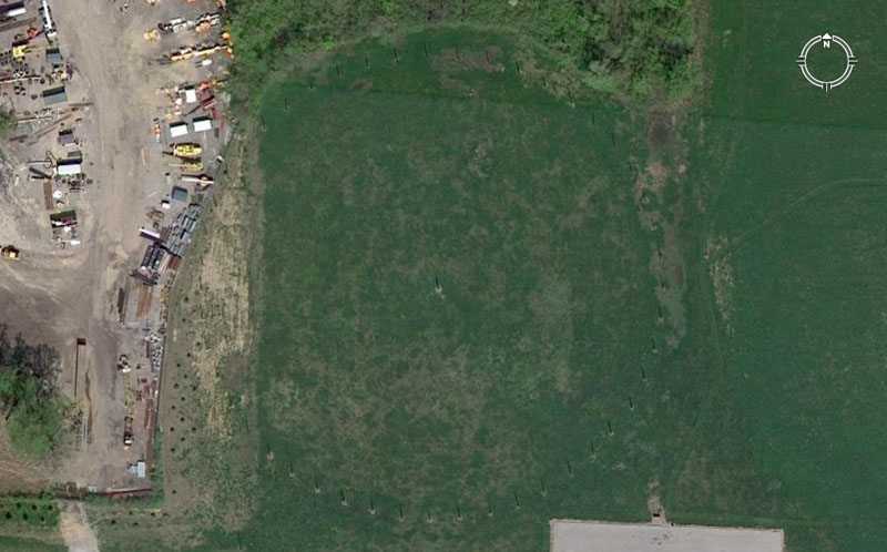
The main circle of posts at Woodhenge, Cahokia Mounds complex, are clearly seen in the above image. A discoloured scour or scar in the ground is seen to the left and this is where soil was appropriated for roading before it was realised that a post circle had existed at this position. Sadly, about 9 positions of former posts were obliterated permanently. However, another 39 positions on this ring are preserved and newly erected posts are in the ancient holes once again. Yet another Woodhenge site sat SSW of Monk's Mound adjacent to Mound 72.
Our archaeologists have found other post holes in and around this site and have formulated a questionable notion that the ancient astronomers changed their minds a few times and moved the circle sideways every so often. This dubious hypothesis of an original circle, followed by 4 replacement circles, is based upon additional fans or arcs of former posts. It's highly likely that these secondary arcs of posts simply provided extra distance & angle codes over and above what was available on the main circle. The on-site evidence suggests that the ancient astronomers weren't the least bit fickle or indecisive about their preliminary choice and set out all the posts in exactly the right spots the first time, then left them there, only replacing rotten posts periodically by putting new wood into old holes. Let's extract the surviving codes from the main ring seen above. To do this we'll use our own numbering system.
Remember, all decimal tails seen tagged onto the ends of whole numbers are SIMPLE FRACTIONS, perfectly within the capabilities of ancient mathematicians to calculate and work fluidly with in mathematical progressions. This covers all numbers used by the ancient astronomer-navigator-surveyors, with the exception of the pure PI & PHI ratios.
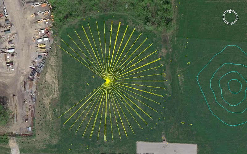
The centre post of Woodhenge sits 3652.5' from the hub position atop Monk's Mound at a return angle of 88-degrees. The distance relates to the 365.25-days in a solar year and the angle is navigational coding, within the 24750-mile equatorial circumference. The sum of 88' is 1/60th of the 5280' mile. Many small dots are seen within and outside the Woodhenge site and these are spots where other posts or markers have been found, leading to the improbable theory of 5 overlaying circles.
It's important to realise that a post represented a prop for teaching several close proximity values simultaneously. The Masters of the Craft would not let any teaching opportunity bypass them and everything that could be extracted from a position would be exploited ... which means that, not only a coded vector falling upon the centre of the post, but others falling to each side would be elucidated upon at length. An example of this is shown below in the position of post 5, where the actual code of the post relates to an outwards distance of 206.25' (navigation by the "11" system) and a return angle of 155.52-degrees (equatorial circumference of the 24883.2-mile Earth). However, another tutorial could include the slightly offset, close proximity, outrunning angle of 336-degrees (navigation).
What's seen here at the Cahokia Mounds Woodhenge is a modus operandi of teaching the numbers on a micro site, before the students moved to a macro site (the mounds complex). This same modus operandi is duplicated at Woodhenge in Southern England.
1. 207.36' (Egyptian Royal Cubit devoted to the 24883.2 mile or "true" equatorial circumference) @ 126 (Greek foot, Hebrew reed, navigation)-degrees return.
2. 210' (navigation, Greek stadia, Greek mile, multi-use)@ 312.5 (simple form of PI, conversion ratio)-degrees.
3. 207.36 @ 320-degrees (compass divisions, multi-use).
4. 207.36 @ 147.65625-degrees (14721/32nds ... half a lunar month progression).
5. 206.25 (Egyptian Royal Cubit devoted to the 24750-mile equatorial circumference, also including the ERC @ 20.61818182) @ 155.52 (division of the 24883.2-mile Earth), 336 (navigation, Irish mile)-degrees respectively.
6. 206.25 @ 162-degrees (rounded PHI, pure PHI ratio @1: 1.6180339).
7. 206.25 @ 350-degrees (navigation, 7 progression).
8. 206.25 @ 177.1875-degrees (half a lunar year in days).
9. 206.25' @ 4.725 (lunar, navigation), 4.8 (navigation, multi-use), 4.86 (lunar, navigation) & 5 (compass division, decimal progression)-degrees respectively.
10. 206.25 @ 12 (compass, multi-use), 12.375 (division of the 24750-mile equatorial circumference) 12.4416 (division of the 24883.2-mile equatorial circumference), 12.5 (multi-use), 12.6 (Greek foot, Hebrew reed, Greek mile),& 12.8 (compass divisions, navigation)-degrees respectively.
11. 202.5' (seconds of arc under the "6&7" system, lunar counts) @ 20.16 (minutes of arc under the "6&7" system of navigation), 20.25 & 20.625 (divisions of the 24750-mile equatorial circumference)-degrees respectively.
12. 202.5' @ 207.36 (largest Egyptian Royal cubit, navigation, true equatorial circumference), 27.5 (navigation by the "11" system) 28 (calendar, multi-use)-degrees respectively.
13. 201.6' (divisions within minutes of arc under the "6&7" system of navigation) @ 35.4375 (lunar year), & 35.64 (equatorial circumference under the 24750-mile assignment)-degrees respectively.
14. 201.6' @ 42.75 (lunar coding) & 43.2 (navigation by the "6&7" method)-degrees respectively.
15. 201.6' @ 50.4 (seconds of arc) & 50.625 (lunar cycle) -degrees respectively.
16. 200' (decimal progression) @ 58.32 (navigation & Roman pace) & 58.66666 (navigation under the "11" system)-degrees respectively.
17. 198' (diameter of the Earth) @ 66.66666 (division of a decimal progression), 67.2 (navigation & Irish mile) & 67.5 (navigation, lunar)-degrees respectively.
18. 198' @ 74.25 ("11" system navigation, Scottish mile)-degrees.
19. 198' @ 82.5 ("11" system equatorial circumference)-degrees.
20. 198' @ 90 (compass, due East)-degrees.
21. 198' @ 97.2 (division of the 24883.2-mile circumference)-degrees.
22. 198' @ 105 (Greek mile & Hebrew reed) & 105.6 (English mile)-degrees respectively.
23. 198' @ 113.4 (lunar cycle divisions)-degrees.
24. 200' @ 121.5 (lunar cycle divisions)-degrees.
25. 198" @ 129.6 (Precession of the equinoxes) & 130 (calendar)-degrees respectively.
26. 200' @ 316.8 (navigation) & 137.5 ("11" system navigation)-degrees respectively.
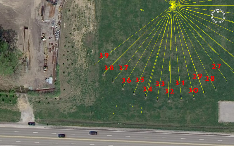
27. 200' @ 144-degrees (navigation, multi-use).
28. 202.5' @ 152.77777 ("11" system circumference divisions)-degrees.
29. 202.5' @ 160 (divisions of the compass, multi-use) & 340.2 (lunar nutation cycle)-degrees respectively.
30. 202.5' @ 166.66666-degrees (3,4,5, triangle, division within decimal progression).
31. 202.5' @ 354.375 (lunar year)-degrees.
32. 202.5 @ 181.44 (divisions of 1-degree of arc under the "6&7" navigational system) & 182.625 (solar year)-degrees respectively.
33. 202.5 @ 189-degrees (navigation under the "6&7" system, Sabbatical Calendar).
34. 202.5 @ 16 (divisions of the compass, multi-use) & 196.875 (lunar year cycle, ancient beqa gold standard weight)-degrees respectively.
35. 206.25' (Egyptian Royal Cubit devoted to the 24750-mile equatorial circumference) @ 26.25-degrees (Greek mile, lunar counts).
36. 206.25 @ 211.2-degrees (navigation by the "11" system).
37. 207.36' (Egyptian Royal Cubit devoted to the 24883.2 mile or "true" equatorial circumference) @ 217.8-degrees (navigation, division within the feet value of the 24750-mile circumference).
38. 207.36' @ 225 (360-degree compass divisions)& 45.36 (navigation under the "6 & 7" system, literal height and length of the Great Pyramid)-degrees.
39. 210' @ 52.5 (Greek mile, Hebrew reed, lunar counts) & 52.8 (English mile)-degrees respectively.