In the high, remote desert country, some 54 miles east of Phoenix, Arizona there is an enigmatic, ancient circle wall structure that could be described as an Indian Medicine Wheel.
The structure is impressive, with a 3 feet thick, reasonably high wall running
continuously in an almost perfect circle for about 430-440 feet (OD), interrupted
only by entry gateways. Like sites in Great Britain, there is a slight elliptical
shaping to the overall circle in the dimensions north-south as opposed to east-west.
This has the effect of providing an additional, 90-degrees opposed diameter,
which "doubles-up" the linear and circumference codes encrypted into
the site.
There is a flat section of wall over toward the east that appears to run for
about 44 feet before reverting to a curve. The site has two clear "spoke"
walls running out from the centre to the outer wall, as well as 4 "faint"
spokes, which are now somewhat more difficult to detect.
The Circlestone structure sits at an elevation of 6010 feet above sea level and, apart from nearby Mound Mountain (6266 feet) situated at an azimuth angle of 217-degrees from Circlestones, is one of the highest points of the region.
'Whoever built Circlestone commanded a view difficult to duplicate in this region. Mountain ranges seventy-five miles away are visible. To the west, Superstition Mountain and Weavers needle can be seen. To the East are the Sierra Anchas, and to the north Four Peaks and the Mogollon Rim dominate the horizon. To the south is Mound Mountain and the central valley of Arizona' (Circlestone, A Superstition Mountain Mystery, by James A. Swanson and Thomas J Kollenborn).
It is very evident that the so-called British Standard of measurement is of
remote antiquity and is not of British origin, but stems from ancient Egypt,
Babylonia and Sumeria. It is still true to its original length after untold
millennia and was most certainly the standard used in the construction of the
Circlestone Observatory.
Check the many articles of this website for supportive evidence related to the
antiquity of the Egyptian/ Babylonian/ Sumerian/ British Standard of Measurement...with
affiliated measures used amongst the Greeks, Hebrews & Romans, etc.
WHY WAS CIRCLESTONE BUILT?
The Circlestone structure is but one of several similar, circular stonewall sites that survive in the region. Another impressive structure of this type nearby is Casa Malpais. See: http://www.delange.org/CasaMalpais1/CasaMalpais.htm
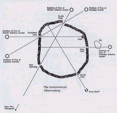
Figure 1: The Casa Malpais circle wall observatory, which orientates perfectly to solar positions through gateway alignments. There were once many such structures throughout the region, which shows us that ancient inhabitants of Arizona were very preoccupied with astronomy.
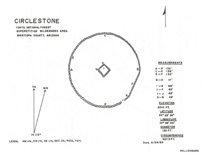
Figure 2: The Circlestone observatory, as measured by Tom Kollenborn and
his colleagues. This picture comes from, Circlestone, A Superstition Mountain
Mystery, by James A. Swanson and Thomas J Kollenborn.
In the above picture a small amount of error was detected in the drawing in
consideration of the measurement panel to the right, when it was taken into
AutoCAD for analysis. It's possible that the drawing was based directly on a
topographical photo and there was a slight amount of lens distortion in the
photo. The problem was easily rectified in AutoCAD and drawings used throughout
this study are corrected and scaled to Tom Kollenborn's recorded dimensions.
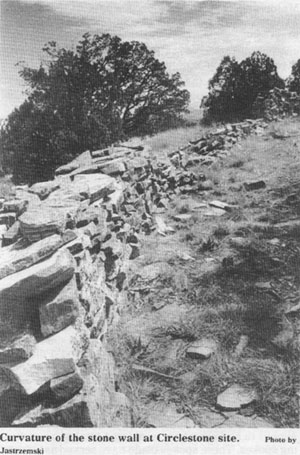
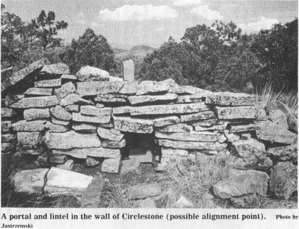
Figure 3: Another important marked point of the wall that probably relates to something happening annually on the distant horizon. The positions of any prominent features such as this need to be positively recorded and marked into the site plan.
THE SIGNIFICANCE OF CIRCLESTONE'S DIMENSIONS & ORIENTATIONS.
This must remain a preliminary study, based upon what is positively recorded about the site's known attributes. As more complete information becomes available, gaps within this analysis can be filled. Let's begin by introducing a site plan that is scaled to the dimensions given by Thomas J Kollenborn.
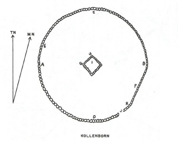
Figure 4: Tom Kollenborn gives us the following distances between marked
positions of his site plan. A to B = 132 feet, C to D = 136 feet, E to F = 130
feet, G to H = 17 feet, I to B = 68 feet, I to F = 62 feet, I to J = 68 feet,
K to B = 48 feet…so what is the significance of these dimensions?
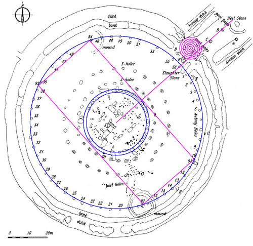
Figure 5: The Station Stones rectangle at Stonehenge was 264 feet long and 113.4 feet wide. It perfectly enclosed the Sarsen Circle in its width from 45-degrees azimuth to 225-degrees azimuth (the Sarsen Circle was made slightly elliptical to accentuate the 113.4-day lunar code…6804-days =113.4 X 60). Ninety degrees opposed to the 264 feet long eastern side of the Station Stones rectangle the sun rose on the day of the summer solstice…with "first glint" to the north of the Heel Stone at 48.6- degrees.
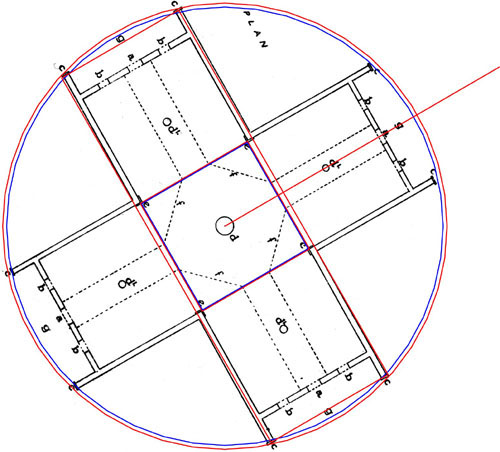
Figure 6: A strange former Maori meeting-house, which had a pedigree back to the mysterious Patu-paiarehe people … a civilization vanquished by the Polynesian Maori. The pre-Maori people of New Zealand fitted the description of Europeans and the ancient mathematics found within the coded structures of New Zealand attest to a strong cultural link to Europe and the Mediterranean. The Crosshouse of Miringa Te Kakara follows the identical surveying methodology of Stonehenge & Circlestone in its foundation coding. The elongated red rectangle running to the exterior of two wings of the building and defining the overall length to the outer facing plates is 52.8 feet (26.4 feet X 2). The width of the wings was intended to convey 17.01 feet (officially 17 feet), which is 1/8th of the 136.08 feet north- south internal length of Circlestone. It is also the exact length of (at least) the northwestern wall of Circlestone's inner square structure. The 17.01 feet lengths occurring at both Circlestone and Miringa Te Kakara's Crosshouse was for mnemonic reference to 1701-days…the duration of ¼th of the 6804-day lunar nutation cycle. At the Octagon of Newark, Ohio the largest defining square that could contain the octagonal section of the earthworks was coded to convey 1701-feet in diameter… ¼th of 6804 feet.
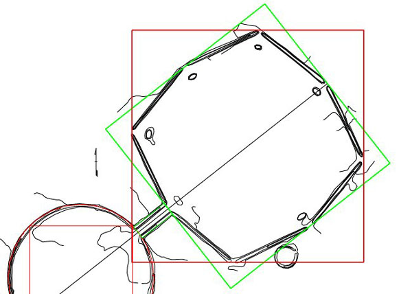
Figure 7: A red square of 1701 feet diameter frames and contains the giant octagon
component of the Octagon Earthworks at Newark, Ohio, USA.
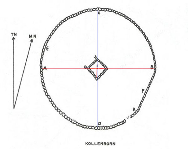
Figure 8: The red line (east-west) is scaled to indicate 132 feet and the blue line (north-south) represents 136.08 feet. The expected elements of a lunar code based upon 6804, running 90-degrees opposed to a navigational code based upon 264/ 528 are positively present within the observatory's official measurements.
The encryption of these 2 very important codes will (where the latitude allows) be accompanied by a 3rd code related to 486 or 243. These numbers are, in turn related to 6804-days (the lunar nutation cycle) or 2551.5-days (the number of days in 7.2 lunar years, used in conjunction with 7 solar years (2556.75-days) under the Sabbatical Calendar system…see The Calendar of Coligny article within this website for a full explanation).
A very important reason for placing the Circlestone Observatory in that exact location relates to the 486/ 243 code. The astronomical evidence shows that Circlestone was situated such that the winter solstice sunset would occur at an azimuth angle of 243-degrees.
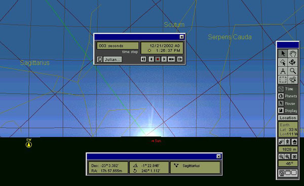
Figure 9: The winter solstice sunset, as it would theoretically relate to
Circlestone observatory. The only element that would affect this view would
be the height of the distant horizon to the WSW. Given the high elevation of
Circlestone at 6010 feet it's possible that a fuller winter solstice sunset
orb was observable at 243-degrees azimuth than that depicted above.
So, Circlestone is showing itself to be based upon the expected approach to setting up a coded structure. It incorporates the selfsame numbers, encrypted by the universal measurement standard that was used from continent to continent in the ancient world. The "misshaping" of the structure was very deliberate in order that important codes could be incorporated and extracted with ease. The codes themselves were a part of a "parcel" of numbers, which related to navigation, calendar determinations and the cycles of both the sun & moon…with a larger emphasis or accentuation of the lunar cycle. Let's extract the long dormant numbers anew and show how ancient priest/ astronomers were using the site as a memory device.
THE 6804-DAY LUNAR NUTATION CYCLE.
Tom Kollenborn states that the distance between C to D is 136 feet and, as discussed this would have meant 136.08 feet (less than an inch over 136 feet). This is 68.04 feet X 2.
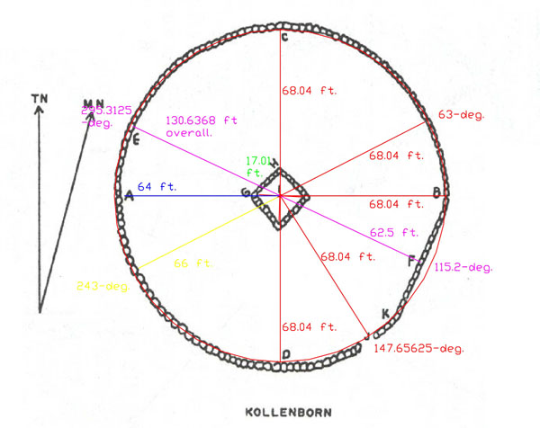
Figure 10: These are the probable coded distances and angles intended by the
builders to be demonstrated within Circlestone Observatory. Most of these relate
directly to the cycle of the Moon, with others relating to navigation and the
size of the Earth.
It is unknown to this researcher why Tom Kollenborn marked the positions of
E, F & K, but one assumes it was because a significant feature was present
in the outer wall at each of those points. The positions also closely coincide
with very significant degree angles, which are:
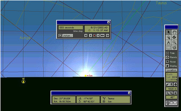
Figure 11: The summer solstice sunrise for the coordinates of Circlestone,
with the ½ orb of the sun above the horizon. The panel gives a reading
of almost 61-degrees, but this could vary markedly if the distant horizon, where
the sun emerged, was higher. Individuals on the site must determine the exact
observable azimuths for solstice rises and sets.
THE 486 LUNAR/ SABBATICAL CALENDAR CODE & PHI.
Throughout the ancient world there was copious use of PHI in coded structures
and PHI was of extreme importance to the ancient astronomical/ mathematical
methodology. Sometimes it was very vividly displayed, as it the case of Stonehenge,
where clearly marked circles are in a PHI relationship to each other.
On a small tutorial site like Circlestone it was essential to encrypt the universally
standard mathematical principle of circles and squares reducing in a PHI relationship
to each other.
The general rule of thumb was that the outer defining circle or most prominent
coded circle of an observatory would have a square overlaying it and there would
be a specific PHI relationship in the diameters of both circle and square. The
formula for finding the diameter of the square was to make it ½ PHI
less than the diameter of the circle.
On several sites around the world (like the Crosshouse of Miringa Te Kakara in New Zealand) it is observed that the outmost circle and square combination then reduces inward by PHI @ 1.6180339 (see articles in this website devoted to The Crosshouse of Miringa Te Kakara or Stonehenge).
This important PHI related methodology had to be strongly encrypted at Circlestone so that it would never be forgotten, ensuring that the mathematical principle could always be taught to initiates of the astronomical arts. If a vivid, demonstratable PHI station existed to provide an example of how the mathematical method worked, then any chosen number could be subjected to precise modification in a progressive process of PHI reducing circles and squares. The PHI station for Circlestone was provided by the flat section of wall to the east side of the site.
The primary benchmark surveying point for Circlestone was the winter solstice sunset at 243-degrees azimuth. This provided the main code upon which Circlestone was founded… which was the 243/ 486 code…also found upon the Calendar of Coligny (4.86 feet long) and at Stonehenge in the "first glint" summer solstice rise position (48.6-degrees).
This is how the "circle and square" PHI relationship principle was encoded at Circlestone:
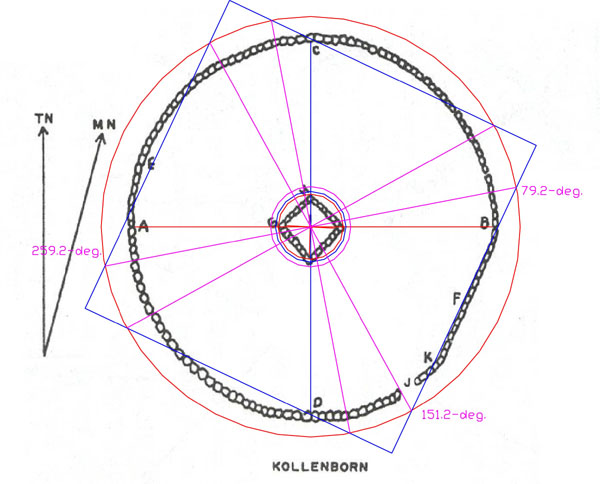
Figure 12: The foundation number used at Circlestone was 243/ 486 and the
"flat section" of wall was designed to call attention to a PHI reduction
on a circle of 486 feet circumference. Such a circle would have a diameter of
154.7 feet and the "square" that would overlay such a circle would
be ½ PHI reduced (.80901695) to 125.1535 feet. Kollenborn measured the
distance between site centre (I) to the face of the flat wall as 62 feet and
the ½ value of 125.1535 feet (radius of the blue square shown) is 62.57
feet. It's quite obvious that the flat section of wall, in one of its coded
readings, was designed to represent a ½ PHI diameter reduction on a circumference
of 486 feet.
Irregularities in the central square structure will be for encrypting additional
codes, but symbolically, the central region was read as 17.01 feet per side
in one of its readings.
It is highly likely that a "standing stone" or "cairn"
marker will sit/ once sat outside of the Circlestone perimeter wall and mark
the diameter of a circle with a circumference of 486-feet!