'In the course of normal science, it may happen that anomalies begin to accumulate. Some of these may be set aside for future research. Some may be dismissed as irrelevant. But if a sufficient number of anomalies accumulate, anomalies, which resist solution by the paradigm or incorporation into it, a crisis develops. As the crisis intensifies, scientists begin to offer and promote new paradigms capable of accommodating the anomalies. If one of these paradigms attracts the attention of a sufficient number of members of the research community, a scientific revolution takes place. The research community learns to see things in a different way. It develops a new set of methods and concerns. Kuhn points out that unless there is a recognizable crisis, provoked by an accumulation of crucial anomalies, there will be no movement to a new paradigm. The first step toward movement to a new paradigm is thus recognition of anomalies, of counterinstances to the current paradigm' (Michael Cremo).
In the United States, as elsewhere, mainstream concepts of history are under assault and there is a growing awareness that the accumulation of archaeological anomalies is forcing a major paradigm shift. Primary resistance to the shift is spearheaded moreso by the academic community than the by the indigenous population, who have attempted for years to tell the mainstream scholars of "other historical factors".
North American Indian historian, Vine Deloria jr. is righteously indignant
about the hijacking of history by do gooder paternalist Europeans, who are creating
a cozy, socially engineered pseudo-history for the Indian tribes of North America.
He sees this as European led condescension toward his people and complains,
'There's no effort to ask the tribes what they remember of things that happened.
He goes on to say, 'numerous tribes do say that strange people doing this
or that came through our land, visited us, and so on. Or they remember that
we came across the Atlantic as refugees from some struggle, then came down the
St. Lawrence River and so forth. There's a great reluctance among archaeologists
and anthropologists to break centuries-old tradition and to take a look at something
new...As for the history of this hemisphere from say, five thousand B.C. forward
to our time, the mainstream scholars just don't want to deal with that at all.
Let me give you an example. Years ago I spoke at an academic archaeological
conference, and at the end of my speech I asked, 'Why don't you guys just drop
the blinders and get into this diffusionist stuff?' My host, David Hurst Thomas,
just about lost it and said, 'Do you know how long and hard we've fought to
get members of this profession to admit that Indians could have done some of
these things? And now you're saying it was Europeans!'''.
A similar set of limiting parameters has been foisted onto us in our "New
Zealand" interpretation of regional history. Again, social engineers have
oftimes discounted as irrelevant and unreliable the oral traditions of the Maori
Elders and have taken a paternalist approach to creating pseudo-histories that
promote limited, santitised versions of Maori history, to the exclusion of all
else that went before.
All over the New Zealand landscape we are finding standing stone structures
used for astronomy, navigation and land-mapping. There is evidence of "Beehive
house villages and a large, former "Stonebuilder" population
Local historical interpretation is locked into a mere 800-900 years of human
occupation, with a marked reluctance to accept any significant occupation at
earlier epochs...in the face of, what many amateur researchers consider to be,
dynamic evidence of at least 5000 years of continuous human presence in New
Zealand.
Regional, social engineering of history is as much a condescending insult to
the New Zealand Maori people as it is to Deloria's North American Indian tribes-people,
in that it discounts their oral traditions and histories as being of little
worth or substance. We seem to be enveloped by an academic attitude of "forced
amnesia", which makes us forget truths that were general knowledge and
openly discussed up until about 3 decades ago.
New Zealand historical resources carry many recorded references related to a large population of pre-Polynesian "red headed, light complexioned Tangata Whenua", albeit mostly in rare, out of vogue books buried in the backrooms or basements of our libraries and archives. One can also source such references, if one asks politely, from the Maori Elders who have memorized the oral traditions of their Iwis (Maori tribal groups).
THE MAORI WHAREWAENANGA (SCHOOL OF LEARNING).
It is the purpose of this study to show evidence of an early pre-Polynesian people, resident in New Zealand, whose former presence is attested to by many ancient ruined structures from the pre-Maori epochs. This evidence lies scattered across the length and breadth of New Zealand. It can be demonstrated that aspects of a regionally identifiable, Northern Hemisphere knowledge was handed down, at least in part, and survived within the Maori Wharewaenanga.
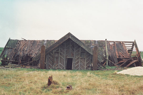
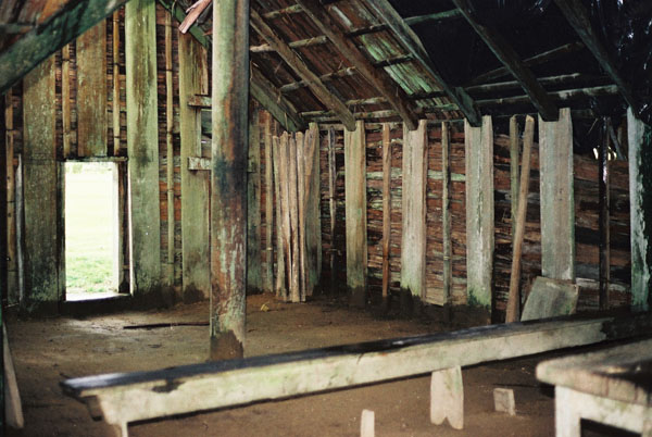
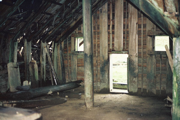
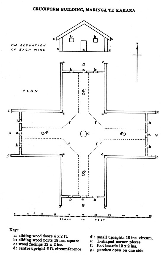
The dilapidated Crosshouse at Miringa Te Kakara, central North Island, New Zealand, shortly before it was burned down in 1983. Photos appearing in this article courtesy of Jan & Ron Raison.
Let us turn our attention to one such Wharewaenanga, School of Learning, established
by the Pao-Mirere or Hau Hau movement at Miringa Te Kakara in the center of
the North Island.
There appears to be some confusion as to the date of this building's construction
and disagreement amongst the Maori Tohungas (sages) as to whether or not Pao-Mirere
activity, related to the "Crosshouse", was to construct an entirely
new building or simply to renovate to an older existing structure.
It is known that a series of Wharewaenanga structures bearing the name Miringa
Te Kakara or Waerenga A Kakara had existed for centuries. Similar "temple"
structures were located at 3 other regional centers contempory with the era
of the Crosshouse.
The building, initiated by King Tawhiao's directive to Chieftainess
Ngaharakeke, is said to have been completed in about 1865. Bishop Thomas
Herangi, guardian of the Crosshouse up until the 1980's, cited evidence
of the star temple having been built in 1682, with renovations occurring in
1788 & 1887.
The main interest in this building must lie in its geometric and measurement
attributes, which code astronomical and navigational knowledge found from Egypt
to Great Britain and North America.
The key to extracting the international parcel of codes lies in an understanding
of the common measurement standard being used internationally by an ancient,
highly mobilised migrating group, who set up colonies all over the globe. Many
of these colonies appear to have begun as metal ore mining operations.
The Crosshouse of Miringa Te Kakara was not some form of "orphan"
dwelling, the attributes of which are unique to New Zealand. It was built according
to an internationally distributed parcel of astronomical codes, in accordance
with a measurement standard that migrated throughout the ancient world and spanned
oceans.
Careful, in depth surveying research into the dimensions of astronomical sites
over several continents shows that the so-called British Standard of measurement
isn't originally British at all, but is Egyptian/ Sumerian/ Babylonian. This
concept can be severely and finely tested mathematically by trigonometry on
internationally distributed structures built to this singular measurement standard…
from the Giza Plateau to Stonehenge to the Octagon of Newark Ohio… to the
Crosshouse at Miringa Te Kakara.
THE DIMENSIONS OF THE CROSSHOUSE.
Over the years several publications have mentioned close approximation measurements
of the Crosshouse, like the 1959 Journal of the Polynesian Society article,
which gives the following description.
'This building is 54 ft in length along the north-south and east west axes.
Each wing is 17 feet wide and the height to the ridge poles is 11 ft. 6in.
Each wing has a small open sided porch and entrance to each is gained through
a sliding door hewn from one piece of timber 4 ft high, 2 ft wide and 2 ins.
thick...Each portal is fitted with two ports to admit light and these are closed
by solid wooden slabs about 18 ins. square and 2 ins. thick, which are slid
into position....The walls...are about 6 ft. high. Inside the building will
be seen 5 uprights, which have been set in the ground to support the ridge poles...the
centre pole is about 6 ft. in circumference while the other 4 are 18 ins. in
circumference. At the inner corners of the cruciform structure are some L-shaped
corner pieces 2 ins. thick... About 6 ft. in from each wall are footboards about
12 ins. wide and 1½ ins thick.
The most accurate, detailed plan ever made appears to be that of architect
C. G. Hunt in 1958 for his 1959 article in the Journal of the Polynesian
Society, 68: 3-7. Hunt's scaled plan has been used in this mathematical analysis
of the Crosshouse. The full analysis tests geometry detectible at the Waitapu
standing stone circle in Northland, NZ, against similar geometry found at Rennes
le Chateau in Southern France by former army surveyor David Wood and his team.
Careful work undertaken in the Languedoc Province showed very clear trigonometric
evidence of known British Standard measurements like the mile. David Wood's
work verified that a Celtic cubit of exactly18 British Standard inches existed
in the placement of ancient structures of the Renne's valley and the measurement
standard found there was the modern British one.
It can now be demonstrated that "slightly drifted" "weights,
measures & volumes" of the foremost civilizations of the Mediterranean
have stemmed from one common source in Egypt and the British system is the most
intact survivor of the original universal system. Even the strange Egyptian
cubits are fully a part of the "so-called" British Standard of Measurement.
The Plan of C. G. Hunt was for the perceived purpose of "restoration" of the Crosshouse building and did not take into account the structure's correct orientation within the greater landscape. Hunt's plan shows the building's wings orientating onto North, South, East & West, whereas 2 wings actually lay along the observable rise/ set line of Winter solstice sunrise and Summer solstice sunset at 60-degrees and 240-degrees respectively. The other two wings lie, therefore, at azimuths of 150-degrees & 330-degrees.
In consideration of the slightly elevated hills to the NE & SW, it's probable
that the Winter solstice sunrise and the Summer solstice sunset were observed
from the center pole or secondary poles through the open doorways. It's also
highly likely that the northern-most Lunar Standstill rise and the southern-most
Lunar Standstill set could be observed through the elevated windows, with the
observer seated to the front or side of the center pole.
The exact position of the Crosshouse's center pole is determined by the distant
peak of Mt. Ranginui, which lies directly north and provides the benchmark fix
for the structure and its outlying nui poles. The Crosshouse was described as
a place for "conducting the rites as in old times".
The mathematical attributes of the Crosshouse show us very clearly what many
of those rites were and how they parallel astronomical and navigational knowledge
preservation activities undertaken by priests within the great civilizations
of the Northern Hemisphere. The knowledge coded into the Crosshouse at Miringa
Te Kakara has a direct pedigree back to Egypt, Great Britain and North America,
as elsewhere.
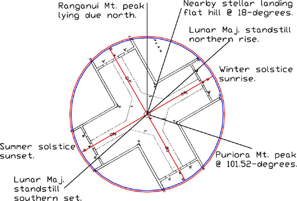
The correct orientation of the Crosshouse, using the peak of Mt. Ranginui
as the benchmark for true north from the building's center pole. Two wings were
set out along the line of the Winter solstice sunrise and the Summer solstice
sunset positions, which, in consideration of slightly elevated outer terrain,
should have been observable at 60-degrees and 240-degrees respectively.
It also appears apparent that an observer seated at the base of centre pole,
viewing upward at an angle of about 7.5-degrees through the NE window would
observe the Major Northern Standstill position of moonrise and through the SW
window the Major Southern Standstill moonset. Alternatively, the observer could
sit on seats to the right and left of the pole and watch not only the major
standstill rise and set but, plausibly the minor standstill rise and set also
through the adjacent window on the other side of the doorway.
This concept is supported by a late era tradition of reflecting direct moonlight
beams from paua shells onto incised symbols within the building. All indicators
suggest that the 18.613-year lunar cycle was being tracked.
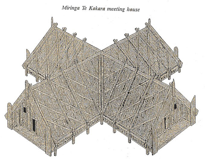
Drawing by W.A. Taylor of how the cruciform building looked when in pristine condition.
GEOMETRIC PRINCIPLES.
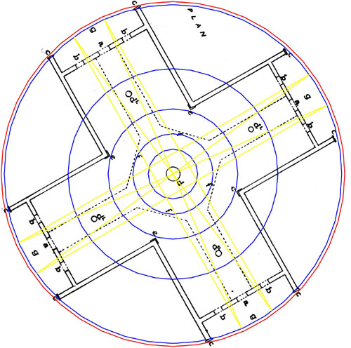
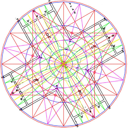
The 1958 Crosshouse survey plan of C. G. Hunt seems to indicate a slight elongation of two wings, which allows them to sit within a circle of 56 feet and the 90-degrees opposed wings to sit within a circle of 55 feet. These numbers are of extreme importance to navigation or calendar counting systems found from Egypt to Great Britain and North America. Let's now consider some mathematical attributes:
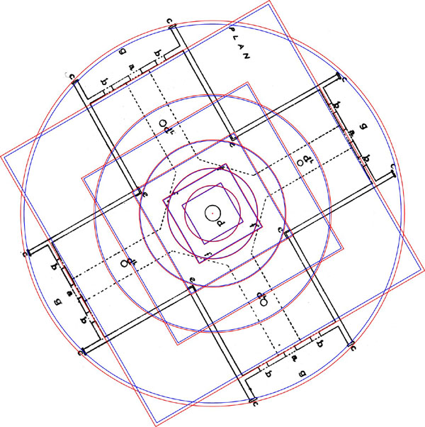
PHI reducing circles and squares define significant positions within the
Crosshouse.
From Egypt's Great Pyramid to Stonehenge in Southern England the geometric principle
of PHI reducing circles and squares has been observed to be a significant factor
in the defining geometry of observatories or code bearing structures.
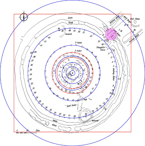
PHI relationships at Stonehenge… Avenue marker, Aubrey Circle, "Y" Holes circle, Sarsen Circle, etc.
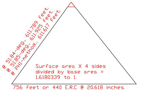
The ratio between the upper surface area of the Great Pyramid (assuming a symbolic capstone) to the surface area that the Great Pyramid occupies at its base = 1.6180339 (PHI) to 1. The PHI method for arriving at a side diagonal value of 611.617 feet is: 378 feet (½ the base length) X 1.6180339 (PHI).
SIGNIFICANT DEGREE ANGLE CODES WITHIN THE CROSSHOUSE.
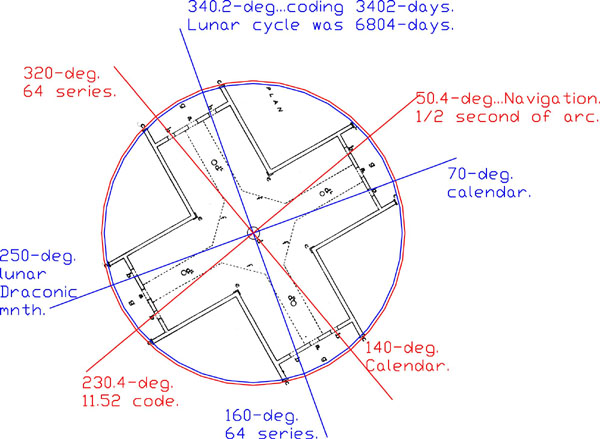
It is known that the Sumerians, Babylonians, Greeks and other great civilizations of antiquity, used an ancient system of dividing a circle into 360-degrees or 720 calibrations. Their method persists in modern times. The Crosshouse at Miringa Te Kakara (Tiroa) incorporates the same system and clearly encrypts solar, lunar and navigational codes (via the degree angle numbers generated) used universally in the ancient Northern Hemisphere.
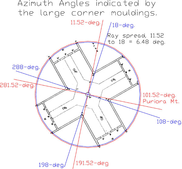
A very important code found from Egypt to Great Britain North America and South America is based upon 11.52. Under the ancient Babylonian system of time measurement (days, hours, minutes and seconds) the Heliacal rise of Sirius gave a close approximation of the Solar year @ 365.25-days. From this figure was deducted 11.52 minutes to render the figure 365.2420-days (Mayan Calendar). The red vectors are expressions of 11.52 increasing at intervals of 90-degrees. The second increase in the series designates the azimuth angle to Puriora Mountain, indicating that the Crosshouse was precisely positioned to be (1) due south of Mt. Ranginui and (2) 11.52 + 270-degrees WNW of Puriora Mountain's peak.
Each of the blue vector azimuths produce extremely important astronomical/
navigational numerical codes used over several continents in antiquity. An example
of this (288) relates to The Great Pyramid, Menkaure Pyramid, Stonehenge's Aubrey
Circle and astronomical codes encrypted into the Bible in Num. Chpt. 7. Code
encryption appears to have been the true preoccupation of many biblical writers.
The degree angle spread between the two edges of these very prominent, large
wrap around corner moldings was obviously intended to convey 6.48-degrees, using
the center post as the fulcrum. The 6.48 code is of extreme importance within
an ancient mathematical progression, which relates to the duration of the Precession
of the Equinoxes…6.48, 12.96 (½ the precessional cycle was 12960-years),
19.44, 25.92 (Precession was calibrated to endure for 25920-years). Another
important number associated with this progression includes 51.84 (angle of the
Great Pyramid's sides & 1/500th of the duration of Precession in years).
It is important to note that the 6.48-degree increment features strongly at
the huge Octagon earthworks geometric complex at Newark Ohio and features within
the chosen design angles of 8 embankments. One of the embankments resides on
an azimuth angle of 64.8-degrees.
A part of a "wrap around" corner molding can be seen to the right hand side of the above picture. It will be noticed that half of a strange geometric design is etched into the timber, with the rest of the design continuing around the corner onto the 90-degrees opposed face. Each large corner molding, as well as the centre post, had either the same (4-pointed star) geometric design carved into it or a variation of the design.
Degree angle codes as they relate to the sides of the windows. All of the
numbers shown are highly important to ancient systems of calendar counting,
navigation and determining the size of the Earth… or counting days within
the 18.613-year lunar nutation cycle.
The occurrences of degree angles related to 50.4, 230.4 and 340.2 are especially
dynamic, as these are amongst the most important codes of antiquity and are
found upon the Great Pyramid, Khafre Pyramid, at Stonehenge or within the Octagon
of Newark, Ohio.
STAR & CROSS PATTERN GEOMETRY.
The work of David Wood and his team in Rennes Le Chateau in the Languedoc Province of Southern France, showed that overland positions of ancient structures situated within the Rennes valley, demonstrated star and cross pattern geometry. A huge hexagram, pentagram, an 8-pointed star and several forms of crosses were clearly identifiable in the carefully surveyed former positions of ancient "Pagan" sites located there.
What David Wood identified is repeated in whole or in part at individual observatories
of coded structures around the globe. Many aspects of his team's findings are
most certainly incorporated into the Crosshouse at Miringa Te Kakara and represent
a standard astronomical system taught to initiates. Knowledge of the universal
system allowed accurate astronomical/ navigational calculators to be built worldwide.
The ancient people were very practical and every star or cross pattern had a
prescribed, useful purpose that would aid in the preservation of knowledge and
optimization of regional functioning society.
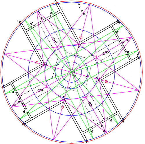
THE 8-POINTED STAR.
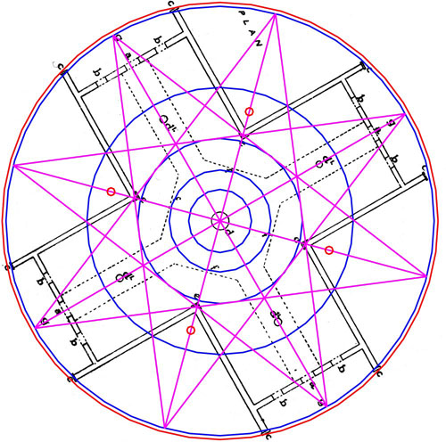
During a survey of 1/7/2001 it was discovered that there were 4 additional posts close to the internal corners of each wing, which surveyor C.G. Hunt had not included on his 1958 plan. These were found to reside just over 14 feet from the center in the positions shown. Also the secondary posts shown on Hunt's plan were measured to be a few inches closer in than where Hunt had marked them. This infers "expert consultation" between Hunt and Pao-Marire Kaumatua's as to the correct positioning of those posts.
The 8-pointed star in normal North-South orientation would have its rays extending toward the primary and secondary positions of the compass. In the geometry of the Crosshouse the rays extend to 15, 60 (solstice), 105 (reed), 150, 195 (calendar), 240 (solstice), 285 and 330 (navigation) degrees respectively.
Note how the 8-pointed star geometry relates to positions within the building. Returning lines intersect with the edges and centre of the 4 corner moldings and the 3rd inward PHI circle is perfectly contained within the star. The ends of the walkways terminate widthwise onto the ray lines of the star.
In Egyptian mythology the 8-pointed star is associated with Isis…also known in the region as Ishtar or Astarte.
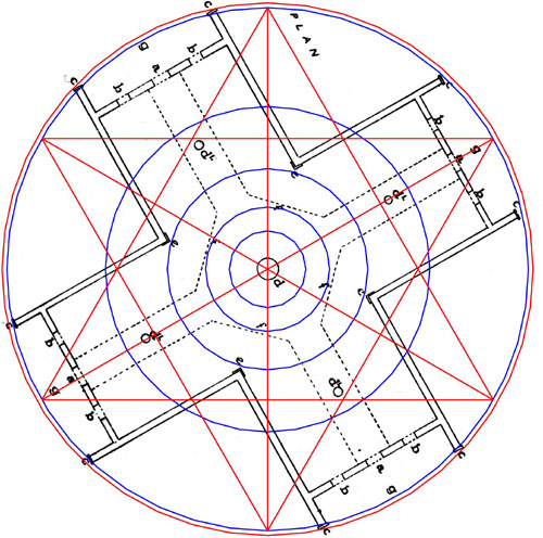
THE GRAND CROSS.
Amidst the geometry detected at Rennes Le Chateau by David Wood and his
team was a Grand Cross.
This is also clearly in evidence at Miringa Te Kakara, where the width of each
cross arm, designated by the extreme positions of the Crosshouse windows, is
24-degrees of arc.
There are 8 intersection positions on the 8-pointed star that clearly stipulate
how the Grand Cross is constructed and how it overlays the 8-pointed star geometry.
This cross remained prominent in the symbolism of many ancient Northern Hemisphere
civilizations and developed into the Knight's Cross, the Templar Cross, etc.
This cross, when combined with an overlaying PHI circle is recognizable as the
Celtic Cross.
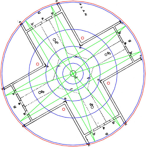
The Grand Cross, clearly designated by extreme window positions within the
Crosshouse. Overlaying PHI circles, adding to the geometry, create the Celtic
Cross…much displayed in regions like Ireland.
The Grand Cross overlaying the 8-pointed star. Note how intersections of
the star lock the cross pattern firmly into position. The diagonal vectors numerical
values within this cross pattern are highly important to known ancient astronomical/
navigational methodologies.
THE 6-POINTED STAR & THE 12-POINTED STAR.
These two star patterns were highly important to tracking the sun at the solstice or fixing onto the constellations of the zodiac (12 houses…30-degrees apart).
This is a very useful star pattern, especially at latitudes like Miringa Te Kakara, inasmuch as the ray points of the star fix onto the 4 rise and set positions of the solstice sun, with the 2 additional points designating north and south. Near Eastern tradition seems to suggest that this was the star pattern assigned to RA the Sun God, which would make perfect sense.
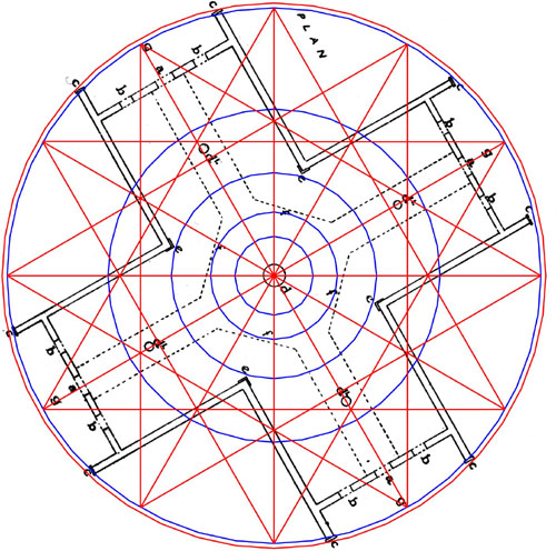
The 6-pointed star doubles out into the 12-pointed star, thus designating
the positions of the 12 houses of the zodiac, with a spread of 30-degrees of
arc for each house. Note how intersections of this star comply with the internal
wall line of the Crosshouse.
THE CROSS OF SET.
David Wood and his team detected a thin cross within the marked positions of
Rennes Le Chateau. A central PHI circle and intersections within the layered
geometry of the Crosshouse attest to the presence of this thin cross in the
geometric design of the Crosshouse. Whereas the Grand Cross has an arm thickness
of 24-degrees, the thin cross extends through 12-degrees.
THE "ALL IN" GEOMETRY SO FAR.
The Maori religious movement "Ratana", which has a strong affiliation to the Pao-Marire movement of the 1860's, continues to use symbols or patterns borne out of the geometry of the Crosshouse as religious emblems of their faith. These symbols were handed down from the ancient Patu-pai-arehe, some of who were ancestors to the Maori descendants from the Takitimu canoe. The main group of Patu-pai-arehe in residence at Tiroa was finally vanquished from the valley region into the high seclusion of the Rangitoto Ranges.
It becomes evident as to why 4 special post positions were made near the outer corners where each wing began. In the above picture the posts (red) are shown to be major intersections for crossing geometry. This star and cross pattern geometry is steeped in antiquity and both the squatting god (Ammon RA) of the Egyptian Hypocephalus funerary amulet or the squatting god of the New Zealand Moriori people stem from a design created by parts of this geometry. How this occurs is explained in detail within this website (see Article, Megalithic New Zealand parts 1-6).
CREATING PHI GEOMETRICALLY AT THE CROSSHOUSE.
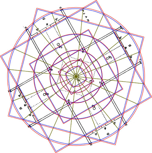
The windows of the Crosshouse provide the necessary 18-degrees of spread
to easily create 2 separate sets of PHI relationships between a circles and
squares with the diameter of the square ½ PHI less than that of the circle.
Ropes strung between the internal corners of the porches gave a reading to create
an accurate PHI overlay for the 55 feet circle (blue) and two wings were a ½
PHI reduction to a 55 feet circle. Two additional wings related to an encompassing
circle of 56 feet (red) and a square reduced by ½ PHI of that diameter
designated the internal length of the building for the wings concerned.