In 1998 a group of so-called "alternative" researchers of New Zealand's
hidden history were invited to participate in a TV documentary, later released
under the title, "Who Was Here Before Us".
Two participants were Gary Cook and myself and we chose to show the film crew
evidence of very early, pre Polynesian occupation at the Waitapu Valley in Northland,
New Zealand. It was our hope to explain in detail ancient astronomical/ surveying
endeavours that had once occurred in and from the valley, which were clearly
attested to by many purpose built stone structures still in existence there.
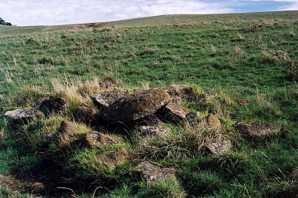
Figure 1: A solitary cairn in a farm field of the Waitapu Valley. This
is a purpose placed, very ancient surveying structure used for precisely marking
a position. Many cairns like this, distributed over several square miles, are
not the result of modern farmers gathering together stones from the land and
placing them in heaps.
To our disappointment, the film crew were on a tight schedule and weren't able
to truly assess the evidence we desired to present or film the many important
ancient trig marker positions.
Many months later the television viewing public were made aware of the fact
that some of us were "at variance" with the official version of local
history, but those watching the documentary were left with the erroneous impression
that we were unable to proffer anything substantial enough to support our contrary
points of view. Much to our chagrin, the outcome was that New Zealanders were
left no wiser about the true, long-term history of their country, nor made aware
of compelling evidence of pre-Polynesian occupation.
It had also been Gary's and my hope that we could show sufficient anomalous
archaeological enticements to excite the interest of the academic community
and that they would, at some stage, wish to visit the Waitapu Valley to assess
the many structures for themselves.
I was especially hopeful to have professional surveyors come to see how their
ancient counterparts had set up land mapping trigs that related directly to
the positions of regional mountains; how they had cleverly devised a system
of carefully measured baselines for triangulating the angles and distances to
prominent overland features; how they had laboriously fashioned a land benchmark
rock cleft to conjunct with a sea horizon datum and, from this dynamic surveying
feature, were able to accurately calculate the elevations of distant landmarks.
One wouldn't consider it unreasonable to expect a few professors of "this or that" to clamber out of their ivory towers for a day or so to consider claimed "physical evidence" of standing stone circle observatories, cairn marker humps, hillcrest tor mounds, standing stone surveying trigs, a carved benchmark position, beehive house village ruins…etc.
But, alas, no one amongst our learned elite could find the time or muster the
inclination…it was all just, "too much bother" having to deal
with such obviously spurious claims that would sap and waste one's valuable
time in unproductive pursuits.
Sadly, at this juncture three years further down the track, the experts are
still patently disinterested in investigating the Waitapu Valley structures
or alerting the public about what's there … so in the best tradition of
the Little Red Hen (and her chicks), 'I'll do it myself' (with the help of a
brood of research colleagues).
PRE-POLYNESIAN ASTRONOMY AND SURVEYING METHODOLOGIES 101.
New Zealand is a very old and long occupied country, despite the prevailing
wisdom of academia…who are reluctant to admit that there was any significant
human presence before the arrival of Maori Polynesians around 1250-1350 AD.
We are told that prior to about 800-years ago the country was a deeply forested
haven for insects and a sanctuary for birds, several species of which had become
flightless due to having no mammal predators.
There is some vague, elusive and almost ethereal, reference to an early group
of Polynesians known as Moa Hunters, who predated upon the giant, flightless
Moa birds and hunted them to extinction, but little is said or recorded about
these people.
Official human history for New Zealand begins with the advent of the Polynesian
Maori in about 1250-1300 AD.
One doesn't have to look very far or probe very deep to see grave frailties in the official explanation, as New Zealand is covered in remnant structures left behind by a stone working culture. This pre-Maori civilisation built canal systems, thousands of sculptured hills, wetlands agricultural systems composed of laboriously dug drains, beehive house villages, an extensive network of overland walkways, a system of very visible cairn hump or tor mound markers on the crests of low hill ranges. They constructed multiple standing stone circles for astronomy in locations where the distant regional terrain gave clearly defined views onto solstice or equinox sunrises and sunsets or more sophisticated fixes onto star and constellation ascents or descents.
One of the foremost preoccupations of ancient New Zealand scientist/ mathematician/ astronomer/ surveyors was land-mapping and marking locations on hill and in vale using carefully placed surveying trig positions composed of single standing stones or cairn heaps.
Let's focus on one very important regional centre within New Zealand where
large-scale land mapping commenced, then moved further afield from mountain
to mountain across the country. We will endeavour to gain an understanding of
the mathematical methodology employed in this ambitious ancient undertaking,
which, through exacting geometry, divulges the measurement standard used. The
lengths and angles between marked trigs are taken from a universally utilised
parcel of coded numbers, used from Egypt to Britain, the Americas and down into
Oceania.
New Zealand lies on an approximate north-south alignment and stretches for over
1000 miles. It has a coastline about as large as that of the United States.
SO HOW WOULD ANCIENT SURVEYORS GO ABOUT MAPPING AN ENTIRE COUNTRY?
The first step would entail finding a perfect location from which to start. Such a location would need the following attributes.
THEN THERE ARE THE ESSENTIAL TOOLS OF THE TRADE AND THE ACCOMPANING BACKGROUND MATHEMATICAL KNOWLEDGE REQUIRED TO USE THEM EFFECTIVELY.
Footnote: The ancient Egyptian measuring rope (the old term for "surveyors"
was "harpedonaptae" or rope-stretchers) was treated to hold its length.
It was stretched taut between stakes and then rubbed with a mixture of beeswax
and resin. Some of the ropes depicted in hieroglyph were graduated by knots
tied at intervals. Accuracy was creditable, according to a 1909 triangulation
survey that tied some original boundary stones. The Egyptian crews set the stones
to divide the fertile Nile delta, and the "rope" was indispensable
for measuring the distances.
Such simple, but accurately fabricated devices in the hands of adept surveyor/ mathematicians with sharp visual ability, could achieve excellent land-mapping positional accuracy…as we will see.
THE WAITAPU VALLEY…THE PERFECT LOCATION.
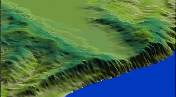
Figure 2: The rugged and picturesque Waitapu Valley at Maunganui Bluff, centre of highly developed astronomical, navigational and land-mapping activity in ancient times. The valley floor is composed of dark, fertile volcanic soil and many artesian springs, originating on the surrounding hills, ensure an ever-abundant supply of water. This location must have, anciently, been an idyllic place to live, with many available resources of food. The long, flat ridge of the Tutamoe Range due east of the Waitapu Observatory lent itself admirably to astronomy.
The Waitapu Valley appears to have formerly been a volcanic cone that blew out on its eastern and western extremities and the fertile valley floor now sits between 600-650 feet above sea level. To the western end of the valley molten lava once cascaded straight down into the sea, forming sheer cliffs of durable volcanic basalt rock. Rising reasonably steeply upward on the southern side of the valley is the long straight ridge of Maunganui Bluff, lying predominately east to west, with high sheer cliff faces on its western seaward end. Its overall height is just over 1500 feet above sea level and from Maunganui Bluff's wide flat summit spectacular views are possible through 360-degrees.
The northern side of the Waitapu Valley, similarly, has a high, elongated ridge
running east to west and achieves a fairly even height of around 1000 to 1200
feet above sea level throughout much of its length.
From ridge to ridge across the valley would be about 5800 feet (1.77 kilometres)
between high points at the western end and 7200 feet (2.2 kilometres) more centrally.
Conveniently, to the western, seaward end of the valley there are fairly wide,
lower flat plateaus north and south on opposite sides of the valley directly
above the sea cliffs. These are, undoubtedly, the remnants of the former western
rim of the volcano, which was breached by out-flowing molten lava. Both plateaus
sit at a comparable height to each other at about 825 feet above sea level and
some 275 feet above the lower valley floor.
As good fortune and a freak of natural geology would have it, there is a distant, high, level range directly out to the east. This is the Tutamoe Range and its long skyline ridge provides a perfect platform edge for greeting the rising sun throughout the year. Ancient astronomers could use its backbone for watching the Sun's annual journey down the horizon from the winter solstice to the equinox. The summer solstice sunrise could be observed on Maunganui Bluff's ridge.
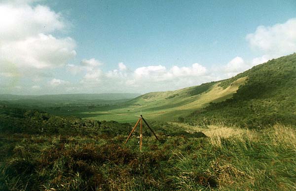
Figure 3: The view from the Waitapu standing stone observatory, where the stones were pushed over when the site was destroyed (probably by conquerors). Beneath the long grass and bracken are large stones, some in excess of 6 feet and shaped like sharks-fins. Directly east of the observatory is the long, flat Tutamoe Range, along which the rising sun could travel and be daily monitored from winter solstice to equinox. Summer solstice rises occur up to the right side of the picture on Maunganui Bluff's ridge.
The northern plateau is a perfect location, in every respect, for a standing stone circle observatory, a factor that did not go unnoticed by the ancient inhabitants of New Zealand, who set out carefully placed stones to fulfil that very purpose.
But they went considerably further than just sighting onto the rising sun,
moon or stars to the east and, in fact, turned the whole valley into a giant
versatile observatory, with miniature sighting stations scattered throughout,
which afforded views to the north, south, east and west or to any interim point
of the compass. Long flat ridgelines to both the north and south acted as alighting
or takeoff positions for stars decending or ascending.
In combination with outstanding astronomical endeavours, the ancient scientists
used the accurate angles derived from observing the sun at the equinoxes or
solstices to determine the compass positions of regional mountains. A very important
component part of the Waitapu Observatory is devoted to accurate land-mapping,
with extended trig points directly linked to the resolving hub stones of the
dual circle observatory.
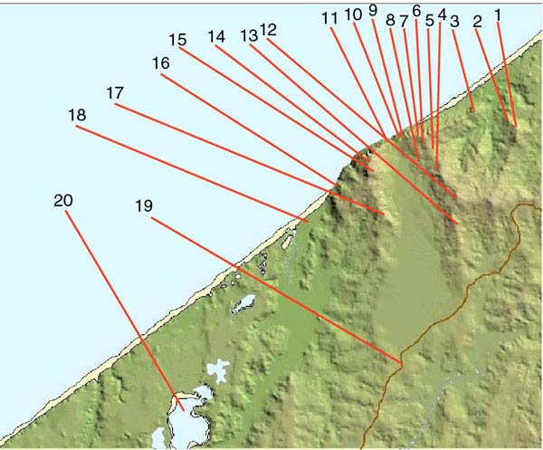
Figure 4: This picture shows the locations of some of the ancient astronomical
observatories or trig/ mapping structures still in evidence within or near to
the Waitapu Valley. Also shown is the present day coastal road bypassing Maunganui
Bluff and the Kaiiwi lakes. Many more positions could be added.
Description of sites shown:
1. Puketapu cairn observatory, located on the northern side of Puketapu Hill. The main observatory is composed of about 200 individual cairns (up to about 10 feet across and about 2 feet high), as well as a remnant horseshoe shaped wall of formerly stacked stone, now collapsed. Further up on the hill toward the summit are a series of elongated sighting pits extending toward Maunganui Bluff and also a high hill on the seaward cliffs (adjacent to and slightly north of Maunganui Bluff). In a saddle of the southeastern summit is a cluster of cairns and nearby is a large natural rock outcrop, visible for miles. This conspicuous large buttress feature, in conjunction with adjacent cairn and carefully positioned boulder markers, was used as a primary surveying benchmark. Cairn markers also lie on its steep ESE or SW faces and these would have been visible for those with keen eyesight, from atop Maunganui Bluff, 3-miles southward.
2. A lower plateau down from the Puketapu observatory seems more particularly devoted to overland alignments and mapping directly between Maunganui Bluff and regions northward. It acts as a significant interim station between a high distant mountain of the Northern Hokianga and the summit of Maunganui Bluff, 180-degrees opposed. A cairn marker indicates an alignment between this site's very large hubstone boulder and the "most targeted" distant northern mountain at Pungaru. The plateau has a series of standing stone or cairn markers, as well as an incised stone that might indicate a direction of alignment. On the seaward side of the approach road leading to Puketapu Hill are 3 large observatory sites in a row, the most southern of which has a particularly large stand of hubstones in a line.
3. A prominent high seaward hill with shadow cleft terraces cut into its northeastern face. The summit of this hill appears to have been used as a baseline station in ancient surveying endeavours. Associated with this steep sea-cliff hill are reported to be a series of sighting pits in the saddle of the hill to the southwest (now overgrown). Close by is a significant large cairn that marked alignments to Puketapu Hill.
4. On the northern slopes of the Waitapu Valley are 5 prominent alignment stations, each marked by impressive hubstones. The stations, distinctly separate from each other and individually quite big, utilise a singular large, purpose built "tor mound" structure on the valley's southern ridge to align onto a series of mountains to the south. They also relate to a gap between mountains to the east, where a prominent, more distant mountain can be seen. Other stations throughout the valley have marked alignments to this same mountain.
5. Slightly over the ridgeline on the northern side of the valley is a prominent stone circle marker composed of many placed boulders and designed to be seen from a considerable distance away. It acts as an interim, visible position between Puketapu Observatory and the summit of Maunganui Bluff.
6. Near this station, over on the southern side of the ridge, are a series of "patch markers" laid out on the hill slopes. These are large squares made up of many stone component parts that acted as visual markers from stations in the southern and south-western areas of the valley.
7. One of the highest locations in the area is a seaward hill, situated above the sheer cliffs. At a point of its wide summit, affording 360-degree views, are about 8 sighting pits in the overgrowth, one of which is marked by a standing stone and adjacent, small standing stone circle (boulder-type). The pits appear to orientate toward the tor mound on the ridgeline of Maunganui Bluff, but also would have served as sentinel locations to watch the northern beach extending for miles, all the way to the Hokianga Harbour entrance. On the line of sight toward the tor mound eastward, but at lower levels of the hill, are two impressive standing stone obseratories now encompassed by the forest.
8. On the same line from the summit of the seaward hill toward the two standing stone circles in the forest, then onward to the southern ridge tor mound, are impressive markers in the farm field, one of which was an intact stone circle prior to 1987. At that time, farmers doing scrub clearing moved about 5-7 outer marker boulders with a tractor and piled them onto the central, immovable hubstone. Nearby, up the hill northward, is an undisturbed cairn marker and there's also a second standing stone station slightly downhill to the southeast. A formerly large obelisk marker (now fallen and broken) lies by the fence near the farm house.
9. On the frontal cliffs is a jutting plateau that was a very important junction for multiple alignments. It has 4 very recognisable trigs, composed of standing stones and cairns, as well as a larger observatory, in the forest to the east, associated with it. There are several unplotted cairn heaps, now covered in bracken bushes, residing to the north and northeast of this site and all available evidence suggests the area was once a major junction for alignments.
10. Down the hill to the south of this important plateau junction is the Waitapu, dual circle , standing stone observatory. It is a world-class observatory situated on wide terrain adjacent to the seaward cliffs. Directly east of it is the distant, elongated and flat Tutamoe Range…a perfect location for monitoring the progress of the rising sun as it moves seasonally up and down the range from winter solstice to equinox, or further around onto Maunganui Bluff for the summer solstice sunrise. To the north of the observatory, linking the observatory to the upper trig plateau, are a series of uphill trig boulders at increasing elevations.
11. At a distance of 2000 feet south of the Waitapu Observatory is a sea cliff benchmark cleft. This is a level-cut feature that gave ancient surveyors a starting elevation that could be distributed across country. Beneath the cut benchmark is an almost sheer drop to the sea, some 960 feet below. This unique, carved feature proves to be one of the most essential and important surveying markers in the entire valley.
12. Returning to the northern side of the valley, one encounters the highest point on the central ridge. This location provided 360-degree views and acted as a baseline end station for triangulating onto mountains to the east, north and south. Associated baseline stations were the summit of Maunganui Bluff to the south and the high sea-cliff hill to the west.
13. On the northern ridge of the valley is a purpose built tor mound, visible for miles. It's surrounded by dilapidated cairns and former standing stone markers. These cairns mark coded distance and angle alignments from the benchmark cleft on the sea cliff and the southern ridge tor mound to the south, as well as other cairn markers on the southern ridgeline. A major surveying baseline station is situated on this plateau in the form of a sighting pit, with wide vistas onto mountains east and south. The pit and adjacent tor are also strategically positioned for sighting the same northern mountain (at Pungaru) that is marked from Puketapu's lower surveying plateau, or the sea-cliff benchmark cleft.
14. In 1943 a radar station was built on the summit of Maunganui Bluff and some ancient structures were undoubtedly disturbed during construction of the military facility and outbuildings. Local farm children, now grown adults, admit to having rolled large stones off the frontal crown of the hill in the 1950s or later and sending them plummeting down the front face. Thankfully sufficient cairn markers remain, despite 20th century destruction of positions, to indicate that the summit was a junction for many in coming surveying alignments. The Bluff's crown was the primary regional location for major ancient surveying of Northern New Zealand.
15. A series of hillside "skim trigs" provide interim alignment positions between the sea-cliff plateau trigs above the Waitapu Observatory and distant mountains to the southeast. These mountains were not visible from the plateau trigs because of the across valley rising terrain of Maunganui Bluff's ridgeline, so surveyors placed two-way view, interim trigs to provide precise angle alignments.
16. In the forest above Aranga Beach settlement are the remains of many collapsed beehive house hovel domes and some standing stone circles or trig markers. The area has several streams and traditional berry food plants. There are also large quantities of flax and general remnant evidence of domestic occupation long-since abandoned. The area provides excellent elevated sentinel positions for views, as far as the eye can see, down the beach southward. Evidence of occupation extends over several elevated valleys that terminate abruptly beside sheer seaward cliffs.
17. The very impressive, purpose built, tor mound that sits on the ridgeline of Maunganui Bluff. Tremendous labour was expended in its construction and it is the most important interim surveying marker to be found in the valley. Several widely dispersed valley stations use it for orientation onto mountains to the south and east or to mark such solar events as the summer solstice and equinoxes. It also has a conspicuous frontal stone ring "bulls-eye" lying on its north sloping face, which marks a perfect level alignment from the sea-cliff plateau trigs above the Waitapu Observatory.
18. In the settlement of Aranga Beach is a carved hillock adjacent to the sea. It would these days be referred to as a PA (fortress) but was probably built originally as a sentinel position. It sits adjacent to the beach and vast tracts of fertile, arable land, which extend many miles southward beyond the Kaiiwi Lakes. This land was once covered with miles of cut drains and canals, the traces of which are now all but gone.
19. The large, fresh water Kaiiwi Lakes and their outflowing drainage streams to the sea would have provided salt water to fresh water access for eels and schooling fish like mullet. The location around the lakes was ideally suited to sustain a very large population.
20. The modern coastal highway, with many offshoot roads leading into the valley or up ridgelines and down to the coast.
GETTING ACCURATE FIXES ON THE STRUCTURES OF THE WAITAPU VALLEY REGION.
Up until a couple of years ago hand held GPS units were only correct to about 100 yards or more due to a military policy requirement of the United States Department of Defense. Thankfully, an agreement was reached under the Clinton Administration to allow US satellites to be recalibrated, such that worldwide positional plotting accuracies, using good quality GPS units, fell within a range of 2 or 3 yards.
The GPS system that we used for surveying the positions of structures in the Waitapu Valley and surrounding district was configured according to the "World Geodetic System 1984". These international GPS coordinates had to be translated into the "New Zealand Map Grid" for accurate plotting over New Zealand maps or for fixing positions precisely into AutoCAD.
LINZ (Land Information New Zealand) provides a website service for surveyors
who wish to convert coordinates from and to a wide variety of systems…and
have on-line conversion facilities available.
They also provide a service of supplying official coordinates for trigs found
throughout the country… in New Zealand Geodetic Datum 2000 layout.
These can be converted into NZMG configuration also. The LINZ coordinate
conversion facility can be accessed at:
http://www.linz.govt.nz/rcs/linz/pub/web/root/core/SurveySystem/GeodeticInfo/CoordinateConversions/coordinateconversions/index.jsp
As precision was vital to this project, all GPS coordinates taken, then translated
by LINZ were introduced into AutoCAD to measure distances and angles between
ancient archaeological structures. An ascii x,y,z triplets file, with the data
projected in NZ Map Grid coordinates, was also purchased from Geograpx
Ltd of Wellington, New Zealand to provide 3D imagery of the required coastal
region. This file could be applied to the accurate 260-O07 topographical
map, depicting Maunganui Bluff, the Waitapu Valley and areas of archaeological
interest to the north and south.
The 3D imagery would also help alleviate problems related to demonstrating interrelationships
between ancient cairns and other markers, some of which resided over three miles
from each other.
Every attempt has been made to ensure excellent relative accuracy in this surveying project (short of hiring something like a Trimble Navigation backpack… with built in differential adjustment capacity to achieve accuracy down to a quarter of an inch). If a company is prepared to donate use of such an expensive unit and accompanying technicians, then we'll gladly return to Maunganui Bluff and the Waitapu Valley to get those extra 6-10 feet of refined accuracy.
Based upon our GPS method and to whet the reader's appetite before some heavy study ahead, here's a preliminary example of astounding geometry, positively marked into the landscape of the Waitapu Valley region:
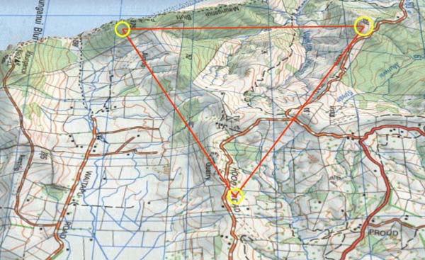
Figure 5: An isometric view of a giant equilateral triangle of 11520 feet per side, extending from the southern hubstone of the Waitapu standing stone circle observatory, situated near the seaward cliff, to the purpose built tor mound beside Hood Road. From there the triangle extends to a large and conspicuous buttress of rock situated high up on Puketapu Hill and resolves upon a line of boulder markers near the buttress. Also adjacent to the rock buttress, in the saddle of the hill near the summit, are several ancient cairn boulder heaps, one of which marks the ancient league from a station on the southern ridge of the Waitapu Valley.
Puketapu Hill is the location of a large cairn observatory, which is situated on its lower NW plateau, as well as a yet lower standing stone site dedicated to alignments between Maunganui Bluff and northern mountains.
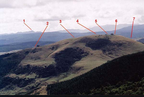
Figure 6: Puketapu hill, which was once a major centre of astronomical and land mapping endeavours. The hill has many cairn and standing stone markers orientating out to the 4-points of the compass. (Photo by Brendon).
1. This mountain peak is on the northern side of the Hokianga Harbour (Pungaru) and is the most targeted northern mountain from many marked alignments of the Maunganui Bluff region.
2. This lower plateau site at Puketapu hill has a huge hubstone boulder sitting as an interim position between the northern mountain and the central summit of Maunganui Bluff. The plateau has several peripheral cairn and standing stone markers, which clearly indicate alignments toward identifiable distant locations by the manner in which outlying markers relate back to the huge, central hubstone.
3. This is the plateau that has a large cairn observatory spread over it. Based upon a partial, compass survey undertaken in 1997 we drew the positions of some 150 cairns, but estimate the number to be in excess of 200. The cairn markers are set out symmetrically.
4. This is the summit of the hill and has 8 sighting pits (some now faint) which orientate toward Maunganui Bluff and a high seaward hill on the northern side of the Waitapu Valley.
5. In the slight saddle depression of the hill are a cluster of cairns and some boulder markers. This area was a junction for overland alignments.
6. The huge buttress rock measuring about 12 feet square and visible for many miles. Its position high on the hill made it an obligatory marker. Very near to it on the summit is the boulder line, which marks the intersection of the 11520 feet per side equilateral triangle. The line of boulders redirects the triangle intersection toward the southern hubstone of the Waitapu Observatory.
7. Down the ESE face are a number of cairns that face in the direction of the tor mound hump of the Waitapu Valley's northern ridge. Although GPS fixes are yet to be completed on their positions, one of these cairn markers, undoubtedly resides at 12960 feet from and due north of the benchmark cleft on the Waitapu Valley's sea cliff. This number relates to the precession of the equinoxes (½ value), which was anciently set at 25920-years. It is also a number much used in ancient navigational mathematics, wherein on the circumference of a circle generated by one league of diameter, 12960 feet was 90-degrees of arc or one quadrant. Another marker will, predictably, relate to a position 11520 feet due north of the Waitapu Observatory's southern hubstone.
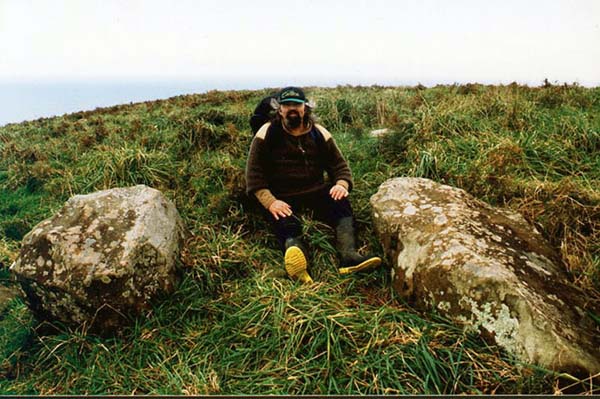
Figure 7: The author sitting between the southern hubstone (left) of the Waitapu standing stone observatory and an important sight over stone (right). Several hundred large or largish marker stones are associated with this dual hubstone circle observatory. The component stones of the site range from over 6 feet tall sharksfin shaped stones down to 6-inch diameter. These smallest markers, with tops protruding above ground, are solidly housed into the terrain and are of unknown length. The southern hubstone sits 11520 feet from marked positions on Puketapu hill. One of these positions is toward the summit and is part of a giant equilateral triangle linking Puketapu to the tor mound on the northern ridge of Waitapu valley, as well as the southern hubstone. The line from the hubstone to the tor mound is based upon a Khafre Pyramid lunar code (59.0625-degrees), making the alignment to Puketapu 359.0625-degrees. Another due north expression of 11520 feet will extend from the southern hubstone to a marker on Puketapu's ESE face near to but east of the large buttress outcrop. The Tasman Sea is visible in the background. (Photo by Brendon).
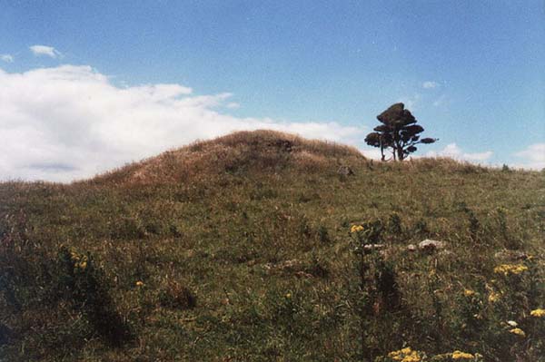
Figure 8: The tor mound jutting up conspicuously like a pimple on the northern ridge line of the Waitapu Valley. This is one of several tor mounds in the immediate vicinity, which were carefully positioned as primary trig positions. The sky-line plateau upon which it sits has many cairn positions placed upon it and one can be partially seen in the foreground. The tor sits 11520 feet from both the southern hubstone of the Waitapu Observatory and a boulder marker stone atop Puketapu Hill in a perfect equilateral triangle with 3 stations 120-degrees opposed. The lines of precise length and known degree angle, extending between these 3 stations were surveyors baselines and from the ends of each line degree angle, distance and elevation calculations could be made related to the precise overland positions of any visible mountain peaks or points of interest. Unfortunately a bulldozer has cut a swathe of structure off the southern end of the tor, but its original dimensions are still clearly evident.