Having assessed the coded angles and distances from either the benchmark cleft
on the seaward cliff or the southern ridge tor mound…to the northern ridge
tor, let's now discuss a series of codes extending from the Waitapu Observatory
region to the southern ridge tor. At least one hubstone of the observatory represents
a coded angle and distance position from the tor and the same holds true of
a series of rising trigs or plateau trigs sitting just slightly north of the
observatory.
Although it was not possible, in every instance, for the ancient surveyors to
achieve coded angles on each closely situated rising trig, it was possible to
code a special distance value that had to be encrypted for eternal mnemonic
recall.
The distance from the southwestern edge marker of the southern ridge tor mound
to the northern hubstone of the Waitapu Observatory was intended to code 2160
Egyptian double Royal Cubits of 3.456 feet each at an azimuth angle of 283.5-degrees.
The moon is 2160 miles in diameter and the perimeter measurement of the Khafre
Pyramid (Egypt's Pyramid of the Moon) is 2835 feet. The Pyramid of the Sun at
Teotihuacan is said by Harleston to be 216 Hunabs long and his estimation of
a Hunab length falls very close to an Egyptian double Royal Cubit of 3.456 feet.
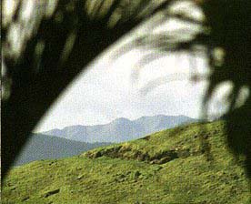
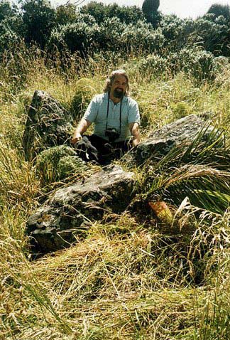
Figure 1: The red ellipse shows the location of the Waitapu Observatory near the frontal sea cliffs. Adjacent to and north of it on the steeply rising hill are a series of trig boulders in a line. At the top of the hill rise is a flat plateau with a series of trigs placed upon it. Many positions in this area relate directly to the tor mound on Maunganui Bluff's lower ridge in both coded distances and angles.
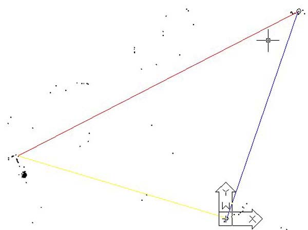
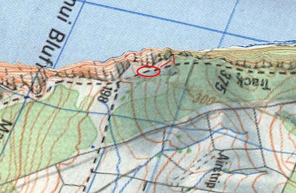
Figure 2: This picture from AutoCAD shows some of the cairn markers, standing
stones, tor mounds or observatory sites within the Waitapu Valley or near vicinity.
The "ink blotch" mark to the lower left side of the picture is the
Waitapu Standing Stone Observatory. The 90-degrees opposed X,Y arrows mark the
position of the southern ridge tor mound and the blue and red line intersection
is on the northern ridge tor. To give some idea of the distances depicted, the
red hypotenuse line is just over 2-miles long. So what does this giant triangle
mean?
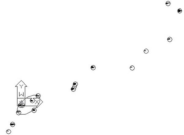
Figure 3: This picture from AutoCAD shows the southern ridge tor mound and nearby cairn or large boulder markers that extend out along the southern ridge. Conveniently, these face the opposing markers some 8000 feet away NW on the sea cliff plateau above the Waitapu Observatory. The southern ridge tor mound markers relate to the distant sea cliff plateau markers in coded distances, as well as a few coded angles where achievable.
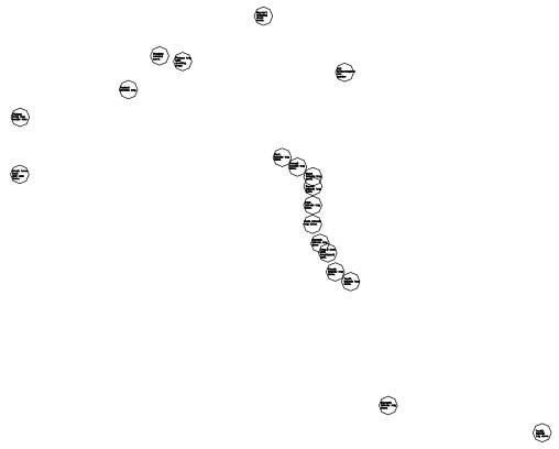
Figure 4: The distribution of structures on or adjacent to the sea cliff plateau, as ascertained by GPS fixes. The upper structures are situated either directly on top of the flat plateau or to each end of it, with one extreme western stone circle position sitting at a lower level, but still fully visible from the southern ridge tor mound. The topmost marker shown in this picture is a fully-fledged "standing stone circle" situated amidst trees and thick overgrowth. Raywin Cook first discovered it in 1997 and we've dubbed it "Raywin's Circle" accordingly. The lower right "snake" of circles indicates the epicentre positions of a series of downhill trig boulders in the very long grass and bracken. These are mostly multi-component circles in their own right, each with peripheral markers and a large central hubstone.
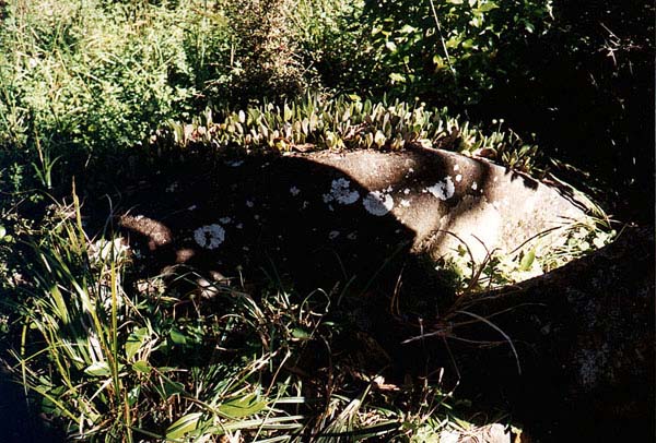
Figure 5: A tumbled boulder of Raywin's circle, cloaked in moss and lying amongst the surrounding trees. No attempt has yet been made to survey the positions of the fallen stones, but the evidence seems to suggest that Raywin's circle was a small observatory in its own right.
Rather than try to identify each and every code between the two sets of markers some 8000 feet removed from each other a limited cross section of the more apparent and obvious coded positions will be dealt with. This should be sufficient to acquaint the reader with the fact that there is something very dynamic happening and show that the accumulation of distances or, in some cases, angles are there by design and not by chance.
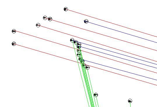
Figure 6: This picture shows a sampling of very probable length codes running to trig markers on the top plateau and hillside above the Waitapu Observatory. The red and blue lines extend for about 8000 feet from markers on the southern ridge tor mound or an adjacent cairn situated beside and southwest of the tor. The green lines all originate from the benchmark cleft on the southern valley seaward cliff. Because the cut cleft horizontal ridge is about 50 feet in overall length east-west it's a little indefinite as to which end the ancient surveyors were using as the trig point. Evidence seems to suggest it was the inner or eastern end, as that point has the effect of making the level trig across the valley sit at an azimuth angle of 345.6-degrees.
As has been stated, there are many layers of coding going on within
the Waitapu Valley and it is the purpose of this series of articles to simply
alert the New Zealand public or overseas researchers about what's there.
I could devote my time to expressing an opinion related to the mathematical
purpose behind every position, but, by so doing, this study would get oppressively
boring very quickly to the average reader. As it is, trying to get people to
gain archaeological and historical insights by making them wade through droves
of numbers in akin to "mission impossible"…nevertheless, there
is no other, less painful way to do this, as the ancient people were heavily
involved in coding their special "numbers of civilisation" into the
landscape such that the irretrievable knowledge would never be lost or forgotten
in any generation.
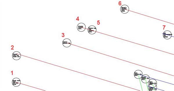
Figure 7: A cairn sitting to the southwestern edge of the southern ridge tor mound about 8000 feet away provides length codes for positions 1, 2 & 3. A large marker on the summit hump of the tor mound provides the coded length 4 and the codes for 6 & 7 extend from the stone circle marker on the front of the tor mound.
1. This distance is coding 8090.1695 feet or 3000 true Megalithic Yards (32.360678 inches) based upon the PHI ratio. This length is also 1200 Megalithic Rods of 80.901695 British Standard inches. Professor Alexander Thom first postulated the idea of a Megalithic Rod measurement, based upon a recurring, approximate increment that he encountered on British standing stone observatory sites.
2. This distance is coding 8100 feet, which is 3000 "rounded" Megalithic Yards of 32.4 inches each. A numerical progression based upon 20.25, 40.5 & 81 or 16.2 & 32.4 was very effective in following the progress of the moon during the 7.2 lunar years (2551.5-days) within the 7 solar year Sabbatical Calendar system. It's significant that "true" and "rounded" Megalithic Yard distances were similarly coded side by side at Carnac, France in the two most extreme eastern components as they related to the centre hubstone of the western circle.
3. This distance is 8000 feet from the cairn marker adjacent to the southern ridge tor.
4. This distance is 8000 feet from the top of the tor mound.
5. This distance is 2953.125 rounded Megalithic Yards or 7973.4375 feet from the top of the tor mound. The MY distance is in homage to the lunar month, which is 29.53125-days. This extremely important marker also relates as an alignment trig to a distant mountain in the "V" (the declining end of close by Maunganui Bluff and the more distant declining end of the Tutamoe Range).
 |
|
6. This coded length runs from the big circular marker on the front face of the southern ridge tor for 7920 feet to "Raywin's Circle". This appears to be a fully-fledged observatory that lies amidst tree growth and thicket, which makes it difficult to assess. The 7920 feet distance is in homage to the 7920 league circumference or the 7920 mile diameter of the Earth under the Egyptian "11" series geodetic system. The Earth is, quite literally, 7920 miles wide equatorially.
7. This distance has already been mentioned as 7854 feet (coding ¼ PI) and running from the top of the southern ridge tor.
There are several more cairn markers associated with the southern ridge tor, which also relate to positions on this frontal sea cliff plateau, but we'll skip those at this point in time.
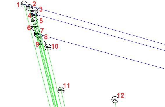
Figure 8: The hillside trig boulder positions, as fixed during a GPS survey
of the Waitapu Valley. The sample blue lines represent distances from the tor
mound on the southern ridge, whereas the green lines originate at the benchmark
cleft on the sea cliff at the southern side of the valley. This region of the
site is one area where the trig positions could have been severely affected
because of the steepness of the terrain. Most hubstones are of the flatter sharksfin
shape and the likelihood is that they've simply been tumbled very close to their
original positions.
1. This position appears to code 880 true Megalithic Yards or 2373.1164 feet
from the benchmark cleft. It also sits 7854 feet (coding ¼ PI @ .7854)
and at an azimuth angle of 286-degrees from the boulder marker on the top of
the southern ridge tor. In "rounded" MY, the distance from the benchmark
cleft southward would be 2376 feet or 432 fathoms (of 5.5 feet each…ancient
length). The Great Pyramid was 432 Hebrew/ Celtic Royal Cubits (21 inches) in
length. The distance of 2376 feet also translates to 687.5 Aztec Hunabs/ Egyptian
double Royal Cubits of 3.456 feet each. The 68.75 mathematical progression was
very important in the "11" series geodetic system and 6.875 inches
would be ¼ of the length of an Egyptian "11" series Royal Cubit
(20.625 inches…used for calculating and remembering the size of the Earth
in leagues). The distance of 68.75 miles was 1-degree of Earth circumference
arc under that system. The distance of 2376 feet also equals 1375 Egyptian Royal
Cubits of 20.736 inches.
2. This position is coding 28350 inches (2362.5 feet) from the benchmark cleft. This is a very important lunar code progression associated with the Khafre Pyramid (Egypt's Pyramid of the moon). The height of the Khafre Pyramid was 472.5 feet (based upon a 3,4,5 the triangulation or squaring method) and this is 236.25 feet X 2. In other words, this marked valley distance is 5 times the design height of the Khafre Pyramid. The perimeter value of the Khafre Pyramid is 2835 feet and this distance is 28350 inches or 270 reeds of 10.5 feet each. The sum of 2363.5 days would be 80 lunar months. This "cross valley" distance would also be 1375 Egyptian sexagesimal Royal Cubits of 20.61818182 inches each. The 1375 number was used in an 11 series mathematical progression and has now occurred in both positions 1 & 2.
3. The third hillside trig down doesn't appear to have much meaning and might have been a peripheral marker for the hub above or below. Alternatively, it might have been severely jostled and tumbled, thus obscuring its purpose. Some of the peripheral markers are large stones and all sit within very tall grass or bracken, making it difficult to determine where one trig circle commences and ends. It would seem, in this instance, that we've taken a GPS reading on an outer ring stone.
4. The fourth trig down is 2333.3333 feet from the benchmark cleft. This is 1/3rd of 7000 feet. It was very common under the ancient system of numerical values to render numbers in this way for easy manipulation. The trig was obviously coded to sit 7812.5 feet from the boulder marker atop the southern ridge tor mound, as this was a very important ratio/ progression in the Egyptian "11" series geodetic system. Although we'll not pursue the matter at this time, the summit of the distant tor with its several ruined summit markers was ideally situated to provide several more coded lengths and angles to these hillside trig positions. One obligatory angle back to the tor would have been 105-degrees.
5. The fifth trig down is a little more complex to get ones head around. I relates to the fact that the pre-dynastic Egyptians and others often worked to 7th values in the 360-degree system. These show up quite dramatically in two of the Station Stones azimuth angles at Stonehenge, which are set to 115.7142857-degrees and (180-degrees opposed) 295.7142857-degrees. These numbers are not really as complicated as they look and simply indicate whole numbers and fractions in 7th values. There were two primary circle systems that ran simultaneously…one based upon 6 and one based upon 7. The 360-degree system could be ratio increased by 1.75 to be 630-degrees and then work fluidly to a "7" or "70" based system rather than "6" or "60" based system.
The seemingly difficult Stonehenge value of 115.7142857, when subjected to a ratio increase of 1.75 becomes 202.5-degrees in a 630-degree system. The 202.5-degree increment thus generated was related to counting lunar periods within the 7.2 lunar years/ 7 solar years Sabbatical Calendar system. Under that system it was convenient to break up the 2551.5-days (7.2 lunar years) into simple whole day periods or into whole days and quarter day periods, etc. The count worked well to 20¼ days (20.25), 40½ days (40.5) or 81 whole days. At Waitapu Valley, the coded distance from the benchmark cleft to this trig appears strongly to be 2314.285714 feet or 2 X 1157.142857 feet. The distance is positively coding twice 1157.142857 and is related to the "Station Stone" azimuth position at Stonehenge, which was 1/20th of this Waitapu Valley value.
The 90-degrees opposed Station Stones azimuth angles at Stonehenge were 162-degrees and 342-degrees respectively. The "162" aspect co-relates with the 20.25, 40.5, 81, 162-day lunar count within the 2551.5-day Sabbatical system. The count of 2551.5-days (7.2 lunar years) or 2556.75-days (7 solar years) could each be calculated in increments of 5.25-days on a "reed" measuring rod (10.5 feet). The staffs carried by most ancient priests were probably in half reeds of 5.25 feet. This researcher regrets the involved nature of the explanation, but asks the reader to consider that preserving knowledge of the interrelating lunar and solar cycles was fraught with difficulty. A very sophisticated system had been passed down from generation to generation and had to be positively preserved in the positions of enduring stone.
6. The sixth trig down is, mercifully, easy to explain. The distance from the benchmark cleft is 2304 feet or 1152 feet X 2. The 1152, 2304 progression is one of the most used and valuable in antiquity and relates to everything from correcting the Sothic year from 365.25-days to 365.2420-days and onward to incremental values within navigation. The "flat topped" Great Pyramid is 230400 square feet per face (8 Egyptian or Pyramid acres…according to Herodotus).
7. Again, it looks like we mistook a peripheral boulder for a trig during our GPS fixes, as the position doesn't appear to have any great significance.
8. The eighth trig is very significant both in its relationship to the southern ridge tor mound and the sea cliff benchmark cleft. It sits 7776 feet from the tor and 2268 feet from the benchmark. The 7776 feet aspect is reminiscent of a special distance linking the circular and octagonal earthbank components of the Octagon of Newark, Ohio. The centre-to-centre position of each is 1555.2 feet or 576 "rounded" Megalithic Yards of 32.4 inches. The distance of 7776 feet at the Waitapu Valley (2880 rounded MY) is 15552 feet ÷ 2, or 5 times the Octagon's centre-to-centre distance. This number was used copiously within the Octagon and 2 of the 8 embankments sit on azimuth angles related to a mathematical progression that includes 15552 (NW embankment…38.88-degrees & NNW 64.8-degrees). At the Octagon the azimuth angle that the site lies on is 51.84 degrees (1/30th of 1555.2). The progression simultaneously accentuates 1.62 (rounded PHI) and 25.92 (numerical value related to the precession of the equinoxes or navigation based on "11" series linear distances and sexagesimal circumference (angle readings). This distance of 7776 feet across the Waitapu Valley would be 16800th of the "ring of the Earth" under the sexagesimal geodetic system.
The significance of the 2268 feet distance (lunar code) has already been explained related to this position. This number of days is 1/3rd of the 6804-day lunar nutation cycle and this exact distance represents 3 base perimeter side values of the Great Pyramid. Likewise, 2268 X 2 = 4536 and the sexagesimal height assignment of the Great Pyramid to the top of its altar floor was 453.6, which is 1.6666666 less than the pyramid's side length (756 feet). Not surprisingly, the benchmark cleft would have been situated on an azimuth angle of 166.66666-degrees from a trig slightly further down the hill from this one (trig 10). The 1.6666666 ratio was much used in antiquity and derives from a basic rule within all 3,4,5 triangles wherein one side will always be 1.666666 less than the hypotenuse in length. This same rule was applied to the height of the "flat topped" Great Pyramid in comparison to its length.
9. The ninth trig codes another easy and highly recognisable value. It sits 2240 feet from the benchmark cleft and was once a major incremental value in what later became the British Weights Standard (2240 lbs in a ton). The perimeter value of the Great Pyramid is 22.4 X 135 = 3024 feet. The British system used 16 oz or 7000 grains in a pound, 14 pounds in a stone, 112 pounds in a hundredweight (cwt) and 20 cwt in a ton. All of these values are fluidly divisible within the base perimeter length of the Great Pyramid. The British Weights system came from Egypt to Europe as early as 5000 BC and similar values as these Waitapu Valley lengths (like 2240 feet) are encoded into the standing menhir positions at Carnac, France.
The British pound weight is exactly the same as the Egyptian Sep. According to the Encyclopaedia Britannica (15th Edition) article devoted to ancient Weights and Measures, some 3400 weights have been recovered from archaeological digs in Egypt/ Nubia. Although there are many combinations of weights in various progressions of numbers, the basic Egyptian unit appears to be a "Kite", equating to .16 British Standard ounces. Ten "Kite" make one "Deben", equivalent to a British Standard ounce and 10 Deben make one "Sep" (7000 grains), which equals 1 British Standard pound (7000 grains). It can be demonstrated that the weights, measures and volume systems of all of the great civilisations, trading from early epochs to late eras in and beyond the Mediterranean, stem from the same universal system. Traders needed only to use simple ratios to convert regional currencies, volumes or weights into a foreign, localised standard. All regional standards in common usage were simply ratio expressions of an earlier universal standard originating with the pyramid builders (long before the Egyptian Dynastic period).
10. The tenth trig was configured to be 825 rounded Megalithic Yards of 32.4 inches each (2227.5 feet). The Great Pyramid is 1120 increments of 32.4 inches in perimeter value and it would seem that our British Standard hundredweight (112 lbs) derives from that. The 2227.5 feet distance is also 405 ancient fathoms of 5.5 feet each or 68.75 increments of 32.4 feet (12 rounded MY). The distance appears to have been used to remember ratios like 8.25 (navigation by the "11" series league system), 40.5 (lunar day-count under the Sabbatical Calendar system), 68.75 (1-degree of arc in miles under the "11" series geodetic system), 1.62 (rounded PHI), 32.4 (rounded MY) and 5.5 (ancient fathom), etc.
The Menkaure Pyramid was 356.4 feet per side under its fathom assignment (22.275 feet X 16). It was also exactly twice the diameter of "Y" Holes at Stonehenge under its pure PHI assignment (355.987597 feet) @ 132 pure MY per side.
Although we'll not try to "fathom" the deeper meanings behind these numbers in this article, rest assured that the full mathematical system was very profound, with many simultaneous layers of meaning. These layers were being carefully encrypted for mnemonic recall into the positions of the Waitapu Valley. The stone positions were never anything more than memory or teaching devices to help Masters of the Craft and their initiates remember the parcel of sacred numbers that were used for maintaining the concept of civilisation and optimised society. The greater precisions or refinements of the numbers reposed at all times within the minds (or on the quippu/ kupu string knot memory devices) of adept masters, whose responsibility it was to keep the knowledge alive and intact for ensuing generations.
11. The 11th trig was undoubtedly coding 2100 feet or 1200 Hebrew/ Celtic Royal Cubits (of 21 inches), which was, earlier, an Egyptian measurement found in the dimensions of the Great Pyramid. This distance would also have been 1400 common Hebrew/ Celtic cubits of 18 inches each. Another Hebrew measurement of 17.5 inches (1440) is also inferred, as is the measurement that later became the Roman foot, which was 11.666666 inches. There would be 2160 Roman feet in this length. The 2160 Roman feet (which Roman increment also originated in Egypt) is in homage to the 2160 years that the sun lives in one house of the zodiac during the precession of the equinoxes (12 houses…25920 years total for the cycle of precession). The 2160 value also relates to the diameter of the moon (2160 miles). The fact that the Romans had a measurement of 11.666666 inches shows that they also used a standard measurement of 10 inches.
All Royal Cubits in use in various ancient countries had a common cubit companion. The formula for finding the "common" measure was to divide the "Royal" by 1.16666666. Thus the Hebrew/ Celtic 21 inch Royal becomes 18 inches, the Egyptian sexagesimal Royal Cubit of 20.61818182 inches becomes 17.6727272 inches and the Roman foot of 11.666666 inches becomes 10 inches. Another large measurement encountered in Egypt was 25 inches. It seemingly had a 1.16666666 increased Royal companion @ 29.1666666 inches. When the 36288 inch perimeter of the Great Pyramid is divided by 29.1666666 inches, then the answer is 1244.16. This is ½ of 2488.32… the number used to describe the circumference of the Earth under the Egyptian "true" size geodetic system (24883.2 miles… based upon the Egyptian 1.728 feet, half Aztec Hunab Cubit). Our present day figure is about 19 miles more. The 25 inch increment would have been used in reference to the Great Pyramids "11" series assignment, which saw its perimeter value as 3025 feet. There would be 1452 increments of 25 inches in 3025 feet and 1/1452nd of the Earth's circumference, under the "11" series system = 90000. Similarly, the Khafre Pyramid would have complied to 1360.8 of these large cubits (2835 feet perimeter) and half of 1360.8 is 680.4…the number of days in the lunar nutation cycle was 6804.
A Hebrew measure of 17.5 inches would have had a companion of 15 inches (both measures a 1.5 ratio increase on the Roman foot of 11.666666 inches and its lesser, associated 10-inch companion measure). The above partial explanation can be applied to all reasonably identifiable standard measures, volumes, weights and currency values (precious metal coin weights) of antiquity in the Mediterranean and Atlantic, wherein each nation's standards were related by ratio values…which was the only way trade that could take place between the Great Civilisations.
12. This trig sits 2025 from the benchmark cleft and this value accentuates the mathematical progression used to monitor the progress of the moon during the 7.2 lunar years (2551.5-days) period within the lunisolar Sabbatical Calendar system…20.25, 40.5, 81, 162-days, etc.
A Large amount of additional analysis could be offered related to this western end of the Waitapu Valley. The prime objective is to demonstrate that the positioning of structures was for a prescribed purpose and to identify, as close as possible, what that purpose was.
Historians and archaeologists often put forward implausible explanations as to why ancient builders erected the massive structures of antiquity or undertook to complete ambitious and difficult projects. One bastion explanation for the unexplainable is that "such and such" was done solely for "religious or ceremonial" purposes. The giant Octagon complex of Newark, Ohio or associated massive geometric earthworks nearby, are said to have been little more than "dance grounds". We're offered fantasy accounts of how "it must have been splendid" watching the flowing plumed, brightly costumed native-Americans decked out in all of their ceremonial regalia, dancing and chanting within their purpose built ceremonial complex…a truly lovely, colourful spectacle. This might have been a function that late era native-Americans used the Octagon for, but who built it in the first place and for what?
It doesn't seem to matter that the geometric perfection of the Octagon complex lends itself admirably to very accurate lunar determinations, as well as mnemonic recall of the sacred parcel of values used in the maintenance of civilisation from Egypt to Oceania. It was built, we're told, for dancing…and there was a real "song and dance" from the "Mound Builder's Country Club" golfing administration recently when 73-year old Cherokee, Barbara Crandell, turned up there to say prayers, which necessitated arresting her and leading her away in handcuffs.
The "ceremonial or religious" explanations, don't work on dedicated
researchers anymore. Such simplistic, shallow reasoning is insufficient to satisfy
the rational mind as to why there was laborious endeavour, on such a grand scale,
undertaken in antiquity.
Invariably, the true reason why these enigmatic structures were built was to
preserve "high civilisation" and an optimised way of life, based upon
the best possible information extractible and foresight scientifically attainable: