SPLIT-APPLE ROCK, AN ANCIENT, PURPOSE BUILT SOLAR OBSERVATORY.
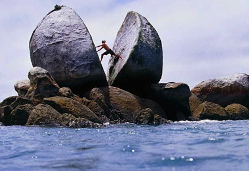
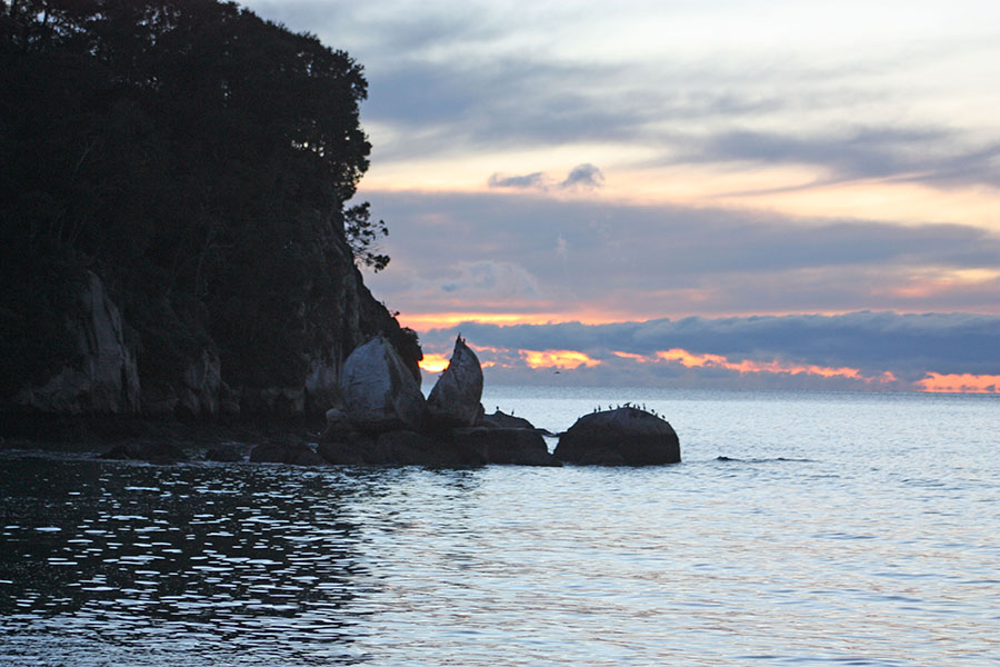
On the northern coastline of New Zealand’s South Island is a geological wonder that is world renown, traditionally called Split-Apple Rock due to its appearance as a giant sliced-in-two apple.
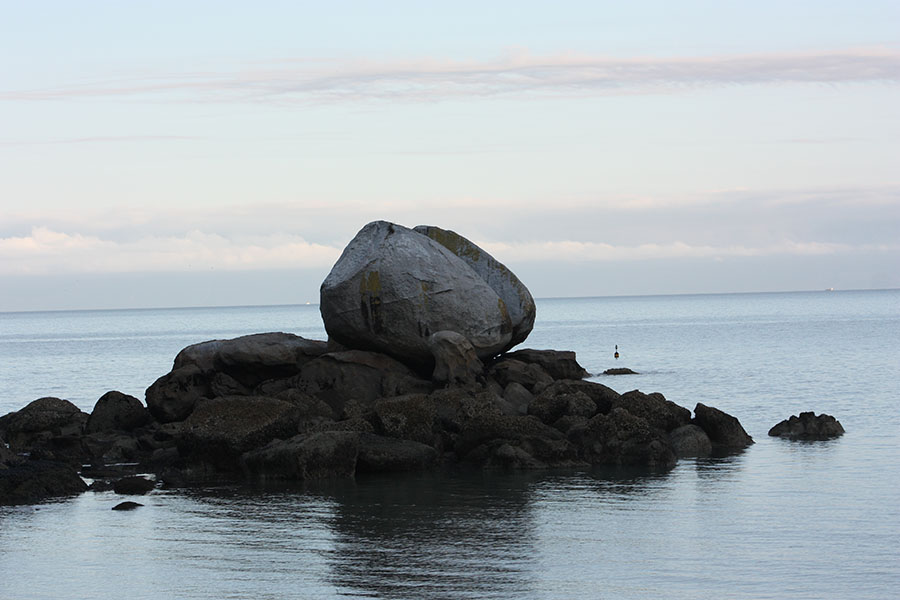
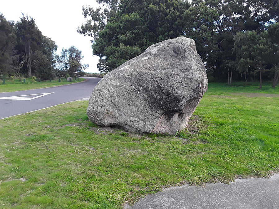
The giant boulder, given its height and fairly symmetrical round shape of about 18-feet in diameter, could weigh as much as 238 imperial tons (242 metric tonnes).
It appears to sit on a boulder pile composed of similarly high quality, hard granite components, whereas the general material of the surrounding area is of a softer or more-flaky composition, totally unlike the split-apple boulder or the platform boulders upon which it is cradled and housed.
The evidence suggests very strongly that this is not a natural geological stack, but a purpose built one to serve an important astronomical and calendar function.
A stock photo from the Internet shows just how immense this granite boulder actually is. Remarkably, there appear to be little or no similar examples of large, dense granite boulders strewn about anywhere within view, as one would reasonably expect to find.
The general terrain of the area is predominantly a composite rock, made up of many varying elements. It is semi-hard and durable but quite crumbly under pressure and could never be used for making stone blocks. Whereas the incredibly hard granite found on the split-apple boulder was formed from molten magma under tremendous pressure far beneath the Earth’s crust, the immediate-vicinity, local terrain is seemingly devoid of any known deposits of similar material.
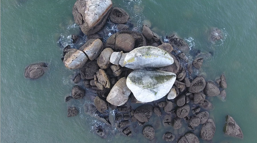
The giant split boulder sits on a boulder pile platform-island that does not appear to be a natural rock up-thrust, but more like a purpose built, piled-up structure of high quality, durable support boulders. The giant Split-Apple also seems to be locked into position by chock boulders to underpin, cradle and stabilise the two giant halves firmly into a set position and orientation.
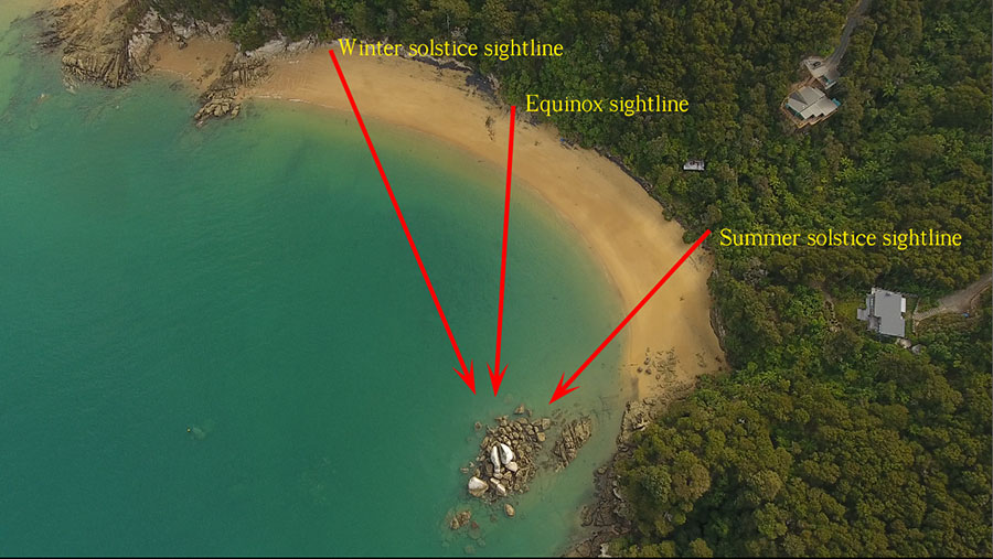
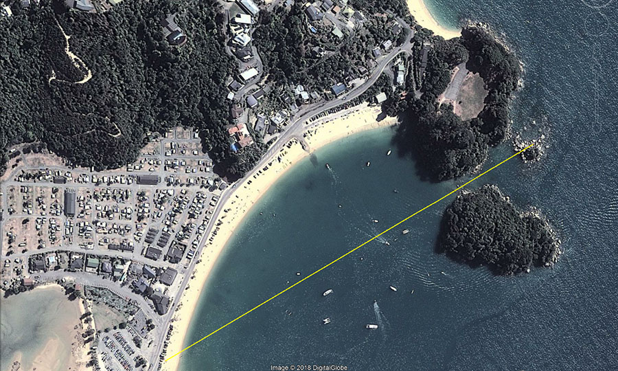
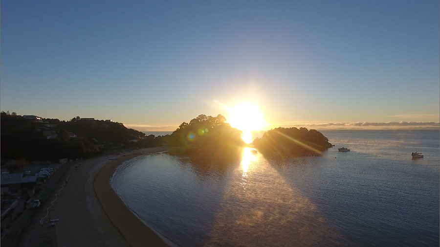
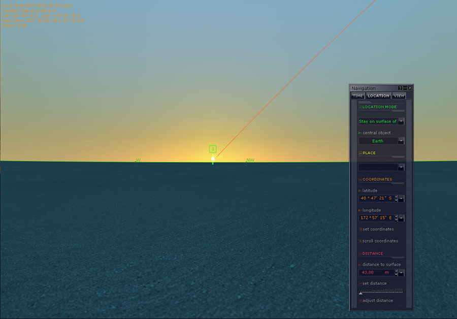
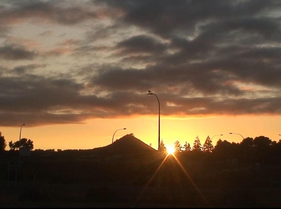
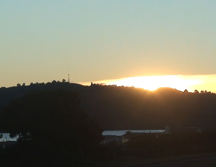
The split boulder forms a gun sight-type “V” that points accurately at the vertical, lower edge of the sea-cliff 330-feet away (100 metres), at an angle approaching 59.5-60 degrees azimuth.
From the beach viewing position, one visually aligns the base of the split-apple “V” with the vertical edge of the cliff to form an accurate alignment onto the winter solstice, first-glint sunrise position. The sun, rising on a slight diagonal to the left (North), then climbs the edge of the cliff to launch itself into the sky from the cliff top. From the position of observation at beach level the sea horizon conjuncts perfectly with the base of the “V” and first-glint of the sun occurs low in the “V”.
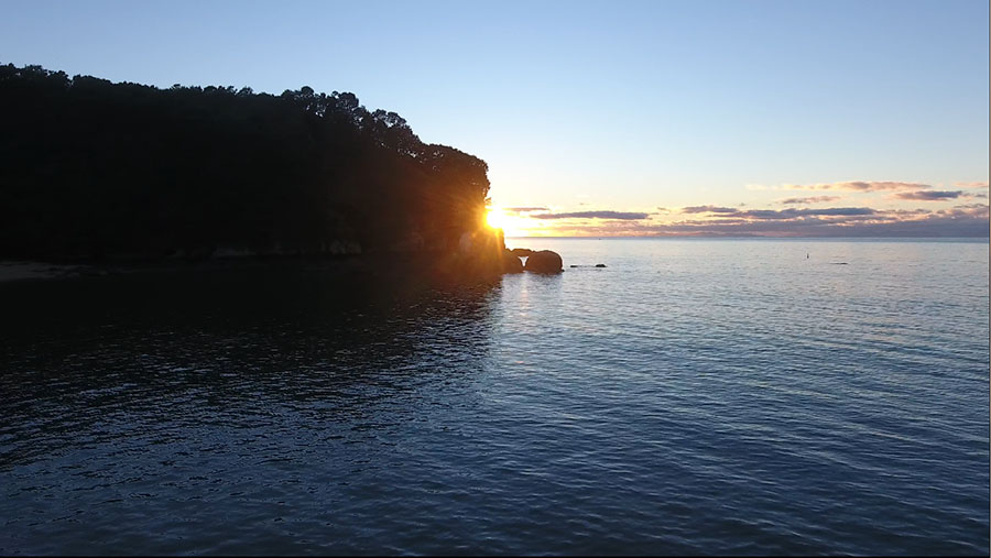
The winter solstice sun climbing the cliff edge. The first-glint position seen at the base of the “V” represents the most northerly position the rising sun will move to in its annual journey up and down the eastern sea horizon and distant land-masses.
SPLIT-APPLE ROCK ALSO WORKS PERFECTLY FOR DETERMINING THE EQUINOX SUNRISES
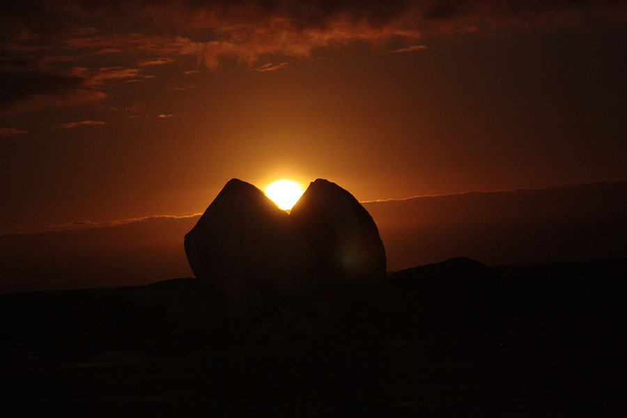
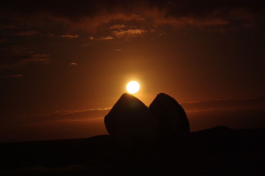
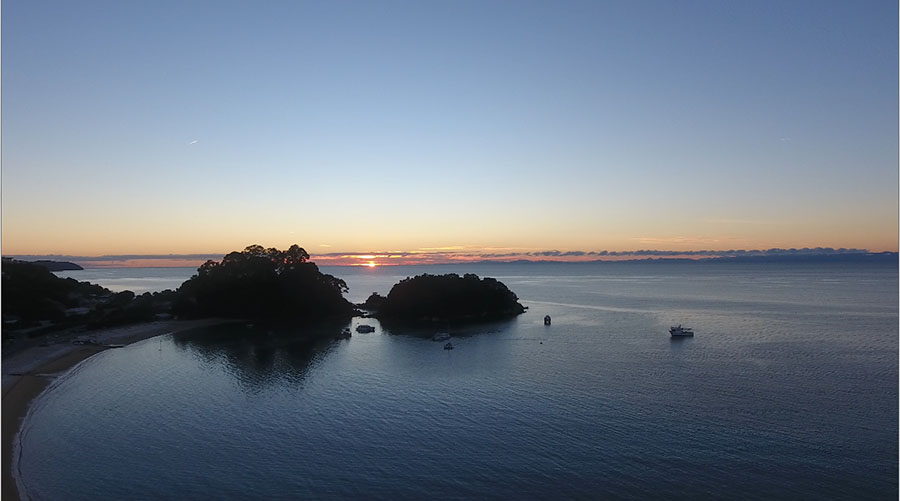
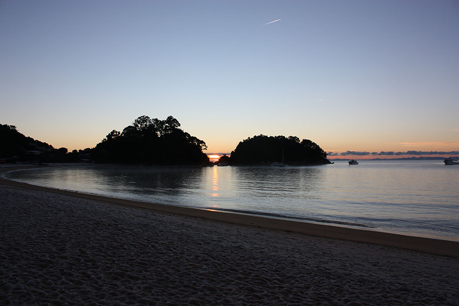
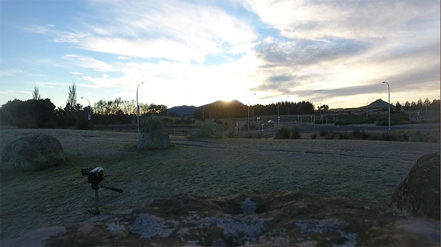
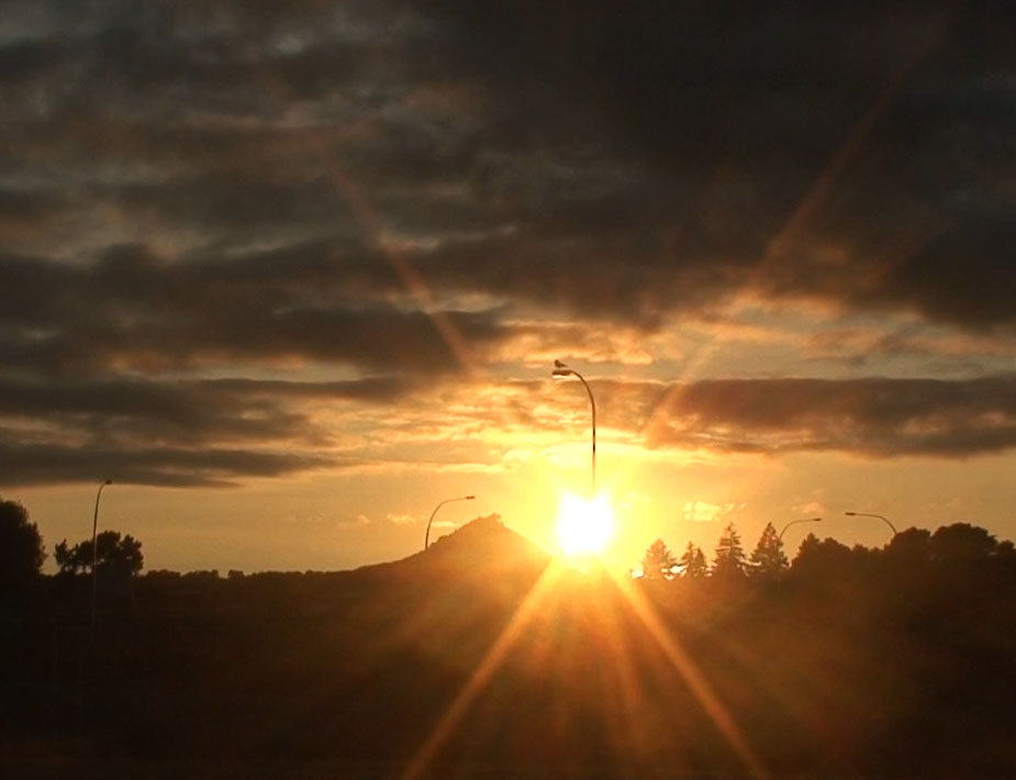
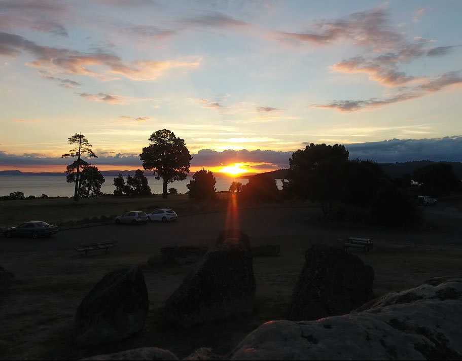
Whereas the sun rises at 59.5-60 degrees azimuth at the time of the Winter Solstice, at the Autumnal (March 21st) and Vernal (September 21st) equinoxes it rises at 90-degrees. To accurately witness the two annual equinox events through the Split-Apple "V" one moves to a more westerly position of the beach. By viewing through the "V" to ranges across the sea situated at 90-degrees azimuth, the exact day of the equinox can be accurately fixed.
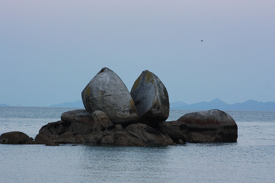
At this point of the beach viewing position the "V" in Split-Apple Rock is half diminished in depth, but still highly visible and exploitable for cradling the equinoctial sun's orb. In the much magnified background is seen the distant range across the water, where the sun rises from a peak 1800-feet high (550 metres).
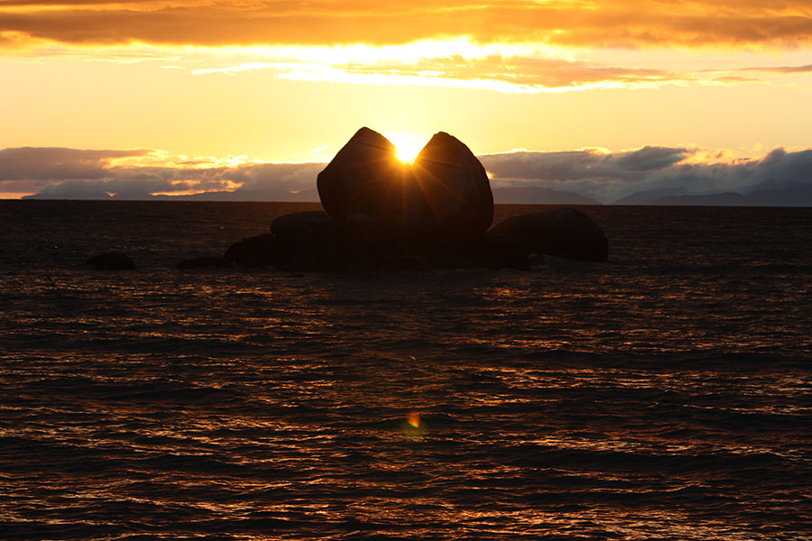
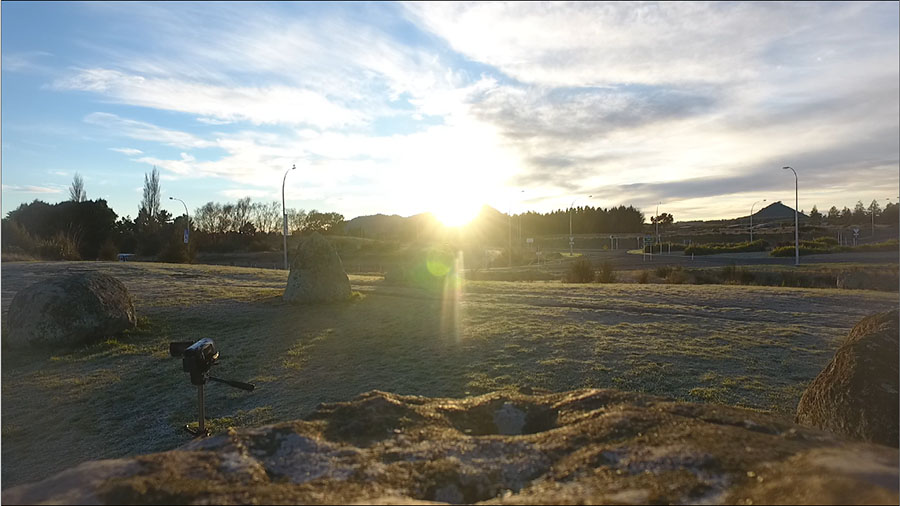
The equinoctial sun cradled in the base of the "V" after rising from behind the distant range. It then moves upwards into the morning sky on a slight diagonal to the north.
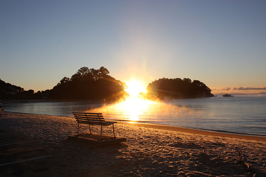
It is very apparent that Split-Apple Rock works perfectly as a solar observatory for both the winter Solstice and equinoxes. It would also work fine for the summer solstice sunrise (120-degrees) fix as well, although the "V" would be much diminished and represented only by a small trough in the crown of the boulder, as seen from the observer's position on the beach.
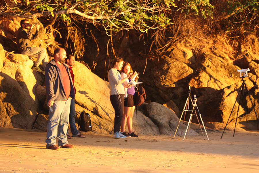
French, Italian and New Zealand observers watch the equinoctial sun's orb rise from the Split-Apple "V", with cameras rolling to record the event.
THE SUPERMOON RISE AT THE EQUINOX
On the occasion of the 2019 autumn equinox for the Southern Hemisphere a super moon rose almost exactly on the equinox line. This was a rare event not to be missed.
On the evening of the equinox the super moon rose through the "V" of the Split-Apple very close to the solar equinox rise position and is seen here cradled in the "V".
The super moon of the 2019 equinox ascending upwards to the north to break free of the Split-Apple "V".
This extreme northern position along the shoreline is where one would need to be in order to observe the summer solstice for the Southern Hemisphere, using Split-Apple Rock as the outer marker. The "V" aspect of the boulder is much-diminished to only a concave trough, but would be sufficient for a finite fix on the sunrise. Alternatively, the right-hand base of the boulder could be used to capture "first-glint" of the sun on the horizon, followed by its diagonal climb up the edge of the boulder to the trough position.
On this line of sight, just above the beach, is a wide assembly flat-area where ancient people could once have gathered for their summer solstice festivities. That expansive piece of terrain has not been subjected to modern-day machine modifications, as there would be no access due to steep hills behind.
These are the 3 positions along the beach where ancient astronomer-priests would stand to witness the significant, annual solar days using the Split-Apple outer-marker, and, thus, have the ability to keep their 365.25-day calendars completely correct.
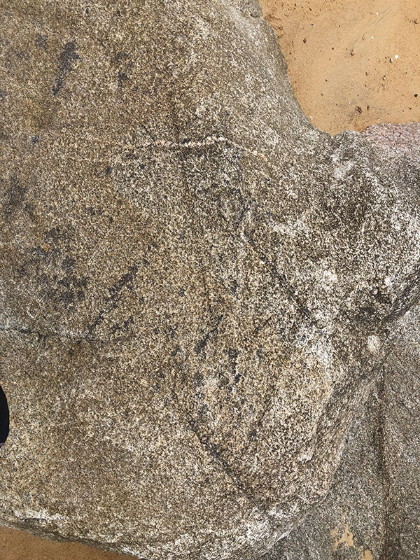
It seems obligatory that ancient savants would have marked the beach sighting positions with boulders or post markers, but centuries of storms and surging seas have now eradicated those positions. There is however one incised bolder left on the old track near the assembly area for the summer solstice.

This ancient wayside track marker near the assembly plateau has 3 deeply incised lines running almost horizontally parallel, as well as a diagonal crossing line. It possibly relates to the Split-Apple observatory and its function, where the summer solstice, equinox and winter solstice sightings take place. Incised boulders on track ways, like this, are encountered throughout New Zealand and seem to have served the function of directional markers that conveyed information for the ancient wayfarer.
SOURCE OF SUPPLY OF HIGH QUALITY GRANITE
'Almost all the area enclosed by the boundaries of the National Park is comprised of the grey-white Separation Point granite, which is thought to be about 100 million years old
(Thomas 1969: 1).
There are few places where the quality of the rock is good enough for large blocks to stand quarrying without shattering (Dennis 1985: 68).
Outcrops of marble on the Pikikiruna Range and granite at Tonga, Adele Island and Torrent Bay have been quarried for building stone (Henderson 1959: 23).'
https://www.doc.govt.nz/Documents/conservation/historic/by-region/nelson-marlborough/abel-tasman-area-history-whole-document.pdf
The nearest source of supply for high quality granite durable enough to withstand the ever-present lashing of stormy seas was, seemingly, Adele Island 3-miles across the water to the NNE, whereas there's nothing in the offering immediately adjacent around the beach or cliffs where split apple rock sits on its platform.
It seems obligatory that the source of supply was Tonga Island or its adjacent mainland coast, 10-miles further up the coast, where the quality of the stone was such that it gave rise to the establishment of a quarrying business.
Stone from this quarry was used to build the New Zealand Parliament and Chief Post Office buildings in Wellington, as well as other stately public buildings in Nelson as elsewhere.
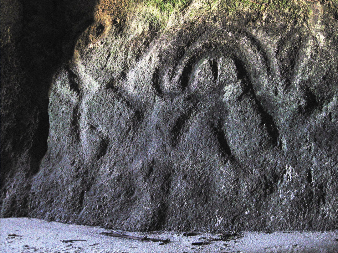
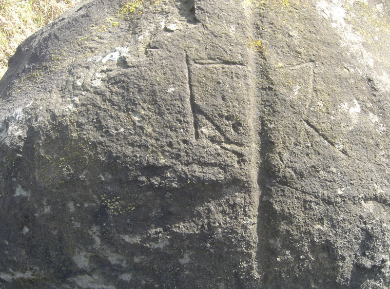
Just north of the Tonga Bay Stream is a 20-feet deep (6ft high & 4ft wide) seaside cave and, on the back wall is this glyph, the upper, central section of which clearly depicts Split Apple Rock. To the glyph's right side is a deeply incised line that brushes past the boulder. There is also a central incised line that orientates towards the central "V" of the boulder and a third line, again orientating onto the "V" mid-section. These deep incisions in solid, hard granite are quite obviously telling the reader of the glyph that the giant split boulder functions on 3 alignments, namely, summer-solstice, equinox and winter-solstice.
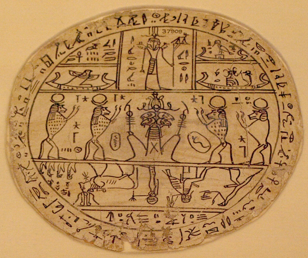
Hovering over the Split-Apple depiction is a very ancient solar glyph found from ancient Ireland to Egypt, depicting the corona or halo of the sun at its solstice and equinox positions.. Here are some examples:
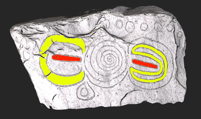
This is kerbstone K5 at Knowth Chambered Cairn, Boyne Valley, County Meath, Ireland, which dates to about 3125 BC (over 5000-years ago). The stone in its central spiral depicts the sun, moving from its most northern to southern reaches of the horizon, past the meridian (equinox) on its endless journey. The two omega-type glyphs to either side depict how to read the sun's rise and set positions to east and west, with the red sections representing the meridian fix and the end turn-around points representing the solstices.
Seven solar orbs are seen at the top of the kerbstone, in homage to the Sabbatical Calendar method of seven solar days in a week , as well as monitoring the solar count based upon cycles of 7-solar years.
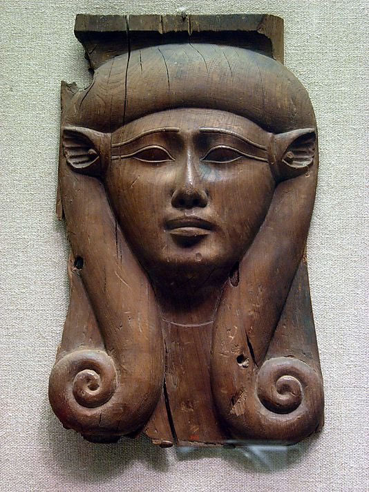
The Omega glyph is depicted in statues or busts of Hathor of Egypt, who was a solar diety. The two returning spirals deprict the sun at its winter solstice and summer solstice positions, with the vertical line of the nose, past the forehead, representing the equinox.
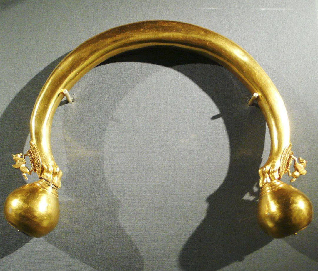
The many Celtic or Roman torque, neck jewellery artefacts are in homage to the endless journey of the sun, hence the gold colour and the Pegasus winged horse flying from the solstice positions to the equinox throughout the year. The bulbous ends of the torque, other than representing the summer and winter solstices, also depict the morning sunrise to the east and afternoon sunset to the west.
Amongst the Greeks, Pegasus Horses featured prominently in the solar myths,
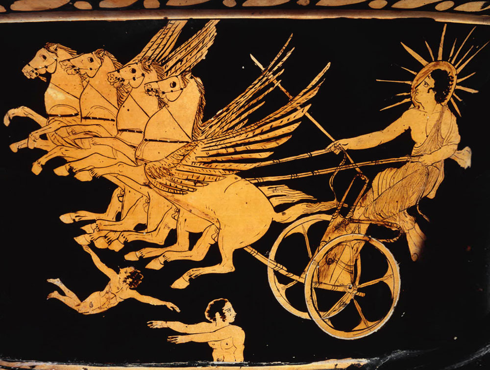
Hellios, the sun god of Greek mythology rides his chariot across the sky each day pulled by Pegasus winged horses.
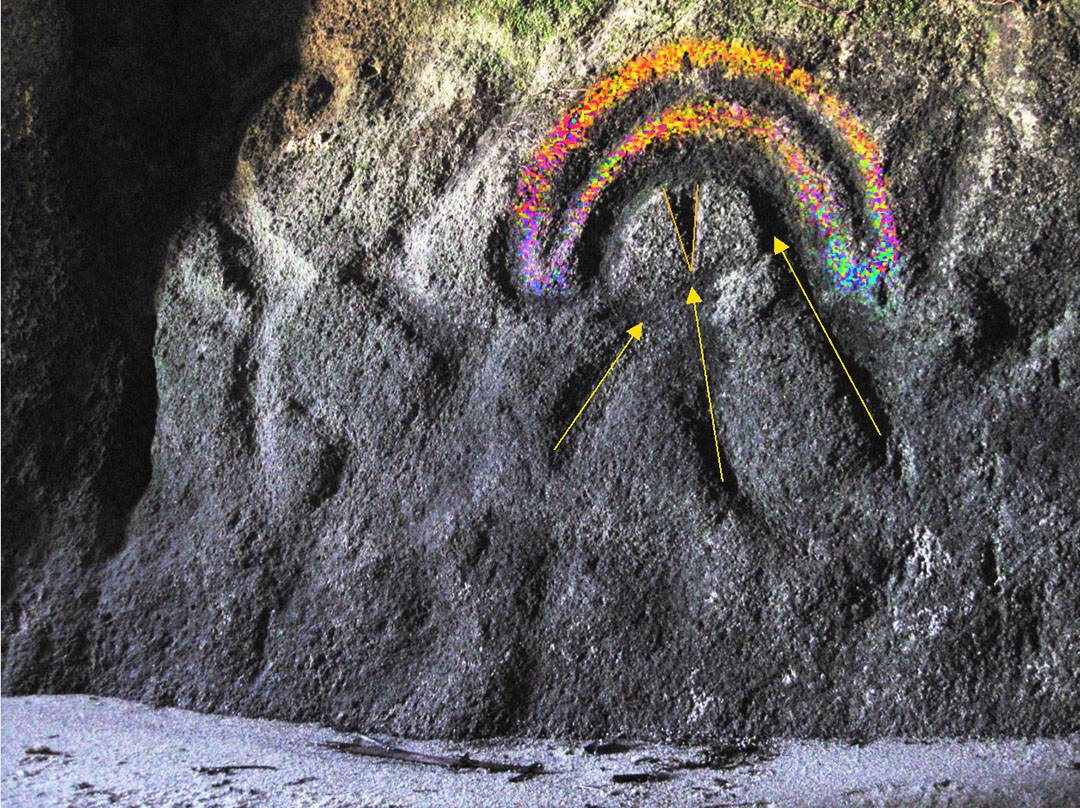
The ancient corona or halo glyph associated with many sun god depictions, spanning several civilisations, is most certainly seen to be hovering over the clearly incised Split Apple Rock glyph. Incised lines point to the "V" of the glyph or to the Split-Apple side. Given the immense effort and accomplishment to move the two halves of the boulder 10-miles down the coast and set it up on a platform of equally high quality granite boulders, it's little wonder the ancient astronomer-sun-worshippers would want to immortalise their accomplishment with this petroglyph at or near the site where the immense boulder originated.
The region around Split-Apple Rock, extending both up and down the coastline, was once host to a huge population, who carved flat plateaux and terraces into virtually every hill, peninsula or offshore island of the coastal region.
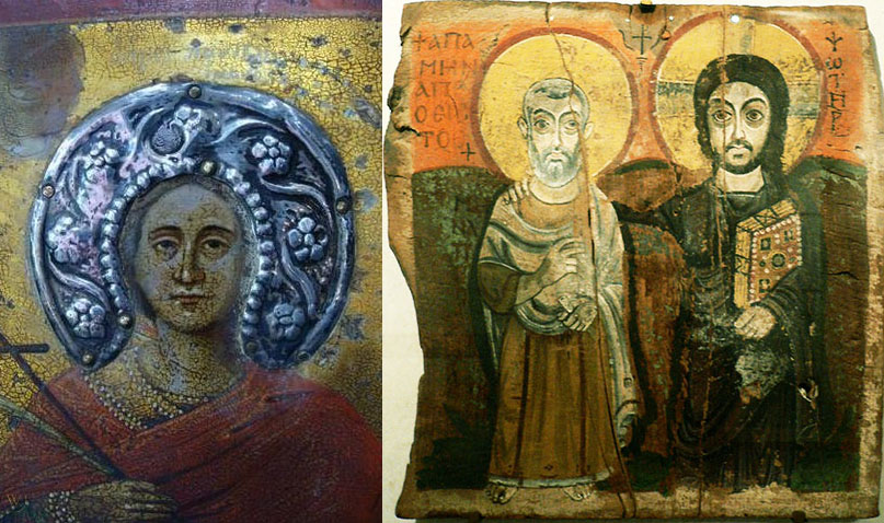
The halo of early Coptic Christian art was derived from much earlier cultural myths, religions, and gods. Petroglyphs or murals throughout the Mediterranean depict the passage of the sun god through the sky, as well as solar periods at and between the solstices and equinoxes. In the Greco-Palestinian picture to the left, the small orbs or knops around the head would represent solar day, week or month counts. To the right is seen a 6th century AD, Coptic (Egyptian) Christian portrayal of Christ with the abbot Mena. Both are shown with halo (sun) orbs around their heads, with the one adorning the Christ figure also including the encircled solar-cross of Taranis, god of thunder and lightening, the precursor design or central element in the Celtic Cross.
TE IKA O MAUI
The North Island of New Zealand is called, in the Maori language, Te Ika o Maui (the fish of Maui) and is represented as having been caught on a magical hook made from the jawbone of his grandmother, then hauled up from the deep by this ancient god of unknown origin. Quite surprisingly to some, the ancient Greek word for fish is ICHTHYS, which is very phonetically similar to the the Maori rendition of IKA.
For several centuries before the Christian epoch, Greco-religious iconography used the "Alpha"&"Omega" (first and last letters of the Greek alphabet) to represent fish symbols. Thus we have:

The Greek letters, Alpha & Omega, turned 90-degrees, were anciently used as fish and fertility symbols (ICHTHYS) in ancient Greek iconography. Centuries later, emerging Christianity adopted the fish symbol to represent their messiah, Jesus, who was referred to scripturally as "Alpha & Omega, the first and the last, the beginning and the end" (Revelations 22:13).
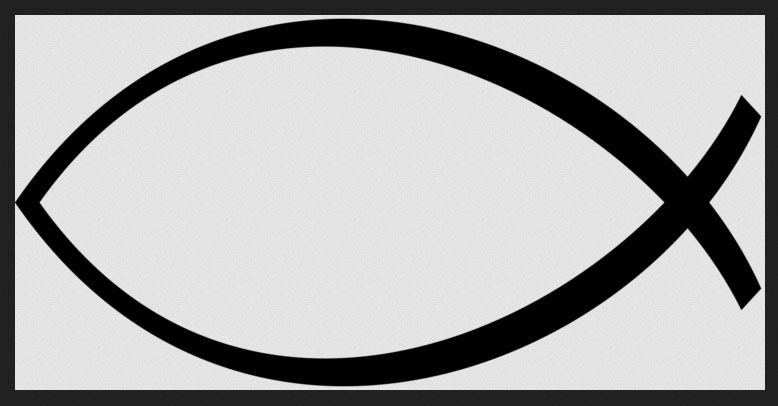
By the 2nd century AD, Christians had adopted ICHTHYS as the symbol for their deity. With Maori oral tradition mythologies, such as the legend of Mataoro & Niwareka, being an almost parallel story to the Greek myth of Orpheus & Eurydike, or Maori death / afterlife myths being so similar to Greek and Celtic myths on many levels, it's unsurprising that both cultures, half a world removed, share a near identical word for "FISH". See: http://www.celticnz.co.nz/CelticMaoriDeathMyths/CelticMaoriDeathMyths.html
The newly arriving Polynesian-Maori (circa 1300 AD) lived for about 10-generations alongside the earlier people and gleaned much from the long term inhabitants who had occupied New Zealand for many thousands of years. Thus numerous aspects of Maori culture or language show a pedigree back to ancient civilisations ranging from Egypt to India in one direction or to Continental Europe, the British Isles and Americas in the other direction.
One of these cultural expressions that found its way to the very ends of the Earth in New Zealand is the Egyptian / Berber chin tattoo on women, which duplicates the traditional chin "moko" worn by Maori women and often of the same or very similar design features

The tattoo on the chin of this Berber girl, an ancient people indigenous to the North West African Mediterranean or Atlantic coastlines, is reminiscent of the "Amon RA" stick figure (or squatting god), found from Egypt to New Zealand. This same design features in the modern-day alphabet of the Berber people and is displayed on their national flag. It is equivalent to the letter "Z".
'This Neo-Tifinagh script is based on the historical Lybico-Berber writing system, used from as early as antiquity by speakers of the Libyc languages throughout North Africa and on the Canary Islands. Most surviving texts and sources of that language are archaic funerary inscriptions on stone stelae and hard-to-date rock inscriptions. which, since there are no bilingual Arabic texts found, indicates a general disuse of the alphabet before the arrival of the Arabs. However, the alphabet survived as Tuareg Tifinagh among the Tuareg people well into modern times, used primarily for games and puzzles, short graffiti, rock art and brief messages'. https://menasymbolism.com/2018/12/22/the-letter-yaz/
A second glyph found in the Tonga Bay Cave, Tasman, New Zealand, depicts the same, squatting, arms raised, stick figure design, as found on the Egyptian Hypocephalis funerary amulet. The painted lips of the Berber girl seem to represent the wide head of the figure.
Regarding the Tonga Bay cave stick figure, the Archsite archaeological report states:
' Nearest the entrance is a human depiction such as an anthropomorph (tiki-figure), pecked with broad grooves (shallow and u-shaped about 5 cm wide), with a head dress raked down reach side and with flexed stick-like arms raised to either side. There appear to be stick legs. Height is about 65 cm and width with the flexed sticks about 110 cm. The position of the flexed stick ‘arms’ is very similar to that of figures in some south Canterbury rock carvings'
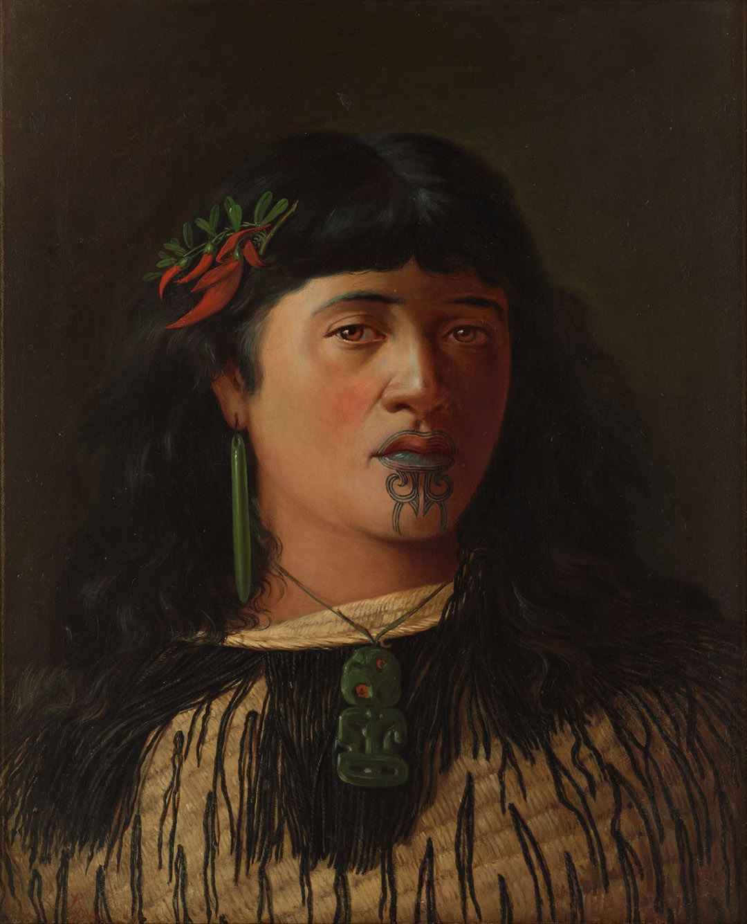
A somewhat more curvilinear depiction of the same stick figure design, and using the tattooed lines around the lip to form a head for the squatting figure, is found on this old painting of a Maori woman, half a world away from Berber, North West Africa. This particular tattoo (moko) design was widely adopted and adorned the chin & lips sections of many Maori women of the 19th century. For illustrations see: Maori Tattooing, by Horatio Gorden Robley, 1896.
The women of ancient Egypt wore a similar neck pendant to the greenstone "tiki" that adorns the Maori lady. The Egyptian pendants, generally carved from greenish-blue turquoise or jade-nephrite, were dedicated to Bes, the protector-god of mothers and children and the tiki shown above was predominantly for women only and seems to have had the same protector-god meaning.
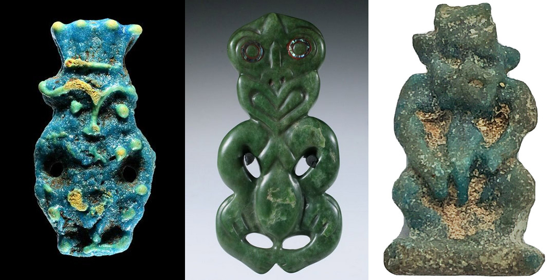
One of the oldest Maori tikis (centre) with the upright head is bracketed on each side by Egyptian pendants representing the protector-dwarf -god Bes. The one to the far left dates to about 330 BC and the one to the right could be considerably older. Egyptian women wore Bes pendants or had small Bes statuettes in their homes, especially where children were present. In mythology, Bes entertained, played music, danced for the children, killed snakes or scorpions and stood between the children when strangers approached, vetting them for any hint of ill-intent. If a threat was perceived Bes would attack fiercly to protect the children. In New Zealand Maori mythology there was a fearsome little dwarf-god and the Maori haka dance seems to have originally been a dance of Bes, indicating protection by the warriors of the women and children.
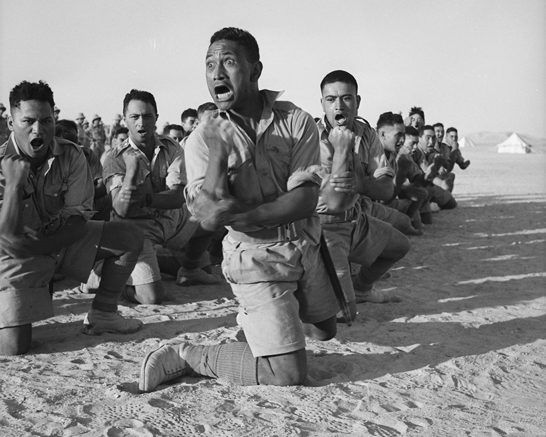
A central element of the Maori haka dance is that the performers remain in a stooped or squatting, dwarf-like position throughout, rolling bulging eyes, flashing the tongue, grimacing in a fearsome or angry fashion, stomping the feet menacingly and evoking threats of death. This is a challenge to an enemy or stranger, in much the same way that the dwarf-god Bes of Egypt is represented, with the same fearful attributes, to vet all comers in his role of protector-god to pregnant women, mothers and children.
In the Maori language of the 19th century, there were a series of compound words or references that inferred/ named the dwarf-god, amongst other names, as Ehi or Wehi. This is very significant because, in the Maori tongue there is no equivalent to the letters “B” & “S” and the name Bes or Bessie would be rendered as “Ehi or Wehi”, as all Maori words must end with a vowel. See: The Ancient History of the Maori, His Mythology and Traditions, by John White, Vol. 6.
 .
.
The centre figure of the Egyptian Hypocephalus funerary amulet is the squatting god, Amon RA, the supreme deity of Egyptian religion and the sun-god . He has staffs balancing on each knee, 4 rams heads looking to the 4 quarters of the Earth and a plumed crown. In essence, many or most of the features are encapsulated in the Berber and Maori chin tattoo designs, albeit in a more simplistic rendition. The supreme god of Maoridom was the sky and sun-god RA (Rangi).
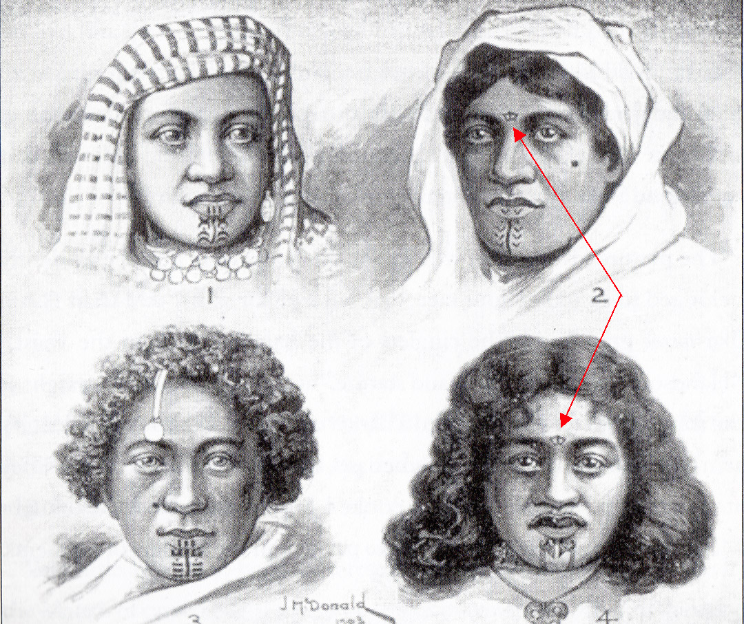
This picture shows 3 Egyptian women (listed 1,2,3) with a Maori woman listed as (4). The Egyptian women are Assouan, from Upper Egypt. All display chin, lip or forehead tattoos. This picture and an accompanying article appeared in The Journal Of The Polynesian Society, Volume XIII - 1905.
The article and picture first appeared in the Otago Witness newspaper, New Zealand and included the following commentary:
'The London correspondent of The New Zealand Times says, - 'General Robley, the well known authority upon Maori art, sends me a sketch that he made of Assouan villagers now on view themselves at Earl's Court'.
'The sketch shows that the married women of this tribe far up the Nile are tattooed in a manner remarkably similar to that in which the Maori women used to be tattooed, namely on the lips and chin and now and again on the forehead.... General Robley has found on some of the earlier Egyptian mummies certain ornamental designs, which have hitherto been considered purely Egyptian, but he finds that they are identical to some of the most ancient Maori patterns'
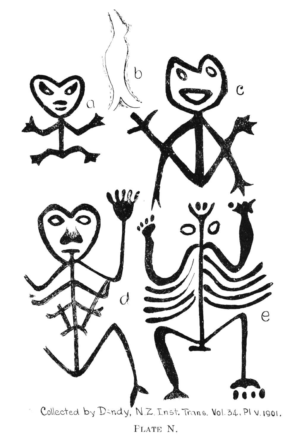
The squatting god is abundantly depicted in Moriori art of the Chatham Islands, a part of New Zealand. Inasmuch as the lips of Egyptian, Berber and Maori women were also tattooed, the lips also constituted a part of the full design and appear to be representative of the head of the squatting god in many traditional designs. The downwards pointing "V" configuration of the centre top lip beneath the nose would then duplicate the "V" chevron of the Moriori head design, as well as the prominent "V" on the forehead of the Egyptian , squatting dwarf god Bes, protector of mothers & children. The "V" is prominent on the forehead of all or most Maori totem carvings of figurines (tiki & protector god effigies that guard gateways and doorways).
A similar figurine is found in the cultural symbolism of the Chehalis Indians of the Fraser River country, Pacific Northwest, Washington, USA and extending into Canada.
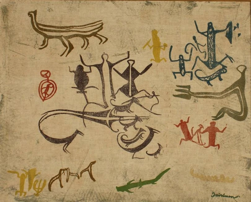
The squatting god figurines are found in profusion in very ancient cave or rock shelter art of New Zealand's South Island. The overall style seems to be a significant departure from the more recent eras of cultural symbolism and is probably very ancient. Similar stick figure designs are found in caves or on cliff-faces of the American southwest. The above picture is an artist's duplication of South Island, New Zealand rock art.
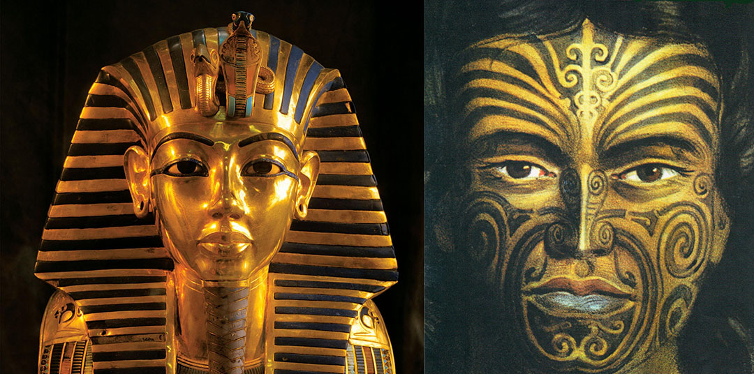
Some comparisons between the design features of Tutankhamun’s death mask and an early era Maori moko. Both societies were sun worshippers and the names for their supreme gods were RA & Rangi, respectively:
The same oddity holds true on the forehead area of the Maori chief’s moko.
If we count the dark eyebrows as stripes, then there are 6 dark stripes to the left and 7 to the right (13 in total). Alternatively, if we count the lighter skin, non-tattooed parts between, there are 6 stripes to the left and 7 to the right.
However, the centre vertical untattooed stripe is also counted, bringing the total of light stripes to 14.
It is significant that 13 X 14 = 182, which is the number of full days between equinoxes or ½ the number of full days in the 365.25-day year.
This usage of the Lotus flower symbol extended from ancient Egypt and its adjacent country, Canaan (Israel), where it was prominently displayed in the Hebrew Temple of Solomon. The Fleur de Lys symbol was used by the Berber people in some of their ancient or traditional tattoos and was adopted by French royalty.
On the centre band, below the Fleur de Lys is a cross bar and below that is a figure 8. This overall symbol represents the very ancient Caduceus, which has become our modern day medical symbol. The figure 8 is the inter-twined snakes of the Caduceus and in biblical mythology Moses is said to have raised a staff of this near design, called the Bronze Serpent, to cure his people from deadly snakebites. See: Numbers 21: 6-9.
The mask of Tutankhamun shows the same two snake-like elements in the centre of the forehead, namely the long neck and head of the vulture and the squirming body of the cobra.
Number combinations, represented by sections of stripes on Tutankhamun’s mask, multiplied by other sections, revealed scientific numbers related to durations in time (day, month, year counts) for cyclic astronomy, etc., the explanation for which would be too large for this article.
The moko-tattoo portrait of the young Maori chief was painted by George Angas in 1844, a time when Maori cultural symbolism was executed in a pure, traditional fashion, as handed down from the ancestors.
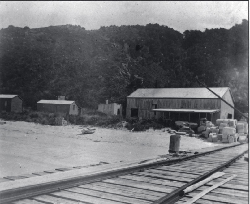
The Tonga Bay Quarry Company (1904 to 1921) work and dwelling buildings. The company flourished for a decade until about 1914, then wound down its operations and was finally struck off the register of companies in 1921.
At Tonga Island or the adjacent mainland large bulbous boulders, similar in size to split-apple rock, can still be seen at the water’s edge below the steep cliffs. Geological analysis of the constituent-composition of the Split-Apple boulder would pin-point the source from which the massive boulder was acquired.
The fact that the “V” in the split boulder orientates perfectly onto the winter solstice sunrise-point at the greatest extremity of the sun’s northern journey, coupled with the platform-cradle into which the boulder has been carefully placed and chocked, allowing the base of the “V” to conjunct simultaneously with the more distant cliff-edge and the sea horizon, demonstrates that this is a purpose-built structure and not a natural occurrence.
The opportunity is certainly there for geologists to study this anomaly and arrive at a definitive conclusion as to exactly where the boulder came from, but under the present, politically-correct impositions that dominate and restrict all New Zealand archaeology this won't happen.
As for the "summer" solstice sunrise position, as witnessed from the beach observation point from which the winter solstice & equinox events are viewed through the Split-Apple “V”, that would occur across the water on the high range that divides Nelson and Marlborough Provinces.
From the Split-Apple Rock beach observation position the summer solstice line would extend across the range to resolve at Wairau Bar, where there was a large Moa Hunter settlement conceivably centuries or even thousands of years before Maori arrived on New Zealand shores.
Like the Celts of ancient Europe, the pre-Maori people of New Zealand set up solar paths for the wayfarer, based upon the equinox and solstice rise & set positions in order to travel accurately between coastal settlements on both sides of the North & South Islands.
The ancient inhabitants of Wairau Bar lived contemporaneously with many species of the now long extinct Moa birds and were even buried with Moa eggs and Moa bone necklaces amongst their grave goods. These burials were obviously long before the Polynesian Maori arrived on these shores.
Although originally touted before the public as being "the first" Eastern-Polynesian settlement in New Zealand (circa 1300 AD), the experts vacillate on this centrally moot point. The fact that Moa eggs, bones and necklaces were found amongst the grave goods poses a big problem and every creative ploy possible has to be conjured up to drag the dates of habitation into the "Maori epoch". Such things as suggesting the original settlement was composed of a tiny group comprised of about 7-people, including women, washed up during the mid-1200s due to a "drift-mishap" seeded and colonised the entirety of New Zealand within 100-years. The ridiculous, unworkable population model proffered by our mainstream experts tells us:
With the Wairau Bar and elsewhere, scientifically-dated samples locked away from public view, our experts are now resorting to gobbledygook and double-speak to cover their proverbial arses before the public:
'...the dates used by Wilmshurst were from egg shell dates from Wairau Bar (Higham et al. 1999) that had a similar probability span as the more recently obtained dates, and that the 1280 CE date suggested was based on the tail of the probability curve which is not an indicator of the temporal span of the site.'
As Forest Gump might have said, 'Gwarsh, they must be real e-ja-kated folks ta tauk like thaa'.
Archaeological evidence of human made artefacts and cooked Moa bones, found beneath the volcanic ash-band layer at Poukawa, Hawkes Bay and dating from the circa 1350 BC Waimahia explosion (about 3400-years ago), attests to very early, Moa Hunter inhabitants of New Zealand.
When 13-year old Jim Eyles made the discovery of a skull and grave goods at Wairau Bar in 1939, it led to the site being considered the most significant find in New Zealand archaeological investigations up until that time or since. In reference to skeletons exhumed, Rangitane Maori elder, Manny MacDonald said:
“It’s nothing to do with us … He’s not one of us”.
This kind of freely proffered admission used to be common and prevalent amongst the learned Maori elders: Historian Edward Tregear observed:
“The Maoris used to pay great respect to the bones of their dead, yet here and there may be found among sandhills, etc., human remains uncovered by the wind, and of these no tradition remains, as there would certainly be if the relics were those of ancestors. The natives say, “These are the bones of strangers.” So also mortuary-caves are found concerning the contents of which the Maoris make the same remark, and regard them with indifference (See, The Maori Race, by Edward Tregear, pp. 562-563).
In an article written for The Tasmanian Journal of Science in 1842 CMS Mission Printer, William Colenso wrote about the lack of knowledge Maori had concerning the giant Moa birds:
“From Native tradition we gain nothing to aid us in our inquiries after the probable age in which this animal lived; for although the New Zealander abounds in traditionary lore, both natural and supernatural, he appears to be totally ignorant of anything concerning the Moa save the fabulous stories already referred to. If such an animal ever existed within the time of the present race of New Zealanders, surely to a people possessing no quadrupeds, and but very scantily supplied with both animal and vegetable food, the chase and capture of such a creature would not only be a grand achievement, but one also, from its importance, not likely ever to be forgotten, seeing, too, that many things of minor importance are by them handed down from father to son in continued succession from the very night of history. Even fishes, birds, and plants anciently sought after with avidity as articles of food, although having never been seen by either the passing or rising generation of aborigines, are, notwithstanding, both in habit and uses, well known to them from the descriptive accounts repeatedly recited in their hearing by the old men of the village.”
Taking, then, the paucity of tradition as he supposed it, together with such other facts as he found them, Mr. Colenso came to the conclusion that:
“The period of time, then, in which I venture to conceive it most probable the Moa ceased to exist was certainly either antecedent or coetaneous to the peopling of these islands by the present race of New Zealanders.”
Likewise, Julius Von Haast drew the same conclusion after considerable research and interviews conducted with Maori in the South Island.
The solar observatory related attributes of Split-Apple Rock, as well as the huge engineering feat to set it up, has nothing recognisable to the known endeavors of the late arriving Polynesian-Melanesians and undoubtedly stems from an altogether different age and people who occupied New Zealand at a far more remote epoch.
THE KAITERITERI TOWNSHIP WINTER SOLSTICE SUNRISE OBSERVATORY.
Again, at Kaiteriteri township is yet another cairn heap of natural boulders that could have been purpose-modified to act as a component part of yet another winter solstice sunrise observatory. The cairn heap sits 1.18-miles down the coast from Split-Apple Rock and serves the same exacting function as the cliff edge onto which Split-Apple rock orientates for fixing onto the winter solstice.
Although a perfectly natural geological formation, conveniently the heap centre, composed of a giant upright boulder sits, once again, about 330-feet (100 metres) from a “V” formed by an onshore bluff-peninsula and an offshore island.
A winter solstice observation line runs from the beach area of Kaiteriteri Township, passes through the "V" gap between the island and headland and resolves to the shoreline side of the cairn heap’s high centre.
An aerial shot of the winter solstice sun making its "first-glint"appearance over the sea horizon at Kaiteriteri. For a video see: https://youtu.be/WQpE1_dC5kUt
By observing from the beach (station 1), viewing through the “V” (station 2), using the side of the boulder cairn for accurate orientation (station 3) and watching the winter solstice sunrise (station 4) the Kaiteriteri township modus operandi duplicates that of the Split-Apple Rock solar observatory further up the coast.

The winter solstice sun continues its rise.
The Kaiteriteri beach park-bench sits empty as photographer Serenity witnesses the winter solstice through natural geological features, once utilised by New Zealand’s ancient inhabitants, to capture this significant annual event.
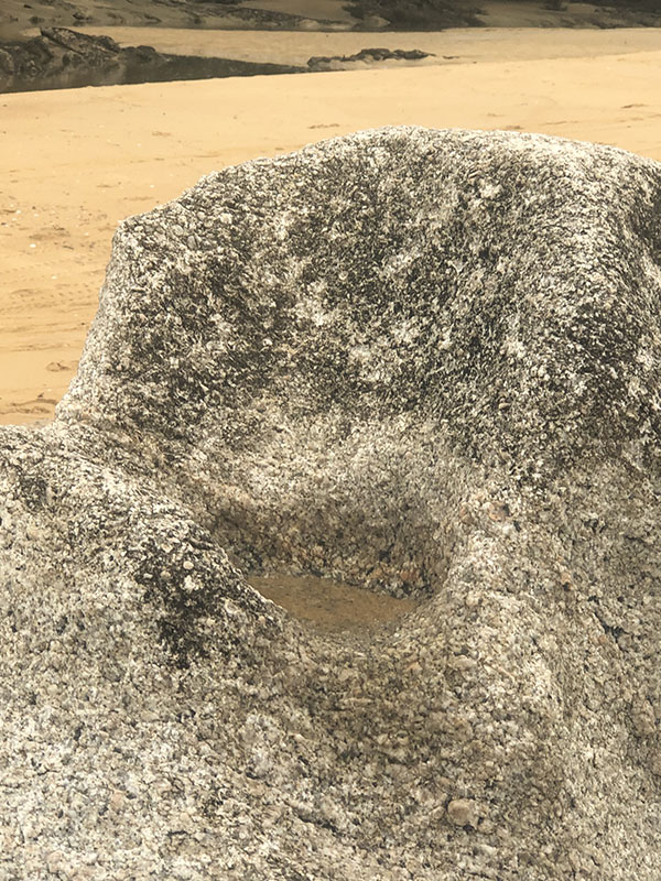
Very near to the position one needs to be at to witness this annual phenomenon are two bullaun bowls carved into very durable, crystalline boulders sitting at the high tide mark. In ancient Europe such bullauns would have been used for ritual prayers on a "blessing & cursing altar".
Modern day Kaiteriteri residents are oblivious to the fact that they have this archaeological-astronomical treasure sitting on their sea-front doorstep and there wasn't’t another soul in sight. Serenity had the entire breath-taking moment all to herself. She was witnessing something that had been lost from memory … an ancient, working solar observatory that has escaped recognition for centuries or millennia.
The warming rays of the sun bath the frigid waters of the bay, creating a path of steamy mist.
Whereas the Split-Apple observatory provided a very finite fix on the winter solstice, suitable for an astronomer-priest to determine the actual solstice day for the benefit of the regional community, the Kaiteriteri observatory would provide a magnificent spectacle to the general population, where large numbers could gather together to witness and celebrate the solar event.
BULLAUN BOWLS FOR BLESSING & CURSING ALTARS AND CEREMONIAL CLEANSING
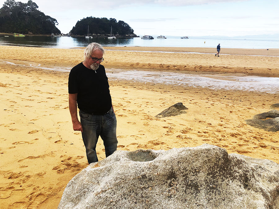
The author observes an ancient bullaun bowl, filled with seawater and cut deeply into into very hard crystalline rock. This bowl and a second one nearby are situated at the position where the sun is seen to rise in the gap in the background at the time of the winter solstice. This region of the beach would have been an assembly area for the rank & file of ancient Patu-paiarehe/ Turehu society to celebrate the significant solar event of mid-winter.
The tide washes into the bowls twice a day and, in keeping with known practices elsewhere, this was a place for ritual cleansing, as well as blessing prayers or cursing incantations. The use of bullaun bowls for religious purposes represented profound religious expressions of ancient European/Mediterranean civilisations and those practices persist to this day in areas of Ireland.
The second bullaun at the assembly area. Adjacent to this is a boulder with directional incising on it.
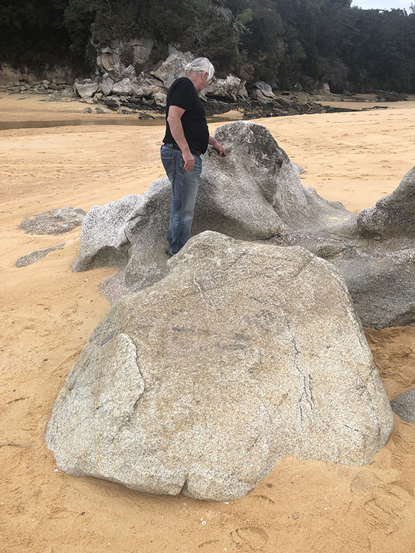
The author inspects the 2nd bullaun. In the foreground the hard boulder is seen to have a straight-line, geometric pattern incised into its top surface. One line seems to orientate onto the headland and island gap where the winter solstice sunrise occurs. Other lines seem to relate to the equinox and summer solstice sunrise points or sunset points on the distant range across the harbour on the eastern range or another nearby range to the west.
A close up of some of the incised geometry, which undoubtedly relates to the solar rises on the distant eastern range and at least some solar set positions on the nearer western range.
Here's an example of the same kind of directional incising as found on an ancient boulder, formerly at Silverdale, Auckland, North Island (the boulder now destroyed to make way for a subdivision). Note the wide, long incising mark traversing through the centre of the other geometry. This boulder sat in full view of Chin Hill with its huge, ancient "V" cut into its southern side.
Observing the solstices and equinoxes assured everyone that their calendar counts throughout the year remained true, such that planting and harvesting of crops was done on time or determining when fish and bird migrations could be expected to commence, etc. Regulating life by accurate calendars gave ancient populations the best possible chance of survival and enjoying abundance.
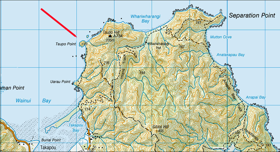
TAUPO POINT PA (FORTRESS) SOLAR OBSERVATORY, GOLDEN BAY
Traveling northwest around the coastline from Kaiteriteri and Split Apple Rock one bypasses Separation Point lighthouse, to the west of which is a place of ancient habitation called Taupo Point PA. On December 19th, 1642 warriors, seemingly from this PA, canoe-rammed a row boat containing Dutch sailors of Abel Tasman’s exploratory expedition, resulting in 4 men being beaten to death by Maori or drowned. Abel Tasman then named the area “Murderer’s Bay” and sailed away.
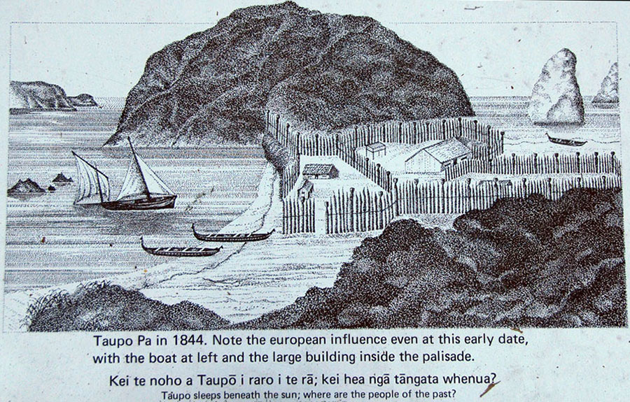
The sign that sits at the former position of Taupo Point Pa, showing an artist’s impression of how the site looked in 1844. A traditional Maori saying or proverb associated with this site is:
‘Taupo sleeps beneath the sun; where are the people of the past?’
Note: Whenever the term Tangata Whenua was uttered or written throughout the 19th century and most of the 20th century, it always meant the strangers … Patu-paiarehe, Turehu, etc.) who inhabited New Zealand before the circa 1300 AD epoch of the Polynesian-Melanesian Maori.
A DOC (Department of Conservation) article, devoted to this region at the northern end of the South Island, touches upon legends of pre-Maori inhabitants:
'Maori cosmology and creation myths tell of predecessors of the earliest inhabitants of the region. Traces of their passing remain in the features of the landscape and names they have been given'.
Let's look at some of the handiwork left by the earlier people and the function of some landscape features as solar observatories ... for getting accurate sun-fixes on significant calendar dates:
THE WINTER SOLSTICE SUNSET, OBSERVED FROM THE SIGHTING PITS OF TAUPO POINT PA
Around New Zealand, many so-called Pa or settlements created by the Patu-paiarehe people doubled as solar observatories and Taupo Point Pa was no exception to this. Oft-times, these sites could not realistically serve the function of a defense area, so must have been built for another purpose.
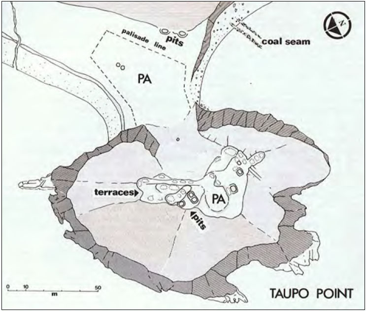
Although the hillock peninsula is now thickly clad in trees, the former, purpose-built excavations were identified in an archaeological survey of the site by archaeologist Barry Brailsford. Amongst these dug features were sighting pits, where observers could sit in a set or fixed position of orientation. Site-plan courtesy of Barry Brailsford, from The Tattooed Land, pp. 83-83, Reed Publishing, 1981.
The archaeological report of 1972 assessed the hillock site as being unsuitable for defense and states: ‘A very suitable site for a kainga (food gathering location), but hardly defendable as a pa, especially for its small size’.
The report went on to note: ‘Limestone outcrops make occupation unlikely.’
So, as long as no enemy was threatening, the area would have been a wonderful place to live long-term, with abundant sea resources and a micro-climate that produces, on average, more annual sunshine and clear days than other regions of New Zealand.
THE COLLINGWOOD HILL RANGE TO THE NORTHWEST
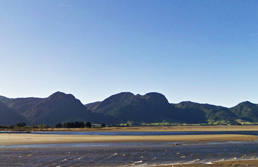
A little over 19-miles to the northwest of Taupo Point, on the range above Collingwood township, is this outstanding geological feature, which would represent a perfect outer-marker target for a winter solstice sunset. The hill is a part of the Northwest Nelson Conservation Park.
While exploring the region at the time of the winter solstice, Serenity was intrigued to see the sun almost alighting on this hill and took several photos as a consequence.
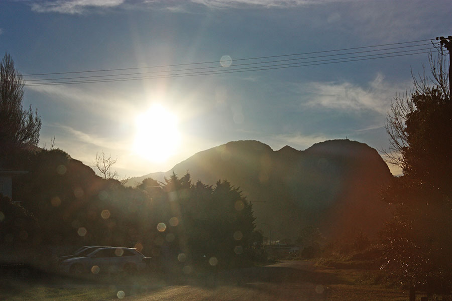
The setting winter solstice sun overshoots the gun sight shaped hill on Collingwood range, which means that if the ancient astronomers wished to use the centre-hill as an outer-marker for the winter solstice fix, their observation point or station would have to be on an alignment that sat slightly further to the north.
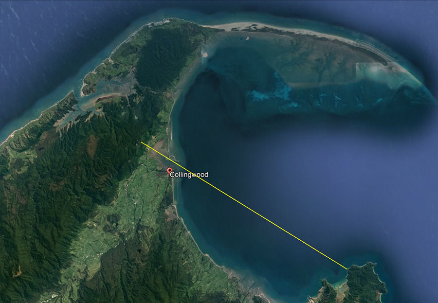
By back-calculating the required angle we found the position. A line-of-sight runs from the sighting pits atop Taupo Point Pa hillock to the centre of Collingwood's outstanding hill up on the range.
Calculations undertaken in Red Shift Astronomy Program verified that the sun would land in the centre of the Collingwood Hill, 19.5-miles distant, @ 301.66-degrees on the evening of the winter solstice, as witnessed from the observer’s position atop Taupo Point Pa.
Yes indeed, ‘Taupo sleeps beneath the sun; where are the people of the past?’
They are long gone now, vanquished from the region and not allowed to be remembered, but their working, sophisticated solar observatories yet remain as an eternal witness to Patu-paiarehe society’s presence and deep-set cultural practices.
Our old 19th century New Zealand history books quote many of the oral histories recounted by the tohunga and learned elders of the Maori of old and are replete with references to the long-term inhabitants incoming Maori found when they arrived.
These solar observatories at Kaiteriteri, Split-Apple Rock and Taupo Point are the handiwork of the ancient, former inhabitants and could be several thousand years old.
Let’s now move to yet another "Taupo" in the central North Island of New Zealand and look at some of other solar observatories tested during the Southern Hemisphere winter solstice of 2018.
TAUPO
On the shores of Lake Taupo, at Wharewaka, a new subdivision was created in 2004 and, during entry-road widening onto the site a giant boulder had to be moved out of the way. Local educator-historian, Graham Parminter alerted me to the fact that the giant boulder had, what is very obvious to all who see and inspect it carefully, a human-carved seat in it.
Prior to 2004 the carved seat had faced the centre cone of Mount Tauhara, a dormant, lofty volcano that dominates the skyline to the ENE.
This anomaly has led this researcher to do concentrated probes of the district, making further amazing discoveries related to the “devil’s chair”-type boulder (as it would be called in Ireland, etc.) and its position of placement as an overland alignment, surveying position.
The giant boulder lying recumbent on its side, with the carved seat (formerly the top of the boulder) seen at its bottom right in this picture.
For a comprehensive review as to the original purposes of this huge boulder see: http://www.celticnz.co.nz/TaupoStones/TaupoStonesPart14.html
The chair is also a component part of an overland mapping alignment that extends from Mt Edgecumbe near Kawerau on the East Coast, to Taupo and across the top of the “Devil’s Chair”, then over Motutaiko Island in the middle of Lake Taupo, then over the summit of (presently) dormant volcano Mount Tongariro. The survey line extends to the South Island, scooting past Kaiteriteri Township at a point 15-miles SSE, then resolves on Mt Cook, the highest mountain in New Zealand.
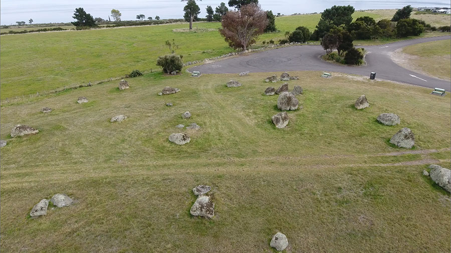
Sitting 611-feet away SE from the “devil’s chair” boulder is a secondary, standing-stone site of large obelisks and, from experience with other sites around the country or Continental Europe - Mediterranean - British Isles, etc., I would describe this one as an assembly area for the general population, where they could gather together to celebrate festival events or learn cyclic-astronomical and navigational knowledge under the tutelage of a highly trained instructor.
THE WINTER SOLSTICE SUNRISE FROM THE CENTRE CONE OF MT TAUHARA VOLCANO
Centrally positioned amidst the standing stones is a particularly large one, which, because of its size is recognizable as the hubstone or centre of the site.
See: http://www.celticnz.co.nz/SolarObservatoriesNZ/SolarObservatoriesPart3.html
From that position the winter solstice sun rises perfectly from the very centre of extinct volcano, Mount Tauhara.
Around New Zealand there are many such occurrences, where the ancient, pre-Maori inhabitants set up solar observatories and, where possible, the outer-marker for sunrise or sunset was a volcano. This was their way of returning fire to the volcanoes at equinoxes or solstices and, in the process, keeping their annual calendar counts 100% accurate. They were also a people who venerated the sun or sun-god and solar events were of great importance to them.
Our pre-calculations in the astronomy program, Red Shift, were right on the button and the sun rose perfectly from the centre crater of extinct volcano, Mount Tauhara when viewed from the central hubstone of the assembly area.
Just like at Kaiteriteri solar observatory the winter solstice sun finally obscured the outer-marker volcano in a blaze of blinding light.
On the top of the hubstone boulder, from which Mount Tauhara was targeted, there appears to be a now somewhat broken bullaun bowl carved into the surface. For auspicious occasions such as the winter solstice celebration this would have been filled with water. In ancient Ireland, as elsewhere in Megalithic Great Britain or Continental Europe the bullauns were used for ritual washing or prayers and were carved into the blessing and cursing altar boulders (circa 3000 BC and after).
To the right of the picture is seen little Maunganamu (Mosquito Mountain) and, from the standing stone circle’s hubstone the equinoctial sun rises at its southern base, then climbs up the side of the mountain to launch itself into the sky. From the hubstone and very carefully placed assembly area outlier boulders, Maunganamu was the equinoctial sunrise outer marker.
THE EQUINOX SUNRISE FROM THE BASE OF MAUNGANAMU MOUNTAIN
Whereas first glint of the sun rise on the winter solstice is precisely in the cone of Mt Tauhara, at the equinox it is at the southern base of Maunganamu Mountain. The sun then climbs the mountainside and launches itself into the sky.
The southern base of Maunganamu Mountain provided a perfect fix for determining the exact day of the autumnal or vernal equinox days.
The hubstone, from the top of which our sunrise & sunset videos were shot with a 4K camera. We also used a camcorder on a tripod at the base of this stone and still cameras.
THE WINTER SOLSTICE SUNSET
The winter solstice sun alights upon a hill atop the range situated above Acacia Bay and its blinding light obscures its very important landing position. To the left of the picture is seen the tower atop Tuhingamata Hill where there is yet another solar observatory, marked by obelisks, that uses Mount Tauhara as an equinox outer marker.
The winter solstice sun alights upon a hill atop the range, then slips down into a dip on the hill's southern side. There are, apparently, Maori legends and oral traditions about the great importance of the hill, but no-one seems to know why it is so important. Now that we know it was the outer marker for the winter solstice sunset, chosen by the ancient pre-Maori astronomers (Ngati-Hotu), its importance becomes clear.
THE EQUINOX SUNSET
The equinoctial sun sets on the distant range in line with the extreme end of Rangatira Point, the ancient location of Ponui PA. Rays from the sun extend towards the hubstone of the standing stone circle and cross over the top of another, outlier standing stone used for orientation onto the equinox sunset point on the horizon.
The ancient standing stone arrangement on the shores of Lake Taupo, abandoned and not used for the avowed purpose for which it was built since the original inhabitants were driven from the region by incoming Arawa and later Tuwharetoa Maori warriors. The newcomers seemingly never gleaned or gained knowledge of how the site worked or its significance.
The central large boulder seen towards the hillock summit is the hubstone and, in keeping with how other standing stone sites work overseas, the positions of outliers are at coded distances and angles away from it. The encoded measurements and angles themselves relate to such things as the lunar cycle durations, lunisolar calendar calculations, the equatorial circumference of the Earth (under two systems of ancient navigation) as well as solstice and equinox solar observations essential to keeping the calendar 100% accurate.
The key to unlocking the codes of this site is in the realisation that the British Standard inch and foot have a much older pedigree than of that assumed by our so-called experts and are in direct ratio to the cubits of the great civilisations of antiquity. Code-bearing numerical values are also generated by use of the ancient 360-degree angle system attributed to the Sumerians (but which is, in reality, much older than that civilisations).
For a comprehensive analysis related to the encoded attributes of what survives of this standing stone arrangement and its distant, purpose-placed, outlier boulders see::
http://www.celticnz.co.nz/SolarObservatoriesNZ/SolarObservatoriesPart1.html (13-parts)
Martin Doutre 29/6/18, with updated information on 24/3/2019. ©